Show Navigation
|
Hide Navigation
How Fill works |
|
|
Release 9.2
Last modified January 3, 2008 |


|
Sinks (and peaks) are often errors due to the resolution of the data or rounding of elevations to the nearest integer value.
Sinks should be filled to ensure proper delineation of basins and streams. If the sinks are not filled, a derived drainage network may be discontinuous.
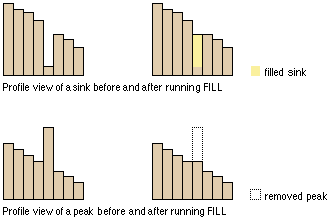
Fill uses the equivalents of several functions such as Focal Flow, Flow Direction, Sink, Watershed, and Zonal Fill to locate and fill sinks. The function iterates until all sinks within the specified Z limit are filled. As sinks are filled, others can be created at the boundaries of the filled areas, which are removed in the next iteration.
For nonSDTS USGS 30-meter resolution DEMs, Tarboton et al (1991), found that from 0.9 to 4.7 percent of the cells in a DEM were sinks. The mean adjustment of these sinks ranged from 2.6 to 4.8 meters. This means that for a 1,000 by 1,000 cell grid (1 million cells), there may be 9,000 to 47,000 sinks to be filled. Other DEM data sources may have higher or lower percentages of sinks, depending on how the surfaces were processed.
Example
To fill all sinks whose depth is less than 100 meters, the Fill settings would be:
Input surface raster = "elevation"Output surface raster = "fill_ras1"Z limit = "100"
Reference
Tarboton D. G., R. L. Bras, I. Rodriguez–Iturbe. 1991. On the Extraction of Channel Networks from Digital Elevation Data. Hydrological Processes. 5: 81-100.