Geoprocessing tool reference > Analysis toolbox > Overlay toolset > Tools
Update (Analysis) (ArcInfo only) |
|
|
Release 9.2
Last modified January 13, 2009 |


Print all topics in : "Tools" |
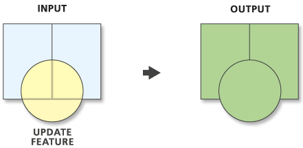
Computes a geometric intersection of the Input Features and Update Features. The attributes and geometry of the Input Features are updated by the Update Features. The results are written to the Output Feature Class.
Learn more about how Update works
Illustration
Usage tips
-
The Input Features must be of type polygon.
-
The Update Features must be polygon.
-
Output may be multipart. If multipart features are not desired, use the Multipart to Singlepart tool on the output.
-
The input geodatabase will not be modified by this tool. The results of the tool will be written to a new feature class.
-
The Input Features and Update Features field names must match.
-
If the Borders parameter is unchecked in the dialog box (or set to NO_BORDERS in scripting or at the command line), the polygon boundaries along the outer edge of the Update Features will be dropped. Even though the outer boundaries of some update polygons are dropped, the attributes of the Update Features that overlap Input Features will be assigned to the polygons in the Output Feature Class.
-
The following environment settings affect this tool: Coordinate system, Extent , XY Tolerance, Z Tolerance, M Tolerance, XY Resolution, Z Resolution, M Resolution, Output XY domain, Output Z domain, Output M domain, Output has M values, Output has Z values, Default Z value, Configuration keyword, Output Spatial Grid.
Command line syntax
An overview of the Command Line window
Update_analysis <in_features> <update_features> <out_feature_class> {BORDERS | NO_BORDERS} {cluster_tolerance}
| Parameter | Explanation | Data Type |
| <in_features> |
The input feature class or layer. Geometry type must be polygon. |
Feature Layer |
| <update_features> |
The features that will be used to update the Input features. Geometry type must be polygon. |
Feature Layer |
| <out_feature_class> |
The feature class to contain the results. Do not set this to be the same as the Input Features. |
Feature Class |
| {BORDERS | NO_BORDERS} |
Specifies whether the boundary of the update polygon features will be kept.
|
Boolean |
| {cluster_tolerance} |
The minimum distance separating all feature coordinates (nodes and vertices) as well as the distance a coordinate can move in X or Y (or both). You can set the value to be higher for data that has less coordinate accuracy and lower for datasets with extremely high accuracy. |
Linear unit |
Command line example
update_analysis city_lots.shp flood_levels/polygon c:\city.mdb\low_lots DROP_BORDER 0.0003
Scripting syntax
About getting started with writing geoprocessing scripts
Update_analysis (in_features, update_features, out_feature_class, keep_borders, cluster_tolerance)
| Parameter | Explanation | Data Type |
| in_features (Required) |
The input feature class or layer. Geometry type must be polygon. |
Feature Layer |
| update_features (Required) |
The features that will be used to update the Input features. Geometry type must be polygon. |
Feature Layer |
| out_feature_class (Required) |
The feature class to contain the results. Do not set this to be the same as the Input Features. |
Feature Class |
| keep_borders (Optional) |
Specifies whether the boundary of the update polygon features will be kept.
|
Boolean |
| cluster_tolerance (Optional) |
The minimum distance separating all feature coordinates (nodes and vertices) as well as the distance a coordinate can move in X or Y (or both). You can set the value to be higher for data that has less coordinate accuracy and lower for datasets with extremely high accuracy. |
Linear unit |
Data types for geoprocessing tool parameters
Script example
# Create the geoprocessor
import arcgisscripting
gp = arcgisscripting.create()

# Use error trapping in case a problem occurs when running the Update tool
try:
    gp.workspace = "c:/data/city.mdb"
    gp.Update("lots", "c:/test_data/shp/cutzones.shp", "c:/test_data/gdb.mdb/futurecut", "only_fid" "0.25")

except:
    print gp.GetMessage()