Geoprocessing tool reference > Cartography toolbox > Symbolization Refinement toolset > Tools
Create Underpass (Cartography) (ArcInfo only) |
|
|
Release 9.2
Last modified July 13, 2007 |


Print all topics in : "Tools" |
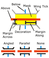
Generates mask polygons at the intersections of stroke representations to symbolize one set of strokes passing under the other. Optionally, linear parapet features can be generated adjacent to these masks.
Illustration
Usage tips
-
Requires intersecting line features symbolized with stroke representations as inputs.
-
Feature classes without representations are not supported by this tool.
-
The Input Above Representations layer can be the same as the Input Below Representations layer in the case of self-overlapping features.
-
When Input Above and Input Below representations are the same, a SQL expression is encouraged for further refinement of feature selection.
-
Overpass masks are created based on the user-indicated margin sizes.
-
The Where clause uses the fields from the Input Below Representations.
-
For further details on the syntax for the Expression parameter, see Building a SQL Expression or SQL Reference.
-
The following environment settings affect this tool: referenceScale, cartographicCoordinateSystem
Command line syntax
An overview of the Command Line window
CreateUnderpass_cartography <in_above_features> <in_below_features> <margin_along> <margin_across> <out_underpass_feature_class> <out_mask_relationship_class> {where_clause} {out_decoration_feature_class} {ANGLED | PARALLEL | NONE} {wing_tick_length}
| Parameter | Explanation | Data Type |
| <in_above_features> |
The input line feature layer containing stroke representations that intersect — and will be symbolized as passing above — stroke representations in the Input Below Features. |
Layer |
| <in_below_features> |
The input line feature layer containing stroke representations that intersect — and will be symbolized as passing below — stroke representations in the Input Above Features. These features will be masked by the polygons created in the Output Overpass feature class. |
Layer |
| <margin_along> |
Sets the length of the mask polygons along the Input Above Features by specifiying the distance in page units that the mask should extend beyond the width of the stroke symbol of the Input Below Features. The Margin Along must be specified, and it must be greater than or equal to zero. Choose a page unit for the margin; the default is points. |
Linear unit |
| <margin_across> |
Sets the width of the mask polygons across the Input Above Features by specifiying the distance in page units that the mask should extend beyond the width of the stroke symbol of the Input Below Features. The Margin Across must be specified, and it must be greater than or equal to zero. Choose a page unit for the margin; the default is points. |
Linear unit |
| <out_underpass_feature_class> |
The output feature class that will be created to store polygons to mask the Input Below Features. |
Feature Class |
| <out_mask_relationship_class> |
The output relationship class that will be created to store links between Underpass mask polygons and the stroke representations of the Input Below Features. |
Relationship Class |
| {where_clause} |
An SQL expression used to select a subset of features in the Input Below Features. The syntax for the expression differs slightly depending on the data source. For example, if you're querying file or ArcSDE geodatabases, enclose field names in double quotes: "MY_FIELD" If you're querying personal geodatabases, enclose fields in square brackets: [MY_FIELD]. For more information on SQL syntax and how it differs between data sources, see SQL Reference. |
SQL Expression |
| {out_decoration_feature_class} |
The output line feature class that will be created to store parapet features. |
Feature Class |
| {ANGLED | PARALLEL | NONE} |
Specifies the wing style of the parapet features.
|
String |
| {wing_tick_length} |
Sets the length of the parapet wings in page units. The length must be greater than or equal to zero; the default length is 1. Choose a page unit (Points, Milimeters, and so on) for the length; the default is Points. This parameter does not apply to the Wing Type - NONE. |
Linear unit |
Command line example
CreateUnderpass_cartography c:\workspace.mdb\roads.lyr railroads.lyr 2 3 masksFC masks.rel underpassFC ANGLED 1
Scripting syntax
About getting started with writing geoprocessing scripts
CreateUnderpass_cartography (in_above_features, in_below_features, margin_along, margin_across, out_underpass_feature_class, out_mask_relationship_class, where_clause, out_decoration_feature_class, wing_type, wing_tick_length)
| Parameter | Explanation | Data Type |
| in_above_features (Required) |
The input line feature layer containing stroke representations that intersect — and will be symbolized as passing above — stroke representations in the Input Below Features. |
Layer |
| in_below_features (Required) |
The input line feature layer containing stroke representations that intersect — and will be symbolized as passing below — stroke representations in the Input Above Features. These features will be masked by the polygons created in the Output Overpass feature class. |
Layer |
| margin_along (Required) |
Sets the length of the mask polygons along the Input Above Features by specifiying the distance in page units that the mask should extend beyond the width of the stroke symbol of the Input Below Features. The Margin Along must be specified, and it must be greater than or equal to zero. Choose a page unit for the margin; the default is points. |
Linear unit |
| margin_across (Required) |
Sets the width of the mask polygons across the Input Above Features by specifiying the distance in page units that the mask should extend beyond the width of the stroke symbol of the Input Below Features. The Margin Across must be specified, and it must be greater than or equal to zero. Choose a page unit for the margin; the default is points. |
Linear unit |
| out_underpass_feature_class (Required) |
The output feature class that will be created to store polygons to mask the Input Below Features. |
Feature Class |
| out_mask_relationship_class (Required) |
The output relationship class that will be created to store links between Underpass mask polygons and the stroke representations of the Input Below Features. |
Relationship Class |
| where_clause (Optional) |
An SQL expression used to select a subset of features in the Input Below Features. The syntax for the expression differs slightly depending on the data source. For example, if you're querying file or ArcSDE geodatabases, enclose field names in double quotes: "MY_FIELD" If you're querying personal geodatabases, enclose fields in square brackets: [MY_FIELD]. For more information on SQL syntax and how it differs between data sources, see SQL Reference. |
SQL Expression |
| out_decoration_feature_class (Optional) |
The output line feature class that will be created to store parapet features. |
Feature Class |
| wing_type (Optional) |
Specifies the wing style of the parapet features.
|
String |
| wing_tick_length (Optional) |
Sets the length of the parapet wings in page units. The length must be greater than or equal to zero; the default length is 1. Choose a page unit (Points, Milimeters, and so on) for the length; the default is Points. This parameter does not apply to the Wing Type - NONE. |
Linear unit |
Data types for geoprocessing tool parameters
Script example
import arcgisscripting
gp = arcgisscripting.create()

gp.workspace = "c:\Workspace.mdb"
gp.toolbox = "cartography"
gp.CreateUnderpass("roads.lyr", "railroads.lyr", 2, 3, "masksFC", "masks.rel", "underpassFC", "ANGLED", 1)