Mapping and visualization > An overview of mapping and visualization
Cartographic representations |
|
|
Release 9.2
Last modified November 7, 2007 |


Print all topics in : "An overview of mapping and visualization" |
Using map layers in ArcMap allows you to assign symbols and labels to the underlying feature geometry. Yet sometimes, you'll need additional control over how to portray cartographic representations in the map, and often the freedom to use a depiction that employs map representations that differ from your GIS feature geometries.
One of the mechanisms that can be used to portray features using map layers in ArcMap is to use cartographic representations. A cartographic representation is a set of rules, overrides, and graphical edits that allow you to represent features cartographically without having to modify the underlying feature geometry.
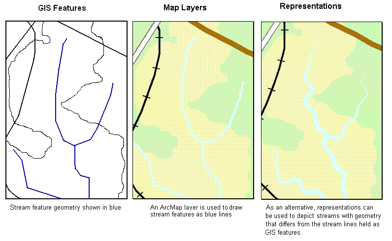
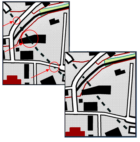
In the example above, you can see the geographic features for roads and how their cartographic representations in the map differ from the GIS feature geometry.
Cartographic representations provide more control and precision, as well as more freedom, for how features are portrayed on the map.At the simplest level, cartographic representations add advanced drawing options for map layers. In addition, these representation rules and overrides are saved with the individual features in the geodatabase for sharing and re-use.
Below, you can see an example for how representations can be used to depict features differently from their feature geometry.
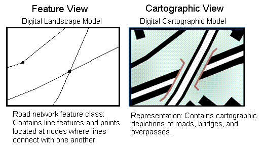
Cartographers often say that there are two views of geographic information -- the geographic view and the cartographic view. In the research literature, the geographic view is sometimes referred to as a digital landscape model in which features are accurately referenced to real-world coordinates and faithfully overlay image sources such as an orthophoto base. The cartographic view is referred to as a digital cartographic model in which map symbols and depictions are the primary means for communication and do not necessarily represent their real-world locations.
In maps, it's often more important to portray how features are placed relative to one another and to graphically communicate a set of relationships (such as the water goes under the bridge). This often requires a cartographic depiction that differs from the real-world location and shape of GIS features.
In ArcGIS, cartographic representations enable both digital models to be integrated in the geodatabase. Cartographic representations are stored as extra columns in the feature class attribute table and in system tables in the geodatabase. Also, you can have multiple cartographic representations for a single feature class. For example, you might have two sets of road representations -- one for transportation maps and another for tourist maps.
This means that you can have multiple cartographic representations for features without changing their underlying feature geometry (point, line, polygon, etc.).
NOTE: Throughout ArcGIS, we simplify the term "cartographic representations" as representations for convenience.
Representation examples
Cartographic representations are intended to handle a multitude of map depiction and portrayal issues in a GIS. Here are a few examples:
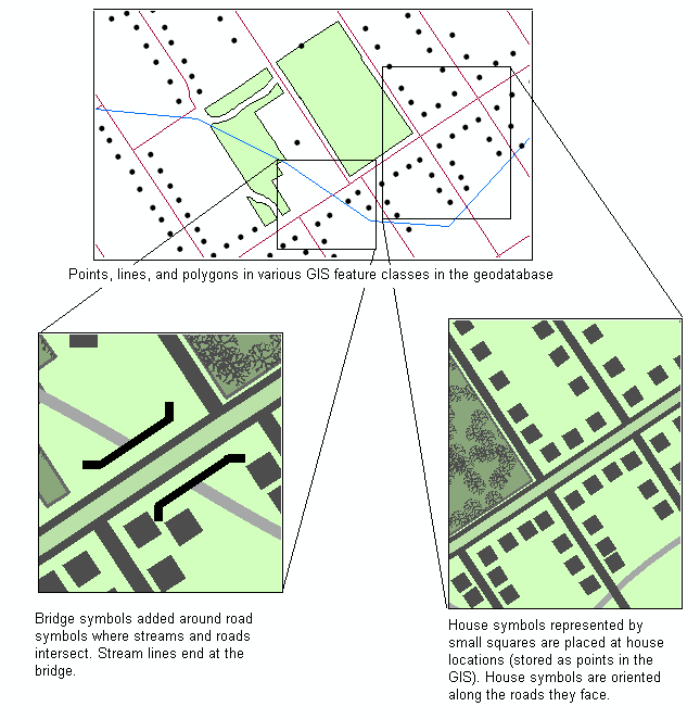
- Streams, bridges, and houses can be portrayed more flexibly.
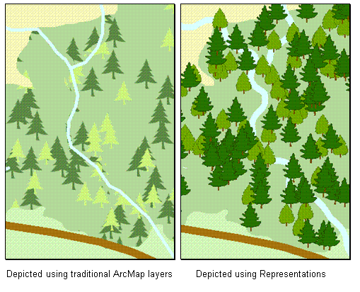
- Standard symbology creates a flat depiction with tree symbols clipped unnaturally at the edges of the feature. Using a representation geometric effect, the polygons dictating where the trees will be drawn can be dynamically shifted to create a more natural depiction as shown below:
- Suppose you would like to represent the real-world configuration of your roads -- bridges, overpasses, underpasses, tunnels and so forth. Further suppose that you also want to model the geographic network of connected edges for routing, tracing and so forth. Cartographic representations enable you to maintain both your GIS feature geometry as well as their cartographic depictions. Further, imagine that you also need to have a tourist road map drawn at a smaller scale yet created using the same GIS road features. You can use an additional representation class to add and manage the road representations for the depictions of roads in the tourist map.
- Imagine that you would like to set a rule to rotate symbols so that they follow along the angle of selected features -- such as rotation of an orchard or crop fill pattern to follow the orientation of each field polygon or to rotate building polygon symbols to align themselves along roads.
- Imagine that you want to create a commuter map that contains multiple lines to represent each route as well as information about transfers you can make at each station. Suppose that the underlying GIS feature geometry is represented by a single set of lines between stations, each of which is represented in the GIS as a single junction point. You need this GIS network model to perform routing and connectivity analysis. However, you also need the cartographic representations for mapping purposes.
- When creating maps, you assign symbols to features and display them automatically using map layers. Often the symbol size exaggerates the size of the feature portrayal compared to its GIS location and feature geometry. This can cause conflicts with the map depictions of other features. For example, road symbols on maps typically are much wider than the road actually is on the ground. The cartographic symbols used to portray road features and the buildings adjacent to the roads may overlap even though their GIS feature geometry does not.
Some mechanism is required in the mapping system that will allow you to handle these situations without affecting the underlying GIS feature geometry.
Cartographic finishing and editing
In addition to applying drawing rules and overrides to depict such mapping situations, you can also graphically edit representations to create high quality map products. Cartographers often refer to this work as "map finishing and editing". Traditionally, they have exported their GIS maps into a graphics package such as Adobe Illustrator to complete such work.
Representations in ArcMap also include a series of tools to perform graphical edits directly in the GIS without having to export the cartography to a graphics package. Here is one simple example that illustrates how dashed line graphics that represent the pathway of a tunnel need to be edited and cleaned up where they intersect buildings and roads:
Since these edits are saved in the geodatabase, they can be delivered to all ArcGIS users in map documents and map servers.
The mapping process in ArcMap
You can think of the use of representations in ArcMap as an optional part of a mapping workflow:
- Create map layers and choose your symbolization, rendering, and labeling options. This will automate much of your cartographic work. The map layer graphics will be automatically created for you using the GIS feature geometry.
- Where needed, use representations to automatically apply rules and overrides to a map layer. These rules can automatically identify a subset of features to which the rules are applied. For example, you can use rules to:
- Rotate buildings that fall within a certain distance of roads so that they are oriented along the roads
- Depict bridges over streams
- Draw endcaps on dead-end roads and cul-de-sacs
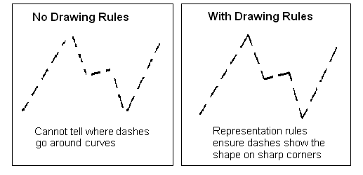
- Set rules for more effectively depicting dashed lines as shown below
- Check for graphic conflicts.
- Select and apply effects and overrides to individual features (e.g., to deal with feature conflicts).
- Perform cartographic edits to selected features to finish your map (e.g., reshape a few selected buildings, erase some of the graphics from selected layer displays, edit graphical conflicts where symbols overlap, etc.)
For more information on representations
See using cartographic representations for more information.