Geoprocessing tool reference > Spatial Statistics toolbox > Mapping Clusters toolset > Tools
Hot Spot Analysis with Rendering (Spatial Statistics) |
|
|
Release 9.2
Last modified January 9, 2009 |


Print all topics in : "Tools" |
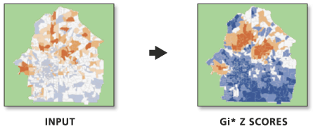
Calculates Gi* statistics and applies a cold-to-hot type of rendering to the output z scores.
Illustration
Usage tips
-
The Gi* rendered model combines the functions Hot Spot Analysis and Z Score Rendering.
-
This tool is appropriate for rendering output from the Collect Events tool.
-
Current map layers may be used to define the input feature class. When using layers, only the currently selected features are used in the Getis-Ord Gi* operation.
-
This tool will only work on the windows operating system. If you are not using windows, please run the Hot Spot Analysis tool by itself.
-
The following environment settings affect this tool: Cluster Tolerance, Extent, M Domain, Configuration Keyword, Coordinate System, Output has M Values, Output Spatial Grid, Output has Z Values, Default Z Value, Output XY Domain, and Output Z Domain.
Command line syntax
An overview of the Command Line window
HotSpotsRendered_stats <Input_Feature_Class> <Input_Field> <Output_Layer_File> <Output_Feature_Class> <Distance_Band_or_Threshold_Distance>
| Parameter | Explanation | Data Type |
| <Input_Feature_Class> |
The feature class for which hot spot analysis will be performed. |
Feature Layer |
| <Input_Field> |
The numeric count field (number of victims, crimes, jobs, and so on) to be evaluated. |
Field |
| <Output_Layer_File> |
The layer file to store the cold-to-hot rendering information. You must include the .lyr extension as part of the file name. |
Layer File |
| <Output_Feature_Class> |
The output feature class to receive the results field and Gi z score. |
Feature Class |
| <Distance_Band_or_Threshold_Distance> |
Specifies a distance cutoff value. Features outside the specified Distance Band or Threshold Distance are ignored in the hot spot analysis. The value entered for this parameter should be in the units of the Input Feature Class' coordinate system. There is one exception. If the Output Coordinate System environment variable is set, the value entered for this parameter should be in the units of the coordinate system set in that environment.A value of zero indicates that no threshold distance is applied. This is only valid with the "Inverse Distance" and "Inverse Distance Squared" spatial conceptualizations.This parameter has no effect when "Polygon Contiguity" and "Get Spatial Weights From File" spatial conceptualizations are selected. |
Double |
Command line example
workspace e:\project93\data
HotSpotsRendered tracts.shp AGE_65_UP tract65hot.lyr tracts65.shp
Scripting syntax
About getting started with writing geoprocessing scripts
HotSpotsRendered_stats (Input_Feature_Class, Input_Field, Output_Layer_File, Output_Feature_Class, Distance_Band_or_Threshold_Distance)
| Parameter | Explanation | Data Type |
| Input_Feature_Class (Required) |
The feature class for which hot spot analysis will be performed. |
Feature Layer |
| Input_Field (Required) |
The numeric count field (number of victims, crimes, jobs, and so on) to be evaluated. |
Field |
| Output_Layer_File (Required) |
The layer file to store the cold-to-hot rendering information. You must include the .lyr extension as part of the file name. |
Layer File |
| Output_Feature_Class (Required) |
The output feature class to receive the results field and Gi z score. |
Feature Class |
| Distance_Band_or_Threshold_Distance (Required) |
Specifies a distance cutoff value. Features outside the specified Distance Band or Threshold Distance are ignored in the hot spot analysis. The value entered for this parameter should be in the units of the Input Feature Class' coordinate system. There is one exception. If the Output Coordinate System environment variable is set, the value entered for this parameter should be in the units of the coordinate system set in that environment.A value of zero indicates that no threshold distance is applied. This is only valid with the "Inverse Distance" and "Inverse Distance Squared" spatial conceptualizations.This parameter has no effect when "Polygon Contiguity" and "Get Spatial Weights From File" spatial conceptualizations are selected. |
Double |
Data types for geoprocessing tool parameters
Script example
# Perform Hot Spot Analysis for assault incidents

# Import system modules
import arcgisscripting

# Create the Geoprocessor object
gp = arcgisscripting.create()

# Local variables...
workspace = "C:/project93/data"
input = "assaults.shp"
collect_output = "collect_output.shp"
collect_count_field = "Count"
hotspot_output = "hotspot_output.shp"
hotspot_output_rendered = "hotspot_output_rendered.lyr"

try:
    # Set the current workspace (to avoid having to specify the full path to the feature classes each time)
    gp.workspace = workspace

    # Convert assault incidents into weighted point data
    # Process: Collect Events...
    gp.CollectEvents_stats(input, collect_output)

    # Calculate Getis-Ord Gi* statistic and render
    # Process: Hot Spot Analysis with Rendering...
    gp.HotSpotsRendered_stats(collect_output, collect_count_field, hotspot_output_rendered, hotspot_output)

except:
    # If an error occurred when running the tool, print out the error message.
    print gp.GetMessages()