Geoprocessing tool reference > Spatial Statistics toolbox > Utilities toolset > Tools
Count Rendering (Spatial Statistics) |
|
|
Release 9.2
Last modified January 9, 2009 |


Print all topics in : "Tools" |
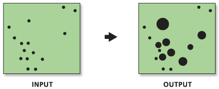
Applies graduated circle rendering to a count type field of a point feature class.
Illustration
Usage tips
-
The Count Renderer draws quantities using circle size to show relative values.
-
By rendering features quantitatively, the point renderer displays potential patterns in the input count data.
-
This tool is appropriate for rendering output from the Collect Events tool.
-
Current map layers may be used to define the input feature class. When using layers, only the currently selected features are used in the Count Renderer operation.
-
This tool will only work on the windows operating system.
-
The environment settings do not affect this tool.
Command line syntax
An overview of the Command Line window
CountRenderer_stats <Input_Feature_Class> <Field_to_Render> <Output_Layer_File> <Number_of_Classes> <mango | bright_red | dark_green | green | dark_blue | bright_pink | light_yellow | sky_blue> {Maximum_Field_Value}
| Parameter | Explanation | Data Type |
| <Input_Feature_Class> |
The feature class containing count data to be rendered. |
Feature Layer |
| <Field_to_Render> |
The name of the field containing count data. |
Field |
| <Output_Layer_File> |
The output layer file to store rendering information. You must include the .lyr extension as part of the file name. |
Layer File |
| <Number_of_Classes> |
The number of classes into which the input feature class will be classified. |
Long |
| <mango | bright_red | dark_green | green | dark_blue | bright_pink | light_yellow | sky_blue> |
The color of the graduated circles. |
String |
| {Maximum_Field_Value} |
The maximum attribute value that will be rendered. Features with field values greater than this maximum value will not be drawn. |
Double |
Command line example
workspace e:\project93\data
CollectEvents assaults.shp assaults_weight.shp
CountRenderer assaults_weight.shp COUNT assaults.lyr 8 bright_red #
Scripting syntax
About getting started with writing geoprocessing scripts
CountRenderer_stats (Input_Feature_Class, Field_to_Render, Output_Layer_File, Number_of_Classes, Symbol_Color, Maximum_Field_Value)
| Parameter | Explanation | Data Type |
| Input_Feature_Class (Required) |
The feature class containing count data to be rendered. |
Feature Layer |
| Field_to_Render (Required) |
The name of the field containing count data. |
Field |
| Output_Layer_File (Required) |
The output layer file to store rendering information. You must include the .lyr extension as part of the file name. |
Layer File |
| Number_of_Classes (Required) |
The number of classes into which the input feature class will be classified. |
Long |
| Symbol_Color (Required) |
The color of the graduated circles. |
String |
| Maximum_Field_Value (Optional) |
The maximum attribute value that will be rendered. Features with field values greater than this maximum value will not be drawn. |
Double |
Data types for geoprocessing tool parameters
Script example
# Convert incident data to weighted point data and render

# Import system modules
import arcgisscripting, sys, string, os

# Create the Geoprocessor object
gp = arcgisscripting.create()

# Local variables...
workspace = "C:/project93/data/"
input = "AutoTheft.shp"
input_weighted = "autotheft_weighted.shp"
results_field = "Count"
input_weighted_rendered = "auto_weight_rendered.lyr"

try:
    # Set the current workspace (to avoid having to specify the full path to the feature classes each time)
    gp.workspace = workspace

    # Process: Collect Events...
    gp.CollectEvents_stats(input, input_weighted, results_field)

    # Process: Count Rendering...
    gp.CountRenderer_stats(input_weighted, results_field, input_weighted_rendered, "5", "mango", "#")

except:
    # If an error occurred when running the tool, print out the error message.
    print gp.GetMessages()