Show Navigation
|
Hide Navigation
You are here:
Geoprocessing tool reference > Environment Settings > Raster Analysis settings
Geoprocessing tool reference > Environment Settings > Raster Analysis settings
Mask |
|
|
Release 9.2
Last modified September 4, 2007 |


Print all topics in : "Raster Analysis settings" |
Related Topics
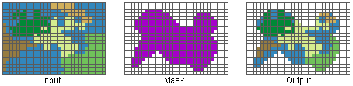
Identifies those cells within the analysis extent that will be considered when performing an operation or a function. Setting an analysis mask means that processing will only occur on selected locations and that all other locations will be assigned values of NoData.
Setting an analysis mask is a three-step process:
- An analysis mask must first be created if you do not already have one. It can be a raster or a feature class dataset.
- If the analysis mask is a raster, all cells of interest have a value, and all other cells have a value of NoData. Only cells with values will be considered in the analysis. The Reclassify tool can help create a raster analysis mask.
- If the analysis mask is a feature dataset, only locations containing features will be considered in the analysis.
Illustration
Usage tips
- The keyword used at the command line or in scripts for this environment setting is Mask.
- Rather than creating the mask based on attributes, you can specify a spatial boundary as the mask. Create a new feature dataset (in ArcCatalog) and digitize the spatial boundary in ArcMap.
-
Learn more about masking
-
Learn more about specifying raster analysis settings
-
Learn more about environment settings
-
Learn more about environment levels and hierarchy
Command line syntax
An overview of the command line window
Mask <raster_dataset>
| Parameters | Explanation | Datatype |
| <raster_dataset> | A raster dataset in which all cells of interest have a value, and all other cells have a value of NoData. | Raster Dataset |
Data types for geoprocessing tool parameters
Command line example
Mask H:\Tongass\oldgrowgrid
Scripting syntax
An overview of scripting in geoprocessing
Mask (raster_dataset)
| Parameters | Explanation | Datatype |
| raster_dataset (Required) | A raster dataset in which all cells of interest have a value, and all other cells have a value of NoData. | Raster Datatset |
Data types for geoprocessing tool parameters
Script example
import arcgisscripting
gp = arcgisscripting.create()

gp.workspace = "h:/workspace"
gp.toolbox = "SA"
gp.Mask = "H:/Tongass/oldgrowgrid"