Data support in ArcGIS > CAD data > Georeferencing CAD data
World files |
|
|
Release 9.2
Last modified August 15, 2007 |


Print all topics in : "Georeferencing CAD data" |
About world files
World files are used to define a two-point (similarity) transformation for CAD datasets in ArcGIS. They contain the source (from) and destination (to) coordinate values of a transformation and can be managed in ArcMap. World files are not required to transform CAD datasets, since interactive transformation tools exist in ArcMap. However, world files can help streamline the transformation process. The following section provides detailed information about how you can work with world files in ArcGIS.
The world file structure
A world file is a text file (.wld) containing one or four pairs of x,y coordinates. The first pair of coordinates is the x,y location of any known control point in your drawing file. The second pair of x,y coordinates is a new location in geographic space where you want the CAD drawing control point to be in ArcMap. These coordinates comprise the first point of the two-point transformation. The remaining pairs of coordinates follow the same structure as the first and second pairs. They make up the second point of the two-point transformation.
The world file format is as follows:
| x,y location in CAD drawing | space | {x,y location in geographic space} |
| <From X1,From Y1> |
|
<To X1,To Y1> |
| <From X2,From Y2> |
|
<To X2,To Y2> |
Here is an example of the contents of a world file:
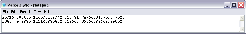
26315.299650,11063.153340 519481.78700,94276.547000
28854.942990,11110.990860 519505.85500,93502.99800
Here is an example of the contents of a world file viewed in Notepad:
The world file must have the .wld extension and cannot have more than two lines in the above format. ArcMap automatically applies the world file when it finds a valid world file name with the same prefix as the drawing file name in the same folder. For example, suppose you've stored sample.dwg and sample.wld files in the same folder. When you add layers from sample.dwg, ArcMap automatically uses the sample.wld file for coordinate transformations.
Saving a world file
Once a transformation has been defined for a CAD layer, you can save the transformation to a world file. The from and to coordinate values that defined the CAD transformation will be saved to a world file when you click the Update Georeferencing command.
If a world file already exists for the target CAD dataset, you will be prompted to overwrite the file when attempting to save the world file.
Prior to executing the Update Georeferencing command, you can save your control point coordinates to a world file by clicking the Link Table Save button. This will open a Save As dialog box and allow you to browse to a folder and name the world file (although the world file will default to the CAD dataset's name).
Loading a world file
You can load a world file into the current ArcMap session to define a CAD transformation. The coordinate values in the world file will be translated into control points. If control points already exist in the map, loading coordinate values from a world file will overwrite the existing ones.
How to save and load world files
Saving world files
- Click the Link Table button on the Georeferencing toolbar.
The Link Table dialog box appears. - Click the Save button to save the control point coordinates to a world file.
- Specify a name and location of the world file.
To associate a world file with a CAD dataset, you must use the CAD dataset's prefix name and place it in the same folder where the CAD drawing resides. - Click OK.
Creating a universal world file
- Click the Link Table button on the Georeferencing toolbar.
The Link Table dialog box appears. - Click the Save button to save the control points to a world file.
- Specify esri_cad.wld as the name for the world file.
- Click OK.
| Tip |
|
The universal world file is for defining a transformation for all CAD drawings in a workspace. esri_cad.wld will apply to all CAD drawings in that folder, which do not already have a world file designated. If one exists for a specific CAD drawing it will override the esri_cad.wld file. |
Loading world files
- Click the Link Table button on the Georeferencing toolbar.
The Link Table dialog box appears. - Click the Load button to load an existing world file.
The coordinate values of the world file will populate the Link Table. - Click OK.