Data support in ArcGIS > Coverages
What is a coverage |
|
|
Release 9.2
Last modified February 6, 2007 |


Print all topics in : "Coverages" |
A coverage is a georelational data model that stores vector data—it contains both the spatial (location) and attribute (descriptive) data for geographic features. Coverages use a set of feature classes to represent geographic features. Each feature class stores a set of points, lines (arcs), polygons, or annotation (text). Coverages can have topology, which determines the relationships between features.
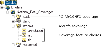
A coverage is stored as a directory within which each feature class is stored as a set of files. For example, a coverage will appear in ArcCatalog with the icons as shown below. In this example, you can see that the streams coverage is a line coverage containing an arc (line) file, annotation for the line, and a tic file. There are also two versions of coverage files.
Coverage features
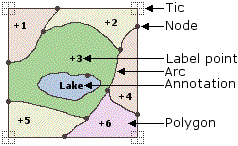
More than one feature class is often required to define the features in a coverage. For example, line and polygon feature classes both exist in a coverage representing polygon features. Polygon features also have label points, which appear as a separate feature class. Every coverage has a feature class containing tic points, which represent known real-world coordinates.These tic points help define the extent of a coverage; they do not represent any actual data points within the coverage. The figure below shows the common feature classes in a coverage. The other coverage feature classes include section, route, region, and link.
For more information about the coverage data model, see How coverages are stored.
Learn about defining a coverage's coordinate system
Feature numbers
A geographic feature in a coverage is identified by a unique feature number. Spatial and attribute data of a feature is linked by means of this number.
| <cover># | An internal sequence number (software assigned) |
| <cover>-ID | A feature ID (user assigned) for which <cover> is the coverage name |
The sequence number (<cover>#) is a number for a record within a file that contains data about features. Sequence numbers, which are automatically generated and maintained, are important for building topology lists. They are unique for each feature but do not necessarily remain fixed; they can change as coverages are updated and manipulated.
Feature IDs (<cover>-ID) are also generated automatically (although they can be changed). In practice, a feature ID is an integer value that you assign to each feature (for example, a polygon). The value should be unique. Feature IDs, sometimes referred to as User-IDs, are often used to relate additional attributes to particular geographic features. For example, related files are sometimes linked to the coverage feature using the feature ID. Changing this value should only be done in Workstation ArcEdit, and both the <cover>-ID and related $ID in the .nit and .dat files must be changed or you will corrupt your data. If you need to make this type of edit, it is best to import your coverage into a geodatabase feature class and make the edits to the feature class.
Feature attributes
Feature attributes are stored in the coverage's .adf files. Other attributes can be stored in INFO tables or tables in an RDBMS, then joined to features with a layer or a relationship class.
When you look in a folder in the Catalog, you see all the coverages and any associated INFO tables it may contain; you don't see the INFO folder itself. Expand a coverage to see its feature classes; each feature class represents both the features and their associated attribute tables. If you select a feature class (such as a polygon), you can preview its features and attributes.
Learn more about previewing geographic data in ArcCatalog
Connecting features and attributes
There are three noteworthy characteristics of the link between the spatial and tabular data:
- The features in the coverage exist in a one-to-one relationship with the corresponding records in the feature attribute table.
- ArcGIS maintains the link between the feature and the attribute record through the unique identifier assigned to each feature. This is the feature's sequence number.
- The feature's sequence number is physically stored in two places for a coverage: in the files containing the locational data for each feature (for example, x,y coordinate pairs) and with the corresponding record in the feature attribute table. ArcGIS automatically creates and maintains this connection.
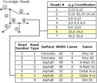
In the figure below, both the coordinate and the attribute records share a common element: the feature's sequence number. The sequence number associates the feature coordinates with the attributes, maintaining a one-to-one correspondence between them. Once this connection is established, you can query the coverage to display attribute information or create a map based on the attributes stored in the feature attribute table.
Learn more about coverage topology
Associated files
Coverages often have associated files. To see them in ArcCatalog, add them as file types. For example, to see ARC Macro Language (AML) scripts, you would add the file extension .aml to the File Types list.
Learn more about viewing file types
Versions of coverages
PC ARC/INFO coverages are similar to ArcInfo coverages, except that their attributes are stored in dBASE tables. PC ARC/INFO coverages can be previewed in ArcCatalog and you can create metadata for them, but other data management operations, such as copy, paste, and delete, are not available.
Coverages created with ArcInfo before version 7 are unavailable in ArcCatalog. After converting the workspace using ArcInfo Workstation, you can access coverages' contents in ArcCatalog.