Mapping and visualization > Using cartographic representations > Getting started with representations
An overview of representations |
|
|
Release 9.2
Last modified August 15, 2007 |


Print all topics in : "Getting started with representations" |
Feature class representations let you store symbology with your features in the geodatabase and edit the appearance of individual features on your maps. Tools to help you manage representations include a new layer symbology option to display layers with a representation, a interface for configuring individual symbols within a representation, and a set of editing tools to modify the appearance of features symbolized with representations.
Representations let you control the appearance of features in a way that previously required exporting your map to a dedicated graphics program. You can now store alternate feature geometry that is used only for symbology, not for processing or analysis. Representation information is stored in geodatabase files. Only geodatabase feature classes can store representations. A single feature class can have multiple representations to support a variety of maps from a single data source.
Symbolizing layers with representations
You can symbolize a layer with a feature class representation using the Representation category in the layer symbology options on the Layer Properties dialog box. The Representation category is listed only for layers whose data sources contain one or more representations. A feature class representation consists of one or more representation rules that define how each type of feature will be depicted. Use the Symbology tab on the Layer Properties dialog box to create, modify, and manage these representation rules. You can also store and share representation rules in styles.
See a layer symbolized with a feature class representation
Learn how to manage representation rules in a style
Converting existing symbology to representations
You can use representations to improve the quality of your existing maps by creating a new feature class representation from a symbolized layer.
This creates a new feature class representation for the layer's data source, translates the current symbology into representation symbology, and optionally adds a new layer to your map symbolized with the new representation.
Learn how to create and manage feature class representations
Learn how to work with feature class representations
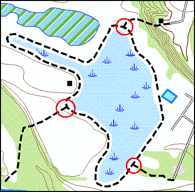
The two images below compare line features in a feature class drawn with a dashed line symbol to line features in a feature class representation drawn with a stroke symbol layer and a dash geometric effect. The red circles indicate places where ambiguous joins have been automatically improved just by symbolizing with a feature class representation.
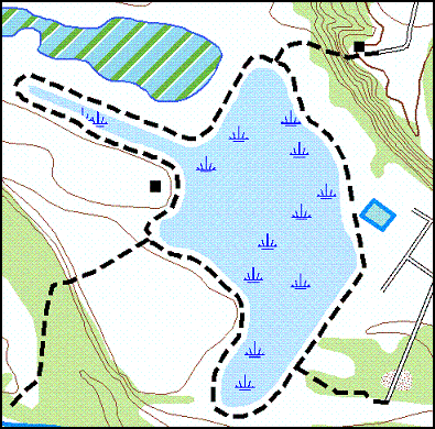
Line features in a feature class drawn with a dashed line symbol:
Line features in a feature class representation drawn with a stroke symbol layer and a dash geometric effect:
Creating representation rules
A representation rule defines how a set of features in a feature class representation will be drawn, using representation symbology geometric effects and marker placement styles. Use the Symbology tab on the Layer Properties dialog box to interact with the individual properties that make up a representation rule. Existing ArcGIS symbols can be converted to representation rules when you create a representation from a symbolized layer.
View the parts of a representation rule
Learn how to work with representation rules
Representation rules are comprised of symbol layers and geometric effects. They work in sequence to define how features appear on your map. Symbol layers are the basic building blocks of the representation rule and can be one of three types: marker, stroke, or fill. A representation rule must have at least one symbol layer but may have many to support complex depictions.
Learn how to work with symbol layers
Geometric effects are optional components of representation rules. They alter the geometry of features dynamically at draw time to achieve the desired appearance without affecting the associated shape of the feature itself. This means that a complex view of the data can be achieved without affecting existing spatial relationships. Geometric effects can apply to just one symbol layer or globally to all symbol layers in a representation rule. Geometric effects work sequentially, so the dynamic result of one becomes the input for the next.
Learn how to work with geometric effects
The components of the symbol layers and the geometric effects in a representation rule make up the representation properties of that representation rule. Their values can be the same for every feature that uses the rule, or they can be read from fields within the data. Geoprocessing tools can be used to populate these fields with meaningful values.
Overriding representation rules
Representations allow exceptions to be made to the representation rule properties in a manageable way to accommodate the rare features whose circumstances warrant a symbol slightly different from other features following the same rule. The rule does not have to be broken or unapplied in this case, just overridden. These changes are stored and maintained in the geodatabase as overrides. Therefore, they will appear on any map that references that representation. Overrides can be modified or removed to revert the feature representation to the representation rule.
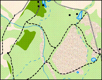
Line features can be symbolized with a dashed stroke representation rule:
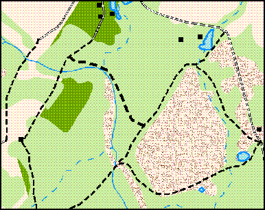
Properties of that rule, such as the stroke weight, can be overriden for individual features without breaking the rule:
Optionally, geometry can also be overridden using representations. Geometry overrides allow you to modify the appearance of feature geometry on your maps without affecting the geometry source features, which you may be using for analysis or processing. These are persistent edits, different from the dynamic geometry changes that occur at draw time with geometric effects. A set of representation editing tools is provided specifically for making these types of modifications. Representation editing tools are found on the Representation toolbar.
In extreme cases where a feature requires a unique or complex rendering, its representation can be converted into a free representation, which gives you full artistic control of its appearance. A free representation has its own representation rule not associated with any other feature. Therefore, not only can you change the properties of the representation rule, you can also change its structure. Since this means that you can add new symbol layers, you can add new geometry types to this single feature. For example, you can draw a polygon to be associated with a line feature. The definition of the polygon’s shape and size would exist wholly within the line feature’s stored symbology. It would not affect the Shape field of the line.
Managing feature class representations in ArcCatalog
Representation symbology information is stored in system tables in the geodatabase, and is referenced by additional columns in your feature class. Multiple representations can be associated with a single feature class so that the same data can be portrayed uniquely on different map products.

The Representation tab of the Feature Class Properties dialog box in ArcCatalog lists all the feature class's representations and allows you to create new representations, delete existing representations, and import representation rules from other representations.
Learn how to create and manage feature class representations
Learn how to work with feature class representations
Using representation geoprocessing tools
Geoprocessing tools for working with representations are available in the Cartography toolbox in ArcToolbox. These tools require an ArcInfo license.
You can use geoprocessing tools to manage representations, refine the appearance of existing representations, and detect graphical conflicts where representation symbology overlaps, even if the underlying spatial geometry does not.
The Representation toolbar
The Representation toolbar contains the tools you will need to edit feature representations. You must add the Representation toolbar to ArcMap before you can begin editing.
View the Representation toolbar