Extensions > Spatial Analyst > Analysis concepts > Distance analysis
Understanding Euclidean distance analysis |
|
|
Release 9.2
Last modified May 2, 2007 |


Print all topics in : "Distance analysis" |
The Euclidean distance functions describe each cell's relationship to a source or a set of sources.
There are three Euclidean functions:
- Euclidean Distance gives the distance from each cell in the raster to the closest source. Example of usage: What is the distance to the closest town?
- Euclidean Allocation identifies the cells that are to be allocated to a source based on closest proximity. Example of usage: What is the closest town?
- Euclidean Direction gives the direction from each cell to the closest source. Example of usage: What is the direction to the closest town?
Learn how to calculate Euclidean (straight line) distance and direction using the Spatial Analyst toolbar
Learn how to calculate Euclidean (straight line) allocation using the Spatial Analyst toolbar
Learn how to calculate Euclidean distance using the Euclidean Distance tool
Learn how to calculate Euclidean direction using the Euclidean Direction tool
Learn how to calculate Euclidean allocation using the Euclidean Allocation tool
The input raster used in each of the Euclidean functions and a discussion about the output from the functions is described below.
The source
The source identifies the location of the objects of interest, such as wells, shopping malls, roads, and forest stands. If the source is a raster, it must contain only the values of the source cells while other cells must be NoData. If the source is a feature, it will internally be transformed into a raster when you run the function.
The Euclidean distance output raster
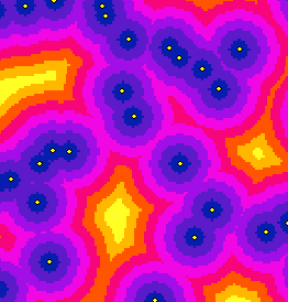
The Euclidean distance output raster contains the measured distance from every cell to the nearest source. The distances are measured as the crow flies (Euclidean distance) in the projection units of the raster, such as feet or meters and are computed from cell center to cell center.
The Euclidean Distance function is used frequently as a standalone function for applications, such as finding the nearest hospital for an emergency helicopter flight. Alternatively, this function can be used when creating a suitability map, when data representing the distance from a certain object is needed.
In the example below, the distance to each town is identified. This type of information could be extremely useful for planning a hiking trip. You may want to stay within a certain distance of a town in case of emergency or know how much farther you have to travel to pick up supplies.
The Euclidean allocation output raster
Every cell in the Euclidean allocation output raster is assigned the value of the source to which it is closest. The nearest source is determined by the Euclidean Distance function. Use this function to assign space to objects such as identifying the customers served by a group of stores. In the example below, the Euclidean Allocation function has identified the town that is closest to each cell. This could be valuable information if you needed to get to the nearest town from a remote location.

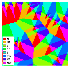
The Euclidean direction output raster
The Euclidean direction output raster contains the azimuth direction from each cell to the nearest source. The directions are measured in degrees, where north is 360 degrees.
In the example below, the direction to the nearest town is found from every location. This could provide useful information for an emergency helicopter when transporting an injured hiker to the nearest town for medical treatment.
The Euclidean Distance functions give you information according to Euclidean, or straight-line, distance. It may not be possible to travel in a straight line to a specific location; you may have to avoid obstacles such as a river or a steep slope. In such cases, you should consider using the Cost Distance function to achieve more realistic results.
Learn more about understanding cost distance analysis