Editing and data compilation > Getting started with editing
The sketch construction tools |
|
|
Release 9.2
Last modified August 17, 2007 |


Print all topics in : "Getting started with editing" |
When you want to create new features or a sketch, you'll use the tools on the Editor toolbar tool palette. The Sketch tool is the tool you will use most often to create a sketch.
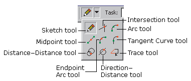
These tools can be used by themselves or in conjunction with each other to create new features or sketches.
The Sketch tool and the other tools on the tool palette are described below.
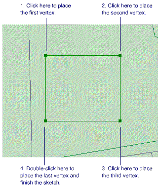
Sketch tool
Use the Sketch tool ![]() to create point features and digitize the vertices of line or polygon features. After you finish the sketch, ArcMap adds the final segment, and the sketch turns into a feature.
to create point features and digitize the vertices of line or polygon features. After you finish the sketch, ArcMap adds the final segment, and the sketch turns into a feature.
Arc tool
The Arc tool ![]() helps you create a segment that is a parametric (true) curve. Instead of being made of numerous vertices, a parametric curve has only two vertices as endpoints. You might use the Arc tool to digitize a cul-de-sac, using an aerial photo image as a backdrop.
helps you create a segment that is a parametric (true) curve. Instead of being made of numerous vertices, a parametric curve has only two vertices as endpoints. You might use the Arc tool to digitize a cul-de-sac, using an aerial photo image as a backdrop.
Direction-Distance tool
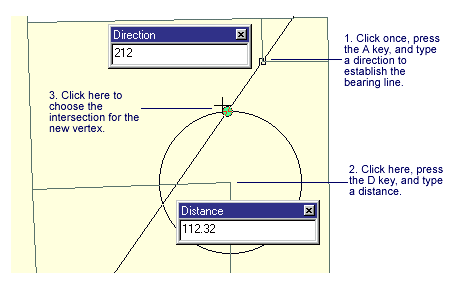
The Direction–Distance tool ![]() allows you to create a vertex using a distance from a known point plus a direction from a known point to define a bearing line. For example, a pole might be located at a specified distance from the corner of one building and at a defined angle from the corner of another building.
allows you to create a vertex using a distance from a known point plus a direction from a known point to define a bearing line. For example, a pole might be located at a specified distance from the corner of one building and at a defined angle from the corner of another building.
Distance-Distance tool
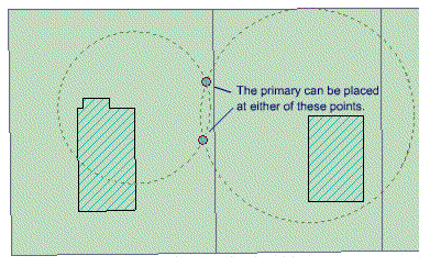
The Distance–Distance tool ![]() lets you create a point or vertex at the intersection of two distances from two other points.
lets you create a point or vertex at the intersection of two distances from two other points.
In the example below, the Distance–Distance tool is used to place a new electrical primary based on field measurements. The next point for the primary is known to be 50 feet from one building corner and 75 feet from another. The Distance–Distance tool creates two circles based on these distances and finds two possible intersection points where the primary can be placed.
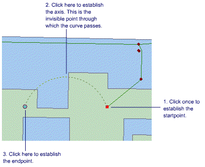
Endpoint Arc tool
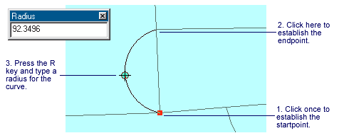
The Endpoint Arc tool ![]() allows you to specify the start and endpoints of the curve, then define a radius for the curve. This is particularly useful in sketching cul-de-sacs, where the beginning and ending points of the arc, as well as the radius of the cul-de-sac, are known.
allows you to specify the start and endpoints of the curve, then define a radius for the curve. This is particularly useful in sketching cul-de-sacs, where the beginning and ending points of the arc, as well as the radius of the cul-de-sac, are known.
Intersection tool
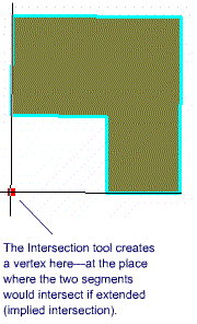
The Intersection tool ![]() creates a point or vertex at the place where two segments would intersect if extended far enough.
creates a point or vertex at the place where two segments would intersect if extended far enough.
In the example below, the Intersection tool is used to create a parking lot adjoining an L-shaped building. The outer corner of the lot should be located at the point where the two outermost walls of the building would intersect if they were extended.
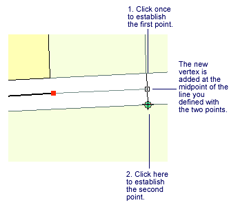
Midpoint tool
The Midpoint tool ![]() lets you define the location of the next vertex by clicking two points; the new vertex is placed at the midpoint of the line between these points. If you were creating a road feature class from parcel data, you might use the Midpoint tool to create the vertices directly between the parcels on opposing sides of the road.
lets you define the location of the next vertex by clicking two points; the new vertex is placed at the midpoint of the line between these points. If you were creating a road feature class from parcel data, you might use the Midpoint tool to create the vertices directly between the parcels on opposing sides of the road.
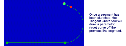
Tangent tool
The Tangent tool ![]() adds a segment that is tangential to the previously sketched segment. This tool is practical when sketching rail lines in which the curves are nearly always tangential to the previous segment.
adds a segment that is tangential to the previously sketched segment. This tool is practical when sketching rail lines in which the curves are nearly always tangential to the previous segment.
NOTE: The Tangent tool can only be used if you have already sketched a segment using one of the other sketch construction tools.
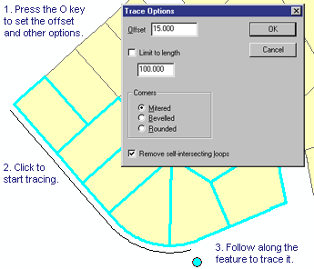
Trace tool
The Trace tool ![]() helps you create segments that follow along existing segments. Suppose you want to add a new road casing feature that is offset 15 feet from the front of a parcel subdivision. You could use the Trace tool to trace along the existing line features instead of typing the angle and length of each segment. You'll need to select the parcel features before you can start tracing the road casing feature. The Trace tool only follows selected features.
helps you create segments that follow along existing segments. Suppose you want to add a new road casing feature that is offset 15 feet from the front of a parcel subdivision. You could use the Trace tool to trace along the existing line features instead of typing the angle and length of each segment. You'll need to select the parcel features before you can start tracing the road casing feature. The Trace tool only follows selected features.