Extensions > Spatial Analyst > Spatial Analyst functional reference > Generalization (Spatial Analyst)
Nibble |
|
|
Release 9.2
Last modified January 3, 2008 |


Print all topics in : "Generalization (Spatial Analyst)" |
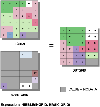
Replaces cells of a raster corresponding to a mask with the values of the nearest neighbors.
Learn more about how Nibble works
Illustration
Usage tips
-
The input raster and input raster mask must be integers.
-
Cells in the input raster containing NoData are not nibbled. To nibble NoData, convert it to another value.
-
The following environment settings affect this tool:
- General: Current Workspace, Scratch Workspace, Output Coordinate system, Output Extent (and Snap Raster).
- Raster Analysis: Cell size, Mask.
- Raster Storage: See the Raster Storage settings for the particular output raster format selected.
-
The <in_grid> and <mask_grid> must be integer rasters.
-
Cells in the <in_grid> containing NoData are not nibbled. To nibble NoData, convert it to another value.
-
Learn more about how to specify the input raster dataset in the Map Algebra expression of Raster Calculator.
-
The input raster and maskRaster must be integer.
-
Cells in the input raster that are NoData are not nibbled. To nibble NoData, convert it to another value.
-
The output from the ArcObjects method is a raster object.
Command line and Scripting
Map Algebra
ArcObjects
Command line syntax
An overview of the Command Line window
Nibble_sa <in_raster> <in_mask_raster> <out_raster> {ALL_VALUES | DATA_ONLY}
| Parameter | Explanation | Data Type |
| <in_raster> |
Input raster. |
Composite Geodataset |
| <in_mask_raster> |
The raster used as the mask. Cells with NoData as their value will be nibbled in the in_raster. |
Composite Geodataset |
| <out_raster> |
The raster to be created. |
Raster Dataset |
| {ALL_VALUES | DATA_ONLY} |
Keywords defining if NoData values in the in_raster are allowed to nibble into the area defined by the in_mask_raster.
|
Boolean |
Command line example
Nibble_sa C:/data/ras_1 C:/data/mask_1 C:/data/final_1 ALL_VALUES
Scripting syntax
About getting started with writing geoprocessing scripts
Nibble_sa (in_raster, in_mask_raster, out_raster, nibble_values)
| Parameter | Explanation | Data Type |
| in_raster (Required) |
Input raster. |
Composite Geodataset |
| in_mask_raster (Required) |
The raster used as the mask. Cells with NoData as their value will be nibbled in the in_raster. |
Composite Geodataset |
| out_raster (Required) |
The raster to be created. |
Raster Dataset |
| nibble_values (Optional) |
Keywords defining if NoData values in the in_raster are allowed to nibble into the area defined by the in_mask_raster.
|
Boolean |
Data types for geoprocessing tool parameters
Script example
# Nibble_sample.py
# Description:
#   Replaces cells of a raster corresponding to a mask, with the
#   values of the nearest neighbors.
# Requirements: None
# Author: ESRI
# Date: Sept 6, 2005

# Import system modules
import arcgisscripting

# Create the Geoprocessor object
gp = arcgisscripting.create()

try:
    # Set local variables
    outRaster = "C:/data/final_1"
    inRaster = "C:/data/ras_1"
    maskRaster = "C:/data/mask_1"

    # Check out Spatial Analyst extension license
    gp.CheckOutExtension("Spatial")

    # Process: Majority Filter...
    gp.Nibble_sa(filter, maskRaster, outRaster, "ALL_VALUES")

except:
    # If an error occurred while running a tool, then print the messages.
    print gp.GetMessages()
Map Algebra syntax
Nibble(<in_grid>, <mask_grid>, {ALL | DATAONLY})
| Parameter | Explanation |
| <in_grid> | The name of a raster. |
| <mask_grid> | The name of a raster used as the mask.
Cells with NoData as their value will be nibbled in the <in_grid>. |
| {ALL | DATAONLY} | Keywords defining if NoData values in the <in_grid> are allowed to nibble into the area defined by the <mask_grid>.
|
Map Algebra example
nibble(inputgrid, maskgrid)
ArcObjects syntax
IGeneralizeOp::Nibble (raster As IGeoDataset, maskRaster As IGeoDataset, useNoData As Boolean) As IGeoDataset
| Parameter | Explanation |
| raster | The name of a raster. |
| maskRaster | The name of a raster used as the mask.
Cells with NoData as their value will be nibbled in the first input raster. |
| useNoData | Boolean defining if NoData values in the raster are allowed to nibble into the area defined by the maskRaster.
If True, the nearest neighbor value will be used whether it is NoData or another data value in the first input raster. NoData values in the first input raster are free to nibble into areas defined in the maskRaster if they are the nearest neighbor. If False, only data values are free to nibble into areas defined in the maskRaster. NoData values in the first input raster are not allowed to nibble into areas defined in the maskRaster even if they are the nearest neighbor. |
ArcObjects example
' Create the GeneralizeOp object
Dim pGeneralizeOp As IGeneralizeOp
Set pGeneralizeOp = New RasterGeneralizeOp

' Create the input raster object
Dim pInputDataset As IGeoDataset

' Calls function to open the input raster dataset from disk
Set pInputDataset = OpenRasterDataset ("D:\SpatialData", "inputraster")

' Create the input mask raster object
Dim pMaskDataset As IGeoDataset

' Calls function to open the mask raster dataset from disk
Set pMaskDataset = OpenRasterDataset ("D:\SpatialData", "maskraster")

' Create the output dataset object
Dim pOutputDataset As IGeoDataset

' Calls the method
Set pOutputDataset = pGeneralizeOp.Nibble (pInputDataset, pMaskDataset)