Extensions > Spatial Analyst > Spatial Analyst functional reference > Generalization (Spatial Analyst)
Shrink |
|
|
Release 9.2
Last modified January 3, 2008 |


Print all topics in : "Generalization (Spatial Analyst)" |
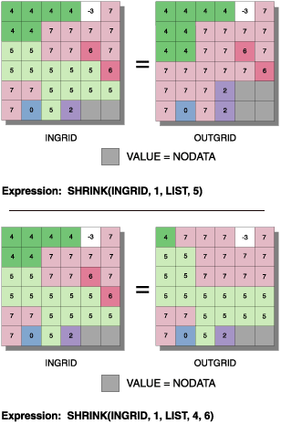
Shrinks the selected zones by a specified number of cells.
Learn more about how Shrink works
Illustration
Usage tips
-
The input raster must be an integer raster.
-
The number of cells must be a positive integer.
-
The zone values must be integers. They can be in any order.
-
When two adjacent regions are part of the selected set to shrink, there is no change at the boundary between them.
-
NoData has the same priority as any valid value to invade areas vacated by shrinking selected values. Therefore, if a selected value is adjacent to NoData, it may become NoData after shrinking.
-
The following environment settings affect this tool:
- General: Current Workspace, Scratch Workspace, Output Coordinate system, Output Extent (and Snap Raster).
- Raster Analysis: Cell size, Mask.
- Raster Storage: See the Raster Storage settings for the particular output raster format selected.
-
The <in_grid> must be an integer raster, and <ncells> and all values within the LIST, FILE, or TABLE must be integer.
-
The zone values in an ASCII FILE or INFO TABLE must be sorted in ascending order.
-
The ASCII file used with the FILE option can be one column or two. A one-column file indicates single values will be specified for selection. A two-column file indicates ranges of values will be specified for selection. For example: To select cells with value 1 and 5, the FILE would be:
   1
   5
To select cells with a value between 1 and 5, inclusively, the FILE would be:1 5
-
The INFO table used with the TABLE option selects only single values from the {item} specified.
-
When two adjacent regions are part of the selected set to Shrink, there is no change at the boundary between them.
-
NoData has the same priority as any valid value to invade areas vacated by the shrink of selected values. Therefore, if a selected value is adjacent to NoData, it may become NoData following Shrink.
-
Learn more about how to specify the input raster dataset in the Map Algebra expression of Raster Calculator.
-
Valid input for the raster to ArcObjects is a Raster, RasterDataset, RasterBand, or RasterDescriptor.
-
The input raster must be integer.
-
The numberCells input must be integer.
-
A zoneList is used to specify the zones to shrink. A zoneList can be created using the following code:
   Dim ZoneList As Variant
   Dim ZoneArr(0 to 2) as Integer
   ZoneArr(0) = 860
   ZoneArr(1) = 880
   ZoneArr(2) = 1000
   ZoneList = ZoneArr()
-
When two adjacent regions are part of the selected set to shrink, there is no change at the boundary between them.
-
NoData has the same priority as any valid value to invade areas vacated by the shrink of selected values. Therefore, if a selected value is adjacent to NoData, it may become NoData following Shrink.
-
The output from the ArcObjects method is a raster object.
Command line and Scripting
Map Algebra
ArcObjects
Command line syntax
An overview of the Command Line window
Shrink_sa <in_raster> <out_raster> <number_cells> <zone_values; zone_values...>
| Parameter | Explanation | Data Type |
| <in_raster> |
Input raster. |
Composite Geodataset |
| <out_raster> |
The raster to be created. |
Raster Dataset |
| <number_cells> |
The number of cells by which to shrink each specified zone. |
Long |
| <zone_values; zone_values...> |
List of zone values to shrink. |
Long |
Command line example
Aggregate_sa C:/data/ras_1 C:/data/final_1 1 2
Scripting syntax
About getting started with writing geoprocessing scripts
Shrink_sa (in_raster, out_raster, number_cells, zone_values)
| Parameter | Explanation | Data Type |
| in_raster (Required) |
Input raster. |
Composite Geodataset |
| out_raster (Required) |
The raster to be created. |
Raster Dataset |
| number_cells (Required) |
The number of cells by which to shrink each specified zone. |
Long |
| zone_values (Required) |
List of zone values to shrink. |
Long |
Data types for geoprocessing tool parameters
Script example
# Shrink_sample.py
# Description:
#   Thins rasterized linear features by reducing the number of
#   cells representing the width of the features.
# Requirements: None
# Author: ESRI
# Date: Sept 6, 2005
# Import system modules
import arcgisscripting

# Create the Geoprocessor object
gp = arcgisscripting.create()

try:
    # Set local variables
    outRaster = "C:/data/final_1"
    inRaster = "C:/data/ras_1"

    # Check out Spatial Analyst extension license
    gp.CheckOutExtension("Spatial")

    # Process: Majority Filter...
    gp.Shrink_sa(inRaster, outRaster, "1", "'2'")

except:
    # If an error occurred while running a tool, then print the messages.
    print gp.GetMessages()
Map Algebra syntax
Shrink(<grid>, <ncells>, LIST, <value_list>)
Shrink(<grid>, <ncells>, TABLE, <select_table>, {item})
| Parameter | Explanation |
| (<grid>, <ncells>, LIST, <value_list>) | The zones to shrink will be listed. |
| (<grid>, <ncells>, FILE, <select_file>) | The zones to shrink will be read from an ASCII file. |
| (<grid>, <ncells>, TABLE, <select_table>, {item}) | The zones to shrink will be read from a specified item in an INFO file. |
| <grid> | The name of a raster. |
| <ncells> | The number of cells by which to shrink each selected zone. |
| LIST | Keyword indicating that the zones to select will be listed on the command line. |
| <value_list> | A listing of values from the value attribute table.
This list can contain no more than 20 values. |
| FILE | Keyword indicating that the zones to select will be listed in an ASCII text file. |
| <select_file> | The name of an ASCII text file containing the value or value ranges from the value attribute table to be selected. |
| TABLE | Keyword indicating that the zones to select will be listed as single values in an INFO file. |
| <select_table> | The name of a table of single values to be selected. |
| {item} | The name of the item in the INFO table from which values in the <select_table> will be selected.
The default is Value. |
Map Algebra example
shrink(ingrid, 1, list, 5)
shrink(ingrid, 2, list, 6, 0, 9, 1)
shrink(ingrid, 4, file, shrfile)
shrink(ingrid, 1, table, shrtable)
ArcObjects syntax
IGeneralizeOp::Shrink (raster As IGeoDataset, numberCells As Long, zoneList As Variant) As IGeoDataset
| Parameter | Explanation |
| raster | An input Raster, RasterDataset, RasterBand, or RasterDescriptor. |
| numberCells | The number of cells by which to shrink each selected zone. |
| zoneList | A listing of zones from the value attribute table. |
ArcObjects example
' Create the RasterGeneralizeOp object
Dim pGeneralizeOp As IGeneralizeOp
Set pGeneralizeOp = New RasterGeneralizeOp

' Declare the input raster object
Dim pInputDataset As IGeoDataset

' Calls function to open a raster dataset from disk
Set pInputDataset = OpenRasterDataset("D:\SpatialData", "inputdataset")

' This example is assuming the input raster is integer
'  type and contains values: 860, 880, 1000 and will be
'  defined in the following zone list
Dim ZoneList As Variant
Dim ZoneArr(0 to 2) as Integer
ZoneArr(0) = 860
ZoneArr(1) = 880
ZoneArr(2) = 1000
ZoneList = ZoneArr()

' Declare the output raster object
Dim pOutputRaster As IGeoDataset

' Calls the method
Set pOutputRaster = pGeneralizeOp.Shrink(pInputDataset, 3, ZoneList)