Editing and data compilation > Editing existing features
Simplifying and smoothing features |
|
|
Release 9.2
Last modified August 17, 2007 |


Print all topics in : "Editing existing features" |
About simplifying and smoothing features
The Advanced Editing toolbar provides tools to enable you to smooth and simplify features. This includes line and polygon features.
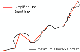
The Generalize tool ![]() simplifies the shape of the selected features using the published algorithm (Douglas and Peucker, 1973). The degree to which the geometry is simplified depends on the maximum allowable offset, which limits how far the output geometry can be from the input geometry. For features composed of linear segments, the output vertices will be a subset of the original feature vertices.
simplifies the shape of the selected features using the published algorithm (Douglas and Peucker, 1973). The degree to which the geometry is simplified depends on the maximum allowable offset, which limits how far the output geometry can be from the input geometry. For features composed of linear segments, the output vertices will be a subset of the original feature vertices.
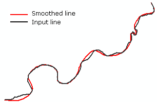
The Smooth tool ![]() is used to smooth the straight edges and angular corners of a feature. The feature geometry is replaced by a series of smoothed line segments.
is used to smooth the straight edges and angular corners of a feature. The feature geometry is replaced by a series of smoothed line segments.
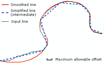
The Smooth tool combines the following steps:
- Simplification with the specified maximum allowable offset (see the description of the Generalize tool, above) to produce a subset (indicated by the blue dashed line in the illustration below) of the original feature vertices (indicated by the black line in the illustration below).
- Bézier interpolation without any parameters, which fits Bézier curves through the subset vertices from the above simplification. The Bessel tangent is used to connect the curves smoothly at vertices (Farin, 1997). The resulting geometry (the red line in the illustration below) can be farther away from the input geometry than the specified maximum allowable offset.
ArcGIS provides other methods of smoothing and simplification. To learn more, see Generalizing line features.
References:
Douglas, D.H. and T.K. Peucker. "Algorithms for the reduction of the number of points required to represent a digitized line or its caricature." The Canadian Cartographer 10(2), pp. 112-122, 1973.
Farin, G. Curves and Surfaces for CAGD: A Practical Guide. 4th Edition. Academic Press, 1997.
How to simplify and smooth features
Simplifying a feature
- Click the Edit tool
 .
.
- Select the feature you want to simplify.
- Click the Generalize tool
 .
.
- Type the maximum allowable offset.
- Click OK.
The maximum allowable offset is the maximum distance in map units that any part of the output geometry can be from the input geometry. You cannot specify the offset in different units by specifying a distance units abbreviation with the value.
Smoothing a feature
- Click the Edit tool .
- Select the feature that you want to smooth.
- Click the Smooth tool
 .
.
- Type the maximum allowable offset.
- Click OK.
The maximum allowable offset is used to derive an intermediate, simplified line from the input line. From this intermediate line, a final smoothed line is then produced (see the figure above). The offset is in map units. You cannot specify the offset in different units by specifying a distance units abbreviation with the value.