Show Navigation
|
Hide Navigation
You are here:
Linear referencing > Getting started with linear referencing
Linear referencing > Getting started with linear referencing
An overview of linear referencing |
|
|
Release 9.2
Last modified September 25, 2007 |


Print all topics in : "Getting started with linear referencing" |
Many organizations collect data about linear features as a point location along the line as an alternative to expressing the location using an xy coordinate.
What is linear referencing?
Linear referencing is the method of storing geographic locations by using relative positions along a measured linear feature. Distance measures are used to locate events along the line:
Measurements along features are used to locate point events and line events using a number of conventions. Here are some common examples.
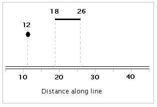
A point can be located along the line in the graph below:
- At measure 12 along the line
- 4 units east of measure marker 10 along the line
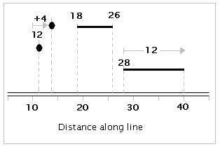
Line features can be referenced in a few ways. In this example above:
- The line starts at measurement 18 and ends at 26
- The line starts at measurement 28 and continues for 12 units
Why use linear referencing?
Linear referencing is used for many reasons. Two primary reasons include:
- Many locations are recorded as events along linear features -- for example, locations of traffic accidents are recorded using a convention such as 27 meters east of the reference mile marker 35 along State Highway 287. Many sensors record conditions along linear features using measures of distance or time along the lines -- along pipelines, along roads, along streams, etc.
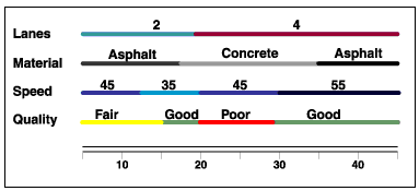
- Linear referencing is also used to associate multiple sets of attributes to portions of linear features without requiring that underlying lines be segmented (split) each time that attribute values change. For example, most road centerline feature classes are segmented where three or more road segments intersect and where the road names change.
Users often want to record many additional attributes about the roads. Without the use of linear referencing, this could require that roads be split into many tiny segments at each location where attribute values change. As an alternative, these situations can be handled as linear referencing events along the roads as in the figure below:
What is dynamic segmentation?
Dynamic segmentation is the process of computing the map locations of events stored and managed in an event table using a linear referencing measurement system and displaying them on a map. The term "dynamic segmentation" is derived from the concept that line features need not be split (i.e.; "segmented") each time an attribute value changes -- you can "dynamically" locate the segment.
Using dynamic segmentation, multiple sets of attributes can be associated with any portion of an existing linear feature independently of where it begins or ends. These attributes can be displayed, queried, edited, and analyzed without affecting the underlying linear feature's geometry.