Show Navigation
|
Hide Navigation
You are here:
Map projections and coordinate systems > Getting started with map projections
Map projections and coordinate systems > Getting started with map projections
An overview of map projections |
|
|
Release 9.2
Last modified November 9, 2006 |


Print all topics in : "Getting started with map projections" |
Related Topics
Within ArcGIS, every dataset has a coordinate system, which is used to integrate it with other geographic data layers within a common coordinate framework such as a map. Coordinate systems enable you to integrate datasets within maps as well as to perform various integrated analytical operations such as overlaying data layers from disparate sources and coordinate systems.
What is a coordinate system?
Coordinate systems enable geographic datasets to use common locations for integration. A coordinate system is a reference system used to represent the locations of geographic features, imagery, and observations such as GPS locations within a common geographic framework.
Each coordinate system is defined by:
- Its measurement framework which is either geographic (in which spherical coordinates are measured from the earth's center) or planimetric (in which the earth's coordinates are projected onto a two-dimensional planar surface).
- Unit of measurement (typically feet or meters for projected coordinate systems or decimal degrees for latitude-longitude).
- The definition of the map projection for projected coordinate systems.
- Other measurement system properties such as a spheroid of reference, a datum, and projection parameters like one or more standard parallels, a central meridian, and possible shifts in the x- and y-directions.
Types of coordinate systems
There are two common types of coordinate systems used in GIS:
- A global or spherical coordinate system such as latitude-longitude. These are often referred to as geographic coordinate systems.
- A projected coordinate system based on a map projection such as transverse Mercator, Albers equal area, or Robinson, all of which (along with numerous other map projection models) provide various mechanisms to project maps of the earth's spherical surface onto a two-dimensional Cartesian coordinate plane. Projected coordinate systems are sometimes referred to as map projections.
For a conceptual overview, see Georeferencing and coordinate systems.
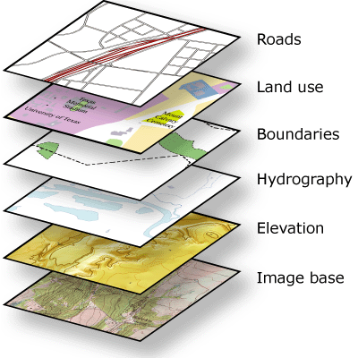
Coordinate systems (either geographic or projected) provide a framework for defining real-world locations. In ArcGIS, the coordinate system is used as the method to automatically integrate the geographic locations from different datasets into a common coordinate framework for display and analysis.
ArcGIS automatically integrates datasets whose coordinate systems are known
All geographic datasets used in ArcGIS are assumed to have a well-defined coordinate system that enables them to be located in relation to the earth's surface.
If your datasets have a well-defined coordinate system, then ArcGIS can automatically integrate your datasets with others by projecting your data on the fly into the appropriate framework—for mapping, 3D visualization, analysis, and so forth.
If your datasets do not have a spatial reference, they cannot be easily integrated. You need to define one before you can use your data effectively in ArcGIS.
What is a spatial reference in ArcGIS?
A spatial reference in ArcGIS is a series of parameters that define the coordinate system and other spatial properties for each dataset in the geodatabase. It is typical that all datasets for the same area (and in the same geodatabase) use a common spatial reference definition.
An ArcGIS spatial reference includes settings for:
- The coordinate system
- The coordinate precision with which coordinates are stored (often referred to as the "coordinate resolution")
- Processing tolerances (such as the cluster tolerance)
- The spatial or map extent covered by the dataset (often referred to as the "spatial domain")
Learning more about coordinate systems
Here is a series of links to help you learn more about applying map projections and coordinate systems in your work.
| Concept | Where to go for more information |
| To understand geographic coordinate systems and latitude-longitude | See About geographic coordinate systems |
| To understand projected coordinate systems | See About projected coordinate systems |
| To learn which map projections are supported | See List of supported map projections |
| To learn about datums | See Datums |
| To learn about spheroids and spheres | See Spheroids and spheres |
| To choose a map projection | See Choosing a map projection
or About coordinate systems and map projections |
| To learn about the geodatabase spatial reference.
|
See the Geodatabase Spatial Reference. |
Common coordinate system and map projection tasks in ArcGIS
Here is a series of links to guidance on how to perform a number of common coordinate system tasks in ArcGIS.
| Common task | Where to go for more information |
| To define the spatial reference for a new dataset in the geodatabase | See An overview of spatial references in the geodatabase |
| To record the coordinate system of an existing dataset | See the "Define Projection" tool in An overview of the Projections and Transformations toolset |
| To define the coordinate system for external raster and image files | See Defining a raster's coordinate system |
| To project feature, rasters, and image data layers | See An overview of the Projections and Transformations toolset |
| To identify an unknown coordinate system | See Identifying an unknown coordinate system |
| Common task | Where to go for more information |
| To learn transformation concepts | See Geographic transformation methods |
| To transform and rubber-sheet data layers | See Performing spatial adjustment |
| To geo-reference unregistered raster data | See Changing the geographic coordinates of a raster dataset: georeferencing |
| To geo-reference unregistered CAD data | See Transforming CAD datasets |
| To perform least-squares adjustment using the Cadastral Editor (which is part of the Survey Analyst Extension) | See About least squares adjustment |
| Common task | Where to go for more information |
| To learn vertical coordinate system concepts | See About vertical coordinate systems |
| To define a vertical coordinate system for a feature class | See Defining feature class properties |