Geoprocessing > Geoprocessing environments
An overview of geoprocessing environments |
|
|
Release 9.2
Last modified October 30, 2007 |


Print all topics in : "Geoprocessing environments" |
Environment settings can be thought of as additional parameters that affect a tool's results. They differ from normal tool parameters in that they don't appear on a tool's dialog (with certain exceptions). Rather, they are values you set once using a separate dialog, and are interrogated and used by tools when they are run.
Changing the environment settings is often a prerequisite to performing geoprocessing tasks. For example, you may already be familiar with the Current and Scratch workspace environment settings, which allow you to set workspaces for inputs and outputs. Another example is the Extent environment setting, which allows your analysis to be limited to a small geographic area, or the Output Coordinate System environment setting, which defines the coordinate system (map projection) for new data.
There are more than 30 different environment settings, arranged in six categories.
-
General settings apply to most tools and contain things such as the current and scratch workspace and the output coordinate system.
Learn more about general settings
-
Cartography settings apply only to tools found in the Cartography toolbox.
Learn more about cartography settings
-
Coverage settings apply only to tools found in the Coverage toolbox.
Learn more about coverage settings
-
Geodatabase settings apply to all tools that output data to a geodatabase.
Learn more about geodatabase settings
-
Raster analysis settings apply to tools that have raster data as input or output.
Learn more about raster analysis settings
-
Raster storage settings apply to tools that output rasters to a geodatabase.
Learn more about raster storage settings
Getting help on a tool's environments
A geoprocessing tool can use any number of environment settings. It is up to the developer of the tool to decide which environment settings will be used by the tool. For system tools developed by ESRI, the tool help will specify which environment settings apply to the tool. To view this information
- Open the tool's dialog from ArcToolbox or ArcCatalog.
- Click the Show Help button to display the tool's help panel.
- In the tool's help panel, click the Help button in the upper left corner to open the tool's help reference page, as shown below.
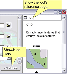
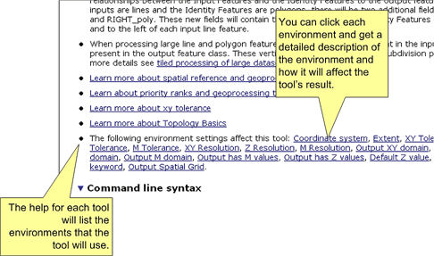
The tool help will have a note that describes which environment settings it will use. This note is typically the last bullet item in the Usage section. (If there is no section on environments in a tool's help, then no environments apply, except for current and scratch workspace.) Each environment setting is a link to the reference help page for the environment. The illustration below shows the help page for the Identity tool.
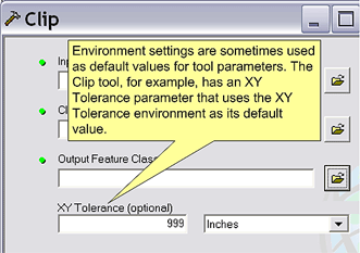
Environments in tool parameters
Some tools have parameters that take their default value from the environment. For example, the Clip tool has an optional XY Tolerance parameter whose default value is retrieved from the XY Tolerance environment setting.
Environment levels and hierarchy
There are four levels of environment settings.
-
Application level settings are the default settings that will be applied to any tool when it is executed.
-
Tool level settings are applied to a single run of a tool and override the application level settings.
-
Model level settings are specified and saved with a mode and override tool level and application level settings.
-
Model process level settings are specified at the model process level, are saved with the model, and override model level settings.
Learn more about environment levels and hierarchy
Specifying environment settings
The way you specify environment settings differs for the four levels.
Learn more about specifying application environment settings
Learn more about specifying tool environment settings
Learn more about specifying model environment settings
Learn more about specifying model process environment settings
Saving environment settings
Application level environments are saved to your geoprocessing settings.
Learn more about geoprocessing settings
Tool level environments are not saved anywhere, as they apply only to a single run of the tool.
Model level and model process level environments are saved with the model.