 Print Topics
About netCDF data |
|
|
Release 9.2
Last modified November 9, 2006 |


Print all topics in : "[PRINTBOOKS_NAME]" |
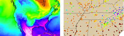
NetCDF (network Common Data Form) is a file format for storing multidimensional scientific data (variables) such as temperature, humidity, pressure, wind speed and direction. Each of these variables can be displayed through a dimension (such as time) in ArcGIS by making a layer or table view from the netCDF file.
Learn more about netCDF
Learn more about how to add netCDF data to ArcGIS
Adding netCDF data in ArcGIS |
|
|
Release 9.2
Last modified November 9, 2006 |
Print all topics in : "[PRINTBOOKS_NAME]" |
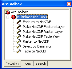
You cannot add a netCDF file using the Add Data ![]() button in ArcGIS applications (ArcMap, ArcScene, or ArcGlobe). You can use the Make NetCDF Raster Layer, Make NetCDF Feature Layer, and Make NetCDF Table View tools from the Multidimension Tools toolbox to create a raster layer, a feature layer, and a table view, respectively, from a netCDF file. You can also drag a netCDF file from Windows Explorer and drop it in an application.
button in ArcGIS applications (ArcMap, ArcScene, or ArcGlobe). You can use the Make NetCDF Raster Layer, Make NetCDF Feature Layer, and Make NetCDF Table View tools from the Multidimension Tools toolbox to create a raster layer, a feature layer, and a table view, respectively, from a netCDF file. You can also drag a netCDF file from Windows Explorer and drop it in an application.
Learn more about creating a raster layer
Learn more about creating a point feature layer
Learn more about creating a table view
Organizations that use netCDF data |
|
|
Release 9.2
Last modified November 9, 2006 |
Print all topics in : "[PRINTBOOKS_NAME]" |
Several organizations and scientific groups in different countries have adopted netCDF as a standard way to represent some forms of scientific data.
Learn more about where netCDF is used
The storage of netCDF data |
|
|
Release 9.2
Last modified November 9, 2006 |
Print all topics in : "[PRINTBOOKS_NAME]" |
The data in a netCDF file is stored in the form of arrays. For example: temperature varying over time at a location is stored as a one dimensional array. Temperature over an area for a given time is stored as a two dimensional array.
Three dimensional (3D) data like temperature over an area varying with time, or four dimensional (4D) data like temperature over an area varying with time and altitude, are stored as a series of two dimensional arrays.
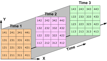
Three dimensional data: Data over an area varying with time.
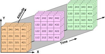
Four dimensional data: Data over an area varying with time and altitude.