Show Navigation
|
Hide Navigation
You are here:
Extensions > Survey Analyst > Cadastral Editor > Cadastral fabric concepts
Extensions > Survey Analyst > Cadastral Editor > Cadastral fabric concepts
Modeling a parcel in the cadastral fabric |
|
|
Release 9.3
Last modified May 13, 2009 |


Print all topics in : "Cadastral fabric concepts" |
Related Topics
A parcel in the cadastral fabric is composed of a series of individual lines that close to form a polygon. Each line has a from and a to point that are also the parcel corner points. Parcel points can have up to one line point and one control point. A parcel is always associated with one plan (record of survey).

Cadastral fabric parcel data model
The survey record (plans)
The cadastral fabric provides a way to enter and organize parcel data based on the manner in which it was originally recorded (record of survey). Parcel data can be manually entered directly from a plan (survey record) or appended from a digital submission of a plan. Parcels are grouped in the cadastral fabric by their associated plan, and the plan properties are maintained in a separate, related table.

The relationship between a parcel and a plan
Learn more about plans.
The parcel data model
A cadastral fabric parcel always has the following geometric elements:
- Points
- Lines
- Polygons
These geometric elements are called parcel features.

Parcel features in the geodatabase
Each parcel polygon in the cadastral fabric is associated with a set of boundary lines or parcel lines.

Relationship between parcels and lines
Parcel lines are defined in the original survey plan or record. Recorded dimensions are stored as coordinate geometry (COGO) attributes on the parcel line in the cadastral fabric.
Learn more about COGO.
COGO dimensions are derived from original raw survey measurements taken in the field. COGO attributes include bearings, distances, and parameters for curved lines. Since COGO dimensions are derived from survey measurements, they can have an associated accuracy. Accuracy can be derived from surveying equipment, date of survey, and so on. Each parcel line in the cadastral fabric has an associated accuracy. Generally, the more recent the recorded survey information (plan), the higher the accuracy of the parcel line and the higher the accuracy of the parcel.
Learn more about accuracy in the cadastral fabric.
Parcel lines in the cadastral fabric also have line categories. The parcel in the diagram below has lines that can be categorized as road frontage lines and lines that can be categorized as connection lines.

Parcel line categories
Each parcel line in the cadastral fabric is a two-point line, from one point to the other. These points are also the corner points of a parcel.

The relationship between parcels and points
A parcel point stores x,y,z coordinates, which are initially generated when the parcel is either migrated or joined to the cadastral fabric. Control points are used in a least-squares adjustment of the cadastral fabric to improve the accuracy of these coordinates. Since parcel point coordinates are a derived quantity, they are held as separate, transient attributes of a parcel point rather than the definition of the point itself.
Learn more about adjusting the cadastral fabric using least squares.

Parcel lines have common end points
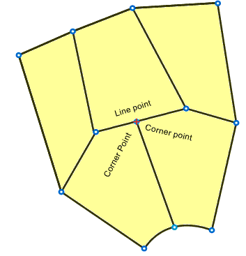
Line points
A parcel point can also be a line point in the cadastral fabric. A line point occurs when the corner point of a parcel lies on the boundary of an adjacent parcel. The adjacent parcel will have a line point lying on its boundary instead of the adjacent parcel corner point. In this way, a parcel boundary is not split or broken by an adjacent parcel corner point in the cadastral fabric. This is important for preserving the recorded information. A parcel boundary should be represented with a single bearing and distance and not with separate bearings and distances if an adjacent parcel corner point is lying on or "splitting" the boundary line.
Parcel shape geometry versus parcel attributes
Each parcel feature (point, line, and polygon) in the cadastral fabric has a shape geometry, which represents the parcel feature on the map. The COGO dimensions on parcel lines and the coordinates on parcel points are held as separate attributes in the parcel feature tables. Parcels in the cadastral fabric thus exist at two separate levels:
- Attributes (COGO attributes on lines and x,y,z attributes on points), which allow parcels to exist independently of their mapped locations and represent the recorded data
- Shape geometry used for mapping parcel features in ArcMap

Cadastral fabric parcels in the geodatabase
Getting parcel data into the cadastral fabric
Parcel data can be entered in the cadastral fabric in the following ways:
- Data migration from an existing source (GIS feature class, COGO coverage)
- Manual entry directly from the plan
- Appending from a digital submission of a plan
Newly created or appended parcels are initially in their own local coordinate systems and are unjoined from the cadastral fabric. Unjoined parcels can be added to the cadastral fabric in a simple, interactive joining process where each parcel corner is matched or joined to its corresponding corner in the cadastral fabric. Parcel joining eliminates problems such as missing spatial reference information in the plan and dealing with parcel data in multiple projections.

Parcel joining
Learn more about joining a parcel to the cadastral fabric.
Learn more about data migration.
Modeling parcel relationships
Just as relationships exist between parcels, lines, and points in the cadastral fabric, relationships exist between parcel features and other cadastral fabric objects such as the relationship between parcels and plans. The following list summarizes the relationships between parcel features themselves and between parcel features and other objects:
- A parcel polygon is related to many lines.
- A parcel line has two endpoints.
- A parcel line is related to only one parcel, resulting in two lines representing common parcel boundaries.
- A parcel point is related to one control point.
- A parcel point is related to one or more lines.
- A line point is related to one or more parcel polygons.
- A line point is related to one parcel line.
- A parcel point is related to one line point.
- A parcel polygon can have many line points.
- A parcel polygon is related to one plan.
- A parcel can have one or more historic parcels (lineage).
- A parcel point can have one or more adjustment vectors.
- A parcel polygon has one accuracy category.
- A parcel line has one accuracy category.