Military Analyst DTED catalogs |
|
|
Release 9.3
Last modified December 4, 2009 |


|
Military Analyst DTED catalogs, like RPF catalogs, are specially formatted geodatabase raster catalogs. Storing DTED data in raster catalogs facilitates the display of large amounts of DTED data, since only the necessary area of interest is processed for analysis.
DTED catalogs can only contain DTED data, but you can store multiple DTED levels in a single catalog. Military Analyst provides recursive data loaders for DTED data, such that DTED rasters are searched for and loaded from all subfolders within a specified input folder.
DTED catalogs can be created in personal, file, or SDE geodatabases. DTED rasters that are loaded into a personal or file geodatabase DTED catalog are referenced; that is, the raster datasets are unmodified and referenced by the catalog from their location on disk. DTED rasters loaded into an SDE DTED catalog are converted to SDE raster datasets and loaded into the underlying RDBMS. Thus, DTED catalogs can act as bulk SDE data loaders for DTED data.
Loading DTED data into catalogs allows access to several tiles, with only one layer displayed in ArcMap. The layer is represented by a wireframe showing the extent footprints of each of the rasters in the catalog. There are many different ways the wireframe can be displayed in relation to the rasters. With DTED catalogs, no immediate merging of data is required for the display or analysis of the surface information—Military Analyst surface analysis functions can be performed on DTED catalogs across DTED tiles.
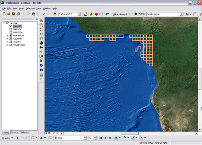
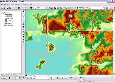
The illustrations below show two different views of a DTED catalog. The top illustration shows the wireframe for the catalog; the wireframe shows the location and extent of each DTED raster contained in the catalog. The bottom illustration shows several DTED tiles being accessed and displayed from a single DTED catalog layer.
Displaying DTED catalogs
Like the RPF layers, a Military Analyst DTED layer’s display is controlled from the Display tab in the Layer Properties dialog box. The Military Analyst DTED layer can display several DTED tiles at one time without the need for mosaicking and can also display multiple DTED levels. However, unlike RPF layers, DTED layers do not support a Best Map Set display property; instead, they always use a locked map set (see DTED raster display options, below, for an explanation of locked map set). Military Analyst DTED catalog layers have color-coded wireframes for quick reference of what products are available and where. To see a complete list of the colors assigned to the products, see MA catalog wireframe symbology.
On the Data Management tab of the Military Analyst Options dialog you can select default settings for new DTED layers including options for wireframe display, raster display and the Uniform Renderer.
Available Products list
All the DTED products available in the catalog are included in the Available Products list. The list is populated with values from the DTED_TYPE field in the catalog’s attribute table. For DTED data loaded into the catalog using the Military Analyst data loaders, the attribute fields, including the Product field, are filled automatically with the appropriate values. To choose the DTED levels from which to display rasters, check the desired products in the Available Products list.
Wireframe display
The options for displaying the wireframe are found in the Wireframe Display section of the Display tab. The wireframe is separate from the raster display. There are three display options: you can display the wireframe for all products in the Available Products list, regardless of what rasters are displayed; you can display the wireframe only for the products that are checked in the Available Products list; or you can choose not to display the wireframe at all.
DTED raster display options
For rasters to be displayed, the Display rasters for selected products check box must be checked.
DTED catalogs do not have the scale-dependent display option that RPF catalogs have. Instead, DTED tiles are always displayed with a lock map set option—the DTED tiles for each DTED product checked in the Available Products list are displayed at all data frame scales.
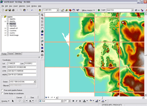
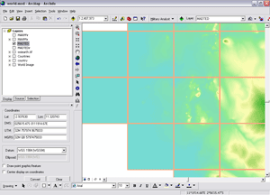
By default, ArcGIS raster catalogs and, thus, Military Analyst DTED catalogs, display each constituent raster with its own renderer. For discrete raster data, such as RPF, this is an enhancement and the preferred display method. For continuous surface raster data, such as DTED, this type of display is visually detrimental. When each DTED tile has its own stretched renderer, it produces a display in which the tile boundaries can easily be determined and don't show the true flow of the data in the area. The tiles, though separate rasters, should display as one surface. For this reason, with the Uniform Renderer check box checked, Military Analyst applies a statistical merge to the layer and creates a uniform renderer to display the data in the DTED catalog. The absolute minimum and maximum pixel values for all the tiles are calculated, and a min-max stretched renderer is applied to the catalog. No physical merging of the DTED rasters occurs. You can select whether or not you want the uniform rendering to apply to the entire catalog or just the visible extent on the Data Management tab of the Military Analyst Options dialog box.
The images below illustrate the effects of using the Uniform Renderer option. The top image shows each DTED tile displayed with its own min-max stretched renderer (the Uniform Renderer option is not being used). The tile boundaries are clearly delineated, and there is no continuity in the displayed surface. The bottom image shows the same DTED catalog, but the Uniform Renderer has been applied, and the tiles appear as a single, continuous surface.
Attributes of DTED catalogs
Military Analyst DTED catalogs have distinct attributes. In the DTED table, the distinct field is the DTED_TYPE field. This field shows the DTED product/level used, and contains values that are used by Military Analyst to assign names to the Available Products list in the product's properties in ArcMap. The minimum number of allowable characters for each record of this text field is 15. NULL values are acceptable.