Show Navigation
|
Hide Navigation
Using simple COGO computations |
|
|
Release 9.3
Last modified May 27, 2009 |


|
Related Topics
About using simple COGO computations
Delta XY
You can compute coordinates for a survey point based on a known difference in coordinates from a given start point.
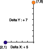
These coordinate differences are termed delta x,y. The direction of the computed coordinates from the start point is defined by the sign of the delta values as shown below:
- Northeast: +X, +Y (as shown above)
- Northwest: -X, +Y
- Southeast: +X, -Y
- Southwest: -X, -Y
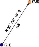
Direction Distance
A familiar coordinate geometry computation is the calculation of a coordinate from an existing coordinate using known distance and direction values.
The direction, based on grid meridian, is either a bearing or azimuth. The survey project's scale correction and angle correction are applied during the computation but do not change the entered values that are stored in the survey dataset.
Deflection-Angle Distance
You can compute a new coordinate by defining a deflection angle offset, based on a reference direction, and a distance from a known point.
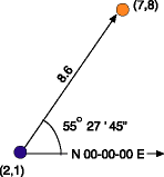
The reference direction is either a bearing or an azimuth, based on grid meridian. The survey project's scale correction is applied during the computation but does not change what is stored for the entered values.
How to use simple COGO computations
Computing a coordinate using delta x,y values
- On the Editor toolbar, click the Editor menu and click Snapping. Click Survey Points in the Snapping Environment window.
- Click the Project drop–down arrow on the Survey Editor toolbar. Click the survey project that should own the delta values, the survey point coordinate, and the computation.
- Click the Computation tool palette drop–down arrow, move the mouse to the first row of buttons on the palette, and click the Delta XY button
 .
.
- Snap to and click the from point on the map.
- If the point is not visible on the map, type its name and press Tab.
- Type the Delta X value and press Tab.
- Type the Delta Y value and press Tab.
- Create a name for the point if you do not want to use the default name. Press Enter.
The name of the point appears in the From Point field.
Computing a coordinate using a direction and a distance from a known point
- On the Editor toolbar, click the Editor menu and click Snapping. Click Survey Points in the Snapping Environment window.
- Click the Project drop–down arrow on the Survey Editor toolbar and click the survey project that should own the direction and distance values, the survey point coordinate, and the computation.
- Click the Computation tool palette drop–down arrow, point the mouse to the first row of buttons on the palette, and click the Direction Distance button
 .
.
- Snap to and click the from point on the map.
- If the point is not visible on the map, type its name and press Tab.
- Type the Direction value and press Tab.
- Type the Distance value and press Tab.
- Type a name for the new point if you do not want to use the default name, then press Enter.
The name of the point appears in the From Point field.
Computing a coordinate using a reference direction, angle offset, and a distance from a known point
- On the Editor toolbar, click the Editor menu and click Snapping. Click Survey Points in the Snapping Environment window.
- Click the Project drop–down arrow on the Survey Editor toolbar, then click the survey project that should own the measurement, point, and computation survey objects.
- Click the Computation tool palette drop–down arrow, point the mouse to the first row of buttons on the palette, and click the Deflection-Angle-Distance button
 .
.
- Snap to and click the from point on the map.
- If the point is not visible on the map, type its name and press Tab.
- Type the Reference Direction and press Tab.
- Type the Angle value and press Tab.
- Type the Distance value and press Tab.
- Type a name for the point if you do not want to use the default name. Press Enter.
The name of the point appears in the From Point field.