Geoprocessing tool reference
Data types for geoprocessing tool parameters |
|
|
Release 9.3
Last modified April 24, 2009 |


Print all topics in : "Geoprocessing tool reference" |
Note:
This topic was updated for 9.3.1.
Geoprocessing is built around the concept of data types. Every tool parameter and every model and command line variable has an associated data type that defines the contents of the variable. Some simple data types are string (any set of alphanumeric characters), boolean (a true/false value), and long (an integer value between -2,147,483,648 and 2,147,483,647). In addition to these simple data types, there are dozens of other data types built specifically for data found in ArcGIS such as Coordinate System and Extent.
Click here
to view a PDF of the Geoprocessing data types. If this link doesn't work, you can open the document (Geoprocessing_data_types.pdf) from the \arcgis\Documentation folder in your ArcGIS Desktop installation location.
To view this document, you need a copy of Adobe Reader, which you can download free from http://www.adobe.com/products/acrobat/readstep.html.
Where data types are needed
Casual geoprocessing users don't need to know about data types. But there are three situations where you are asked to provide data types for variables and parameters.
- In ModelBuilder, when you create a stand-alone variable, you need to provide a data type for the variable to be created.
- In Command Line, when you create a variable with the Variable Manager, you need to provide a data type for the variable to be created.
- When adding a script tool, you need to provide the data type for each of the script tool's parameters.
Learn how to create a variable from a parameter in ModelBuilder.
Learn how to create a variable from a parameter in Command Line.
Data types have a user interface control
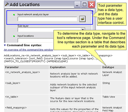
Every geoprocessing data type has an associated user interface control. These user interface controls are used by ArcGIS to construct a tool's dialog box.

Determining a parameter's data type
There are several ways to determine the data type of a parameter.
- In a tool's reference page, both the Command line syntax section and the Scripting syntax section contain a table describing each parameter and its data type.
Learn how to navigate to a tool's reference page. - In ModelBuilder, create a variable from a tool's parameter, right-click the variable, click Properties, then click the Data Type tab. The data type will be listed at the top of the dialog box.
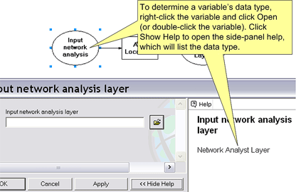
- In ModelBuilder, create a variable from a tool's parameter, open the variable, and click Show Help. The side-panel help will list the data type, as shown below.
- In ModelBuilder, create a model report. The report will list all data types for all parameters.
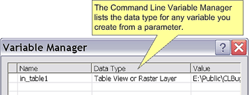
Learn how to make a model report. - In Command Line, create a variable from a parameter. After creating the variable, open the Variable Manager, which will list the data type of the variable, as shown below.

Learn how to create a variable from a parameter in ModelBuilder.

Learn more about creating variables in Command Line.
String syntax
Every data type has a string syntax, which you use for entering a parameter in the command line. This string is also what is passed to scripts.
Most data types have a very simple string syntax such as the path name to a dataset, a number, or a keyword. Other data types have more complex syntax.
The string syntax for a data type can be found in the table of data types or in the reference page for any tool that uses the data type.
Learn how to navigate to a tool's reference page.
If you are unsure of a particular string syntax for a data type, you can try this:
- Locate a tool that uses the data type.
- Execute the tool using its dialog.
- In the progress dialog box or the Command Line window message section, the string syntax for the data type will be shown. If need be, you can copy text from the progress dialog box or Command Line window message section.
Data types and scripting objects
The string syntax of some data types is too complex to use in a script. For example, here is the text string for the Spatial Reference data type that defines an Eckert IV coordinate system:
PROJCS['World_Eckert_IV',
GEOGCS['GCS_WGS_1984',
DATUM['D_WGS_1984',
SPHEROID['WGS_1984',6378137.0,298.257223563]],
PRIMEM['Greenwich',0.0],
UNIT['Degree',0.0174532925199433]],
PROJECTION['Eckert_IV'],
PARAMETER['False_Easting',0.0],
PARAMETER['False_Northing',0.0],
PARAMETER['Central_Meridian',0.0],
UNIT['Meter',1.0]]
For data types with complex strings, ESRI has created scripting objects with methods and properties that allow you to easily create and modify the data type.
Learn more about scripting objects for complex data types.
Data types and ArcObjects
When using a system programming language (such as .NET or Java), you can execute geoprocessing tools using the IGeoProcessor object. When executing tools in this manner, tool parameters (data types) can either be strings, like you would use in the command line, or ArcObjects.
Learn more about using ArcObjects as tool parameters.