Geoprocessing tool reference > Data Management toolbox > Generalization toolset > Tools
Eliminate (Data Management) (ArcInfo only) |
|
|
Release 9.3
Last modified March 8, 2012 |


Print all topics in : "Tools" |
NOTE: This topic was updated for 9.3.1.
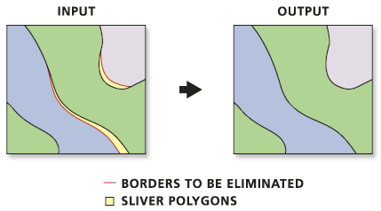
Merges the selected polygons with neighboring polygons with the largest shared border or the largest area
Illustration

Usage tips
-
Features to be eliminated are determined by a selected feature set applied to a polygon layer. The selected set must be determined in a previous step by using Select Layer by Attribute, using Select Layer by Location, or querying a map layer in ArcMap.
-
Only the selected set of polygons from a temporary feature layer will be eliminated.
-
The following environments affect this tool: configKeyword, extent, MDomain, outputCoordinateSystem, outputMFlag, outputZFlag, outputZValue, scratchWorkspace, spatialGrid1, spatialGrid2, spatialGrid3, workspace, XYDomain, and ZDomain.
Command line syntax
An overview of the Command Line window
Eliminate_management <in_features> <out_feature_class> {LENGTH | AREA} {ex_where_clause} {ex_features}
| Parameter | Explanation | Data Type |
| <in_features> |
The layer whose polygons will be merged into neighboring polygons. |
Feature Layer |
| <out_feature_class> |
The feature class to be created. There should be a smaller number of features than in the input layer. |
Feature Class |
| {LENGTH | AREA} |
These options specify which method will be used for eliminating features.
|
Boolean |
| {ex_where_clause} |
An expression used to identify Input Features that should not be modified. |
SQL Expression |
| {ex_features} |
An input polyline or polygon feature class or layer that defines polygon boundaries, or portions thereof, that should not be modified This does not mean the polygon cannot be altered, but it will ensure that the portion of an input polygon boundary that overlaps with features defined by this parameter are not modified. |
Feature Layer |
Command line example
eliminate forest final_forest AREA
Scripting syntax
About getting started with writing geoprocessing scripts
Eliminate_management (in_features, out_feature_class, selection, ex_where_clause, ex_features)
| Parameter | Explanation | Data Type |
| in_features (Required) |
The layer whose polygons will be merged into neighboring polygons. |
Feature Layer |
| out_feature_class (Required) |
The feature class to be created. There should be a smaller number of features than in the input layer. |
Feature Class |
| selection (Optional) |
These options specify which method will be used for eliminating features.
|
Boolean |
| ex_where_clause (Optional) |
An expression used to identify Input Features that should not be modified. |
SQL Expression |
| ex_features (Optional) |
An input polyline or polygon feature class or layer that defines polygon boundaries, or portions thereof, that should not be modified This does not mean the polygon cannot be altered, but it will ensure that the portion of an input polygon boundary that overlaps with features defined by this parameter are not modified. |
Feature Layer |
Data types for geoprocessing tool parameters
Script example
# EliminateSlivers.py
# Description: Eliminate all sliver polygons with area less than 10 square meters.
# Author: ESRI

# Create the Geoprocessor object
import arcgisscripting, sys, string, os
gp = arcgisscripting.create()

myWorkspace = "c:/data/region.mdb"
myFeatures = "forest_area"

try:
    # Set the workspace (to avoid having to type in the full path to the data every time)
    gp.Workspace = MyWorkspace

    # Process: Make feature layer
    gp.MakeFeatureLayer_management(myFeatures, "eliminateLYR", "", "", "GRID_CODE GRID_CODE VISIBLE;geocompID geocompID VISIBLE;Shape_Length Shape_Length VISIBLE;Shape_Area Shape_Area VISIBLE")

    # Process: Select features from layer to be eliminated
    gp.SelectLayerByAttribute_management("eliminateLYR", "NEW_SELECTION", "[Shape_Area] < 10")

    # Process: Eliminate selected features into neighboring polygons with the largest shared border

    gp.Eliminate_management("eliminateLYR", myFeatures + "_out", "LENGTH")

except:
    # If an error occurred while running a tool, print the messages
    print gp.GetMessages()