Extensions > Military Overlay Editor
About MOLE |
|
|
Release 9.3
Last modified December 4, 2009 |


Print all topics in : "Military Overlay Editor" |
- Installation and setup
- Quick reference
- Adding the MOLE toolbar
- Overview of MOLE data
- Accessing the Installing and Getting Started with Defense Solutions guide
- Overview of using MOLE with 2D maps
- Using MOLE with 3D maps
- Overview of using MOLE in terrain analysis
- Creating a MOLE temporal layer in ArcGIS Tracking Analyst
- Overview of using MOLE with ArcIMS
- Using MOLE with ArcSDE
- Overview of advanced topics
- Frequently asked questions
- MOLE documentation and additional ways to get help
Welcome to Military Overlay Editor (MOLE) 9.3.1 SP1. The topics in the MOLE help system also apply to 9.3 unless stated otherwise.
Developed by ESRI for ArcGIS, MOLE is a software application that integrates military symbology specifications into the ArcGIS framework.
With MOLE, you can use ArcGIS software applications to create, update, and distribute military maps that adhere strictly to one or both of the military symbology specifications MOLE supports, MIL-STD-2525B Change 2 and APP-6A.
For example, you can plot the locations of all of your ground troops in a given region on a military operations planning map, then add the nearby locations of potential threats. Examples of threats you can symbolize are suspected enemy force locations, reported mine fields, and hazardous materials.
After you create a map with this information, you can print it for use in briefing or planning meetings, or you can distribute it electronically.
By using symbols in your maps that adhere to the MIL-STD-2525B Change 2 or APP-6A specifications, you guarantee that the symbols can be quickly interpreted by anyone who is familiar with those specifications. In addition, you guarantee that the symbol information you are using can be transferred between systems that are compliant with the specifications.
MOLE is customizable; it comes with an application programming interface (API) you can use to build your own MOLE applications or create custom MOLE functionality in existing applications.
You can use MOLE with shapefiles, single-user geodatabases, or multiuser geodatabases.
MOLE is compatible with ESRI products, including ArcMap, ArcGlobe, ArcCatalog, Military Analyst, ArcIMS, ArcSDE, ArcGIS Tracking Analyst, ArcGIS Server, and ArcGIS Engine. For information on using MOLE with Military Analyst, see Overview of using MOLE in terrain analysis.
This section of the help contains information about the following topics:
-
What you get with MOLE
-
The military specifications supported by MOLE
-
Force elements and tactical graphics
-
An introduction to MOLE data
-
The characteristics of the Symbol ID code
What you get with MOLE
The MOLE software application comes with the following items, which are described in detail in Installing and Getting Started with Defense Solutions:
- A software developer kit (SDK)
- Sample data
-
Three MOLE geoprocessing tools
-
A comprehensive documentation set
-
Online support resources
- Technical support. See http://support.esri.com for more information.
The military specifications supported by MOLE
Ever since it was first released, MOLE has supported the most recent MIL-STD-2525 version at time of release. At 9.3, MOLE supports MIL-STD-2525B Change 2 and APP-6A.
By using symbols in your maps that adhere to the MIL-STD-2525B Change 2 or APP-6A specifications, you guarantee that the symbols can be quickly interpreted by anyone who is familiar with those specifications. In addition, you guarantee that the symbol information you are using can be transferred between systems that are compliant with the specifications.
MOLE also allows you to use symbols that depart from the military specifications if you choose to.
This topic is divided into sections:
About specification documents
A specification document is typically a document that provides detailed information on how something should work. It is usually a living document; it gets revised year to year as needs and systems change.
Many specification documents today are published by collaborative cross-industry groups who want to simplify—through standardization—the transfer and use of information across different types of software applications, computers, and enterprise systems.
The military specifications MOLE supports, MIL-STD-2525B Change 2 and APP-6A, are two such specifications. They give detailed descriptions about how military symbols should look, behave, and be used in battlefield maps and briefing maps. By supporting these specifications, MOLE enables ESRI products, developer frameworks, and their maps to use symbols that adhere to the specifications and to transmit those symbols from system to system.
A direct benefit of military symbol standardization is that it speeds up map interpretation for people who are familiar with a specification—it helps the person reading the map to quickly see where force units are relative to surrounding terrain, obstacles, threats, and so on. The appearance of a symbol also helps the person reading the map to quickly learn a lot about an individual military element. For example, by looking at a force element symbol on a MOLE map, you can quickly tell how big the unit is, if it has mobility, if it is friendly or hostile, and so on.
MIL-STD-2525B Change 2
DOD Military Standard 2525B Change 2, or MIL-STD-2525B Change 2, is a specification document that describes how military symbols should behave and display on maps. The "Change 2" part of the document's title refers to the March 2007 revision of the specification.
Version 9.2 of MOLE supported MIL-STD-2525B Change 1, which preceded Change 2. MIL-STD-2525B Change 1 was published in July 2005. Pre-9.2 versions of MOLE supported MIL-STD-2525B, which preceded MIL-STD-2525B Change 1. MIL-STD-2525B was published in January 1999.
NATO APP-6A
The North Atlantic Treaty Organization (NATO) APP-6A specification is based on MIL-STD-2525A, the predecessor of MIL-STD-2525B. The latest version of APP-6A available at time of 9.3 development was the version released in October 1998. APP-6A is also known as NATO Standardization Agreement (STANAG) APP-6A.
Force elements and tactical graphics
Nearly every MOLE function centers on the rendering of force elements and tactical graphics.
Force elements and tactical graphics are graphics that represent military elements on a map according to the military specification you have chosen.
These graphics are similar to ArcGIS symbols, but MOLE uses the term graphic in place of symbol to reinforce three main distinctions between MOLE graphics and ArcGIS symbols:
- The appearance of MOLE graphics are dependent on a specific field in the layer, the Symbol_ID field. The Symbol_ID field contains Symbol ID code values. A Symbol ID code value determines the appearance of the associated graphic, as explained in the military specification you have chosen.
- In MOLE, each MOLE graphic is a separate entity from its associated ArcGIS feature. Specifically, a MOLE graphic is stored in a separate sublayer from its associated ArcGIS feature. ArcGIS stores symbols and features as one layer, whereas MOLE stores them as two separate layers in a group layer—a graphic layer and a feature layer. (To see the MOLE group layers in ArcGlobe, click the Display tab at the bottom of the table of contents.)
- MOLE force elements can be grouped in leaders and stacks—symbol-like elements that differ slightly from typical ArcGIS symbols. Force element graphics can be displaced from their corresponding ArcGIS point features when you apply leaders and stacks.
- MOLE attribute data behaves as part of the graphic, with a few minor exceptions.

More about force elements
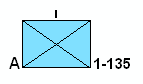
Force elements, also known as tactical symbols, represent military units, equipment, or installations (such as hospitals or radar sites).
The following image is a MOLE symbol that represents a military unit type of force element, in this case, Company A, 1st Battalion of the 135th Infantry.
The following image is a MOLE symbol that represents an installation type of force element, in this case, a hospital:
The following image is a MOLE symbol that represents an equipment type of force element, in this case, a radar sensor:

Force elements are always ArcGIS point features; they are stored in point feature classes.
Force elements are sometimes referred to by a hierarchy code (1.x). Battle dimensions for force elements include space, air, ground, sea surface, sea subsurface, special operations forces, and others.
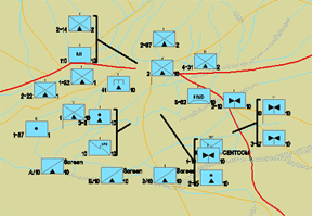
The image below illustrates a friendly set (top) and a hostile set (bottom) of force elements. The top set is in blue, the default color for friendly forces. The bottom set is in red, the default color for hostile forces.

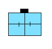
You can apply leadering rules to force elements to group them onto lines known as leader lines. The image below shows four leaders.
More about tactical graphics
Tactical graphics represent command/control and mission planning features, such as movement, obstacles, areas of operation, and so on.
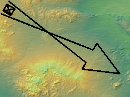
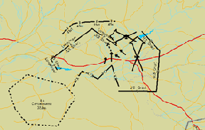
The image below illustrates an airborne axis of advance, a three-point polyline, which is a line tactical graphic.
Tactical graphics are associated with ArcGIS point features, ArcGIS line features, or ArcGIS area features; they are stored in point feature classes, line feature classes, or area feature classes. They are sometimes referred to by a hierarchy code (2.x). Areas are also known as polygons.
MOLE further subdivides tactical graphics into six groups according to military specification categories: tasks, C2 & general maneuver, mobility/survivability, fire support, combat support, and other. Each of these can also have different feature types: points, lines, or areas.
The illustrations below show tactical graphic symbols.

Adding tactical graphics in ArcMap is similar to adding force elements but a bit more complex. Because tactical graphics take on such a wide variety of forms, when you draw the graphics, there are specific geometric properties they must conform to for MOLE to display them properly. Symbology rendering in MOLE provides more detail about the way tactical graphics must be drawn to be rendered by MOLE. For a walk-through of creating a specific tactical graphic, a three-line air corridor, see Creating three-line air corridors.
You can use one of the following methods to add tactical graphics to a map:
- Use the Sketch tool to add the feature, then use the MOLE Symbol Editor to add military symbolization to the feature (to specify what the graphic part of the ArcGIS feature will look like).
- Use the Add MOLE Graphic dialog box, which adds some military symbolization but may require some manual reshaping after the graphic is added to the map.
You can improve performance by disabling the default all-in-one tactical graphic renderer, which renders all tactical graphic types, then enabling only the tactical graphic renderers you need.
MOLE data: an introduction
A key to becoming proficient in MOLE is understanding the data it uses.
MOLE requires that your data be in an ArcGIS native format, such as geodatabase feature classes or shapefiles.
In addition, MOLE requires that a certain set of fields exist in your data because of its close tie to the MIL-STD-2525B Change 2 and APP-6A specifications. The number of fields required depends on how much military symbology data you want to store. At a bare minimum, however, MOLE requires a Symbol_ID field.
Differences between MOLE and ArcGIS data are described below. If you are unfamiliar with how ArcGIS handles data, you may want to first review Overview of MOLE data.
What makes MOLE data different from the ArcGIS data you may be used to?
There are eight main differences:
- MOLE data requires that a specific field, the Symbol_ID field, be present in the data in order for MOLE to read the data.
- The Symbol_ID field contains a 15-character value, where each character or character group within the value has a specific meaning attached. That is, each character or character group has its own set of valid values.
- All MOLE data is related to one of two types of military symbols: force elements or tactical graphics.
- MOLE data displays in the ArcMap or ArcGlobe (Display tab) table of contents as MOLE group layers. Tell me more about MOLE group layers.
- In order to display MOLE data in the map display properly—that is, display it so that it shows the military symbology from the specifications—you must add it to the map using the Add MOLE Data button
 .
.
- By default, the attribute data in a MOLE dataset is used by MOLE only to display labels around a graphic (with a few minor exceptions explained in Attribute data field descriptions). In ArcGIS, however, you may or may not choose to use attribute data for labels.
- In all but a few cases, MOLE attribute data behaves as part of the MOLE graphic. For example, the label displays when the MOLE graphic displays (assuming its visibility is turned on), moves with the MOLE graphic when it moves, and so on.
- MOLE symbology includes leaders and stacks—symbol-like elements that differ slightly from typical ArcGIS symbols. Leaders and stacks represent groups of force elements. Leaders and stacks usually displace a force element graphic from its associated ArcGIS point feature. For more information, see Leadering or Stacking.
NOTE:
- MOLE supports many file formats and datasets, provided they contain at least the minimum fields MOLE requires. Supported formats include feature classes, feature datasets, shapefiles, and single-user and multiuser geodatabases (.mdb, .gdb, and ArcSDE geodatabases included).
- If you are new to ArcGIS, it is helpful to keep in mind that most ESRI products, such as ArcMap and ArcGlobe, treat the map as a different entity than the data. The map display area of the products is a visualization of the data you added to your map. You save this visualization separately from your data. For example, in ArcMap, when you select File > Save, you are saving the visualization—an .mxd file. When you save edits from an edit session, you are saving the data; you are saving to the data source format (feature class, geodatabase, shapefile, and so on).
- MOLE attributes are often called "modifiers" in military specifications.
- Feature types are also known as geometry types or feature geometry.
Think of the .mxd file is as a collection of pointers to data sources and a collection of settings that tell things like which layers (or feature classes) you want to display from those data sources, how you want the layers to display when the map is zoomed in or out, and so on.
1If your MOLE data is stored in non-MOLE feature classes or non-MOLE geodatabases—that is, stored in typical ArcGIS feature classes (simple feature classes) or geodatabases—the MOLE Symbol Editor will not be available to you, but you can manually edit the Symbol ID code and attribute data using the Attributes tool on the ArcMap Editor toolbar.
Symbol ID code
Central to the military specifications MOLE supports—and, therefore, to MOLE—is the Symbol ID code, a 15-character identifier. The code provides the information necessary to display or transmit a military symbol between MIL-STD-2525B Change 2-compliant systems or between APP-6A-compliant systems. The characters that make up the code provide critical information about the military element the code represents: how big the unit is, if it has mobility, if it is hostile, and so on. MOLE takes the information provided in the code and any additional information you provide in attributes and renders the military element as a symbol in ArcGIS.
The presence of this code in a field named Symbol_ID in a dataset allows you to open and use the dataset in MOLE.
How MOLE renders the symbol based on the Symbol ID code
Each character or group of characters in the Symbol ID code gives information about—gives a characteristic of—the military element. For example, the second character in the code tells whether the military element is friendly or hostile; it gives information about the affiliation characteristic.

Symbol ID code
Each of these characteristics has a corresponding visual component that can be drawn or rendered on a map. For example, if the second character is F, the military element is friendly. MIL-STD-2525B Change 2 and APP-6A say friendly should be represented by a blue fill. 1 When several of these components are rendered by MOLE for one military element, they make a complete symbol.
To illustrate, the following image provides a symbol with its visual components—its graphic components—described.

Graphic component example
If you see the above symbol on a map and you are familiar with MIL-STD-2525B Change 2 or APP-6A, you know that the symbol represents a present, friendly, subsurface force element.
The valid values you can use in the code for these characteristics (for example, F is a valid value for the affiliation characteristic) are given in MIL-STD-2525B Change 2 and APP-6A but are also excerpted from MIL-STD-2525B Change 2 in the following tables.
Valid values for force elements
| Coding scheme | Affiliation | Battle dimension | Status |
| S: war fighting
G: tactical graphics W: meteorological and oceanographic (METOC) I: intelligence M: mapping (for future use) O: military operations other than war |
P: pending
U: unknown A: assumed friend F: friend N: neutral S: suspect H: hostile J: joker K: faker O: none specified |
P: space
A: air G: ground S: sea surface U: sea subsurface F: SOF X: other (no frame) |
A: anticipated/planned
P: present |
|
|
|
|
|
| Function ID | Echelon/size | Country code |
Order of battle
|
| Describes the specific function of a symbol. See MIL-STD-2525B Change 2 for values. | Describes echelon, mobility, equipment, or installation characteristics of a symbol. See MIL-STD-2525B Change 2 for specific values. | See FIPS Pub. series 10. | A: air
E: electronic C: civilian G: ground N: maritime S: strategic force related |
Valid values for tactical graphics
| Coding scheme | Affiliation | Category | Status |
| S: C2 symbology: units, equipment, and installations
G: C2 symbology: military operations W: Meteorological and oceanographic (METOC) I: signals intelligence M: mapping (for future use) O: military operations other than war |
P: pending
U: unknown A: assumed friend F: friend N: neutral S: suspect H: hostile J: joker K: faker O: none specified |
T: tasks
G: C2 and general maneuver M: mobility/survivability F: fire support S: combat service support O: other |
A: anticipated/planned
P: present |
|
|
|
|
|
| Function ID | Echelon/size | Country code | Order of battle |
| See MIL-STD-2525B Change 2 for values. | See MIL-STD-2525B Change 2 for values. | See FIPS Pub series 10. | X: control markings |
Use of asterisks and hyphens in Symbol ID codes
The military specifications MOLE supports often use one or more asterisks (*) in sample Symbol ID codes to signify that any valid military specification character can be used in that location, for example, S F * P * * * * * * * * * * *. It is important to keep in mind that these are sample codes only: MOLE does not support the use of asterisks in Symbol ID codes 2 ; it does not recognize an asterisk as a valid character. If you want to indicate that a character in the Symbol ID is unknown, use a hyphen (-) instead (as any character except affiliation or status). For example, if you know the coding scheme is S, affiliation is F, and status is P, and you know no other properties, use hyphens for the other characters; in this case the Symbol ID code would be:
S F - P - - - - - - - - - - -
1MIL-STD-2525B Change 2, APP-6A, and MOLE give other ways to indicate affiliation for a symbol besides fill color.
2There is one exception. MOLE uses an asterisk in the 10th character of the fish stakes' Symbol ID code, as explained in Fish stakes (point tactical graphics).