By default, FME either uses a default value or uses the coordinate system referenced in the input dataset. However, you may want to convert data to a different coordinate system.
For formats that know their coordinate system (such as MapInfo and DLG), the Coordinate System field in the Source Dataset dialog will display "Same as source" and FME will read the coordinate system from the source dataset. For most other input sources, the field will display <not set>, which simply means that FME will use default values.
In order for FME to perform a reprojection, you must specify different destination coordinate system parameters.
Create a workspace, and define your source and destination data.
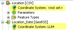
In the source dataset area in the Navigator pane, the Coordinate System parameter will be displayed as <not set>. This means that FME will either use default values, or will read the coordinate system from the source data.

You can explicitly set the source coordinate system (which will override any coordinate system read from the source) but in most cases, you will not need to change the default parameter.
In the destination dataset area of the Navigator pane, double-click the Coordinate System parameter.
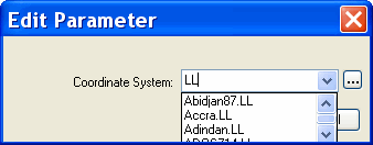
In the dialog that appears, you can either click the Browse button to display the Coordinate System Gallery or enter a prefix or character string that will display a list of matching selections. For example, if you type the string "LL" you will see these matches:

FME will reproject the data to the coordinate system that you enter in this field, and the Navigator pane will display something similar to this:

|
Tip: If you add source or destination datasets to a workspace (by choosing Add Dataset from the Source or Destination Data menus), you can also define coordinate systems in the initial dialog boxes. |
NOTE: Datum shift issues may apply to you. See the topics under Coordinate Systems > Datums.