ArcGIS Server Banner

Data access considerations for geoprocessing tasks

Data access considerations for geoprocessing tasks

Release 9.3 E-mail This TopicPrintable VersionGive Us feedback
Note: This topic was updated for 9.3.1.

Obviously, any resource (data, tools, and documents) used by your task must be accessible by ArcGIS Server when your task executes on the server. This includes datasets referenced directly within your model and datasets referenced by layers in your source map document or result map service, if any.

There are two basic data access configurations: local and distributed. Local data means that all data resides on the server's local disks and is accessed using absolute pathnames (pathnames that begin with a drive letter, such as "E:\"). Distributed data means anything else, where resources are accessed with UNC pathnames (such as \\cogitator\datastore\studyarea.gdb\roads) and database connections and through other servers. You can distribute all resources and data across your local area network as long as the server has access, as illustrated below.

Resource and data configurations

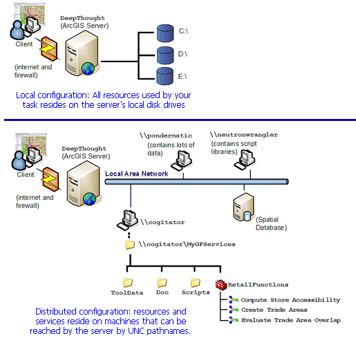
The table below is a guide to topics that discuss data access across a LAN.


Topic Description
An overview of sharing tools and toolboxes This is the introductory topic in the Sharing tools and toolboxes help module.
Sharing and connecting to UNC pathnames This is a topic in the Sharing tools and toolboxes help module and offers specifics on using UNC pathnames to data.
Accessing ArcSDE data in tools This is another topic in the Sharing tools and toolboxes help module with specifics on accessing ArcSDE data.
Preparing resources for publishing as services This is a topic in the ArcGIS Server help that has many details about data access.

Giving ArcGIS Server permission to shared folders

In addition to sharing folders so that services can find resources, you may also have to give ArcGIS Server permission to access shared folders. When ArcGIS Server is configured, the server administrator creates a server object container (SOC) user and account. This account is typically a local account, meaning it is valid only for a particular machine and is not recognized as an account by other machines on the LAN. In most cases, the way to ensure that the SOC account has access is to create the SOC account to the machine that hosts the resource, as follows:

  1. In Windows desktop, right-click My Computer and click Manage.
  2. Expand the Local Users and Groups node.
  3. Right-click Users and choose New User, as shown below.
  4. Adding new user

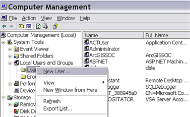
    In the New User dialog box, enter the SOC user name and password supplied by your server administrator.

    NOTE: You must disable the "User must change password at next logon" option. If you do not, then ArcGIS Server will not be able to access your machine and find your documents, data, or tools. You should also enable the "User cannot change password" option and the "Password never expires" option.

  5. Click Create.

A note about address locators

On occasion, you may have a need to use an address locator in your models. (For an example of using an address locator in a model, see the selecting data service example). Address locators have a reference data property as illustrated below. In a distributed data environment, be aware that you may have to use a UNC pathname to this reference data, or use a relative pathname.

Locator properties

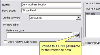
Learn more about creating an address locator

See Also

  • An overview of sharing tools and toolboxes