ArcGIS Server Banner

A short history lesson on simple features

A short history lesson on simple features

Release 9.3 E-mail This TopicPrintable VersionGive Us feedback
Note:This topic was updated for 9.3.1.

During the mid 1990s, interest in simple geometric structures grew. Disk storage and hardware costs in general were coming down while computational speed was growing. At the same time, existing GIS datasets were more readily available, and the work of GIS users was evolving from primarily data compilation activities to include data use, analysis, and data sharing. "Interoperability" was a major buzzword.

Users wanted faster performance for data use (for example, deliver the feature coordinates of these 1,200 polygons as fast as possible). Thousands of geographic information systems were in use, and numerous datasets were readily available.

Around this time, ESRI had developed and published its ESRI shapefile format. Shapefiles used a very simple storage model for feature coordinates. Each shapefile represented a single feature class (of points, lines, or polygons) and used a simple storage model for the feature's coordinates. Shapefiles could be easily created from many geographic information systems. Over time, shapefiles were widely adopted as a de facto standard and are still massively used and deployed today.

A few years later, ArcSDE pioneered a similar simple features storage model in relational database tables. A feature table could hold one feature per row with the geometry in one of its columns along with other feature attribute columns.

A sample feature table of state polygons is shown below. Each row represents a state and the columns hold the attribute properties for each. One of the columns (the shape column) holds the polygon geometry of each state.

Feature class table showing the shape column

This simple features model fit the SQL processing engine very well. Through the use of relational databases, we began to see GIS data scale to unprecedented sizes and numbers of users without degrading performance. We were beginning to leverage RDBMS for GIS data management.

Shapefiles became ubiquitous and, using ArcSDE, this simple features mechanism became the fundamental feature storage model across the GIS industry. (To support interoperability, ESRI was the lead author of the OGC and ISO simple features specification.)

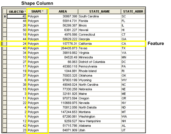
Simple feature storage had clear advantages:

For more information on simple features, see Topology basics.