Feature classes in a geodatabase in PostgreSQL
Feature classes in a geodatabase in PostgreSQL
|
| Release 9.3 |
   |
Note:This topic was updated for 9.3.1.
A feature class is a collection of geographic features, all of the same geometric type (point, line, polygon, multipoint, annotation, dimension, or multipatch). For example, you could store points for all the train depots along a railroad line in one feature class. In another feature class, you could store lines that represent all the railroad tracks.
Below is a description of the way a feature class appears in ArcCatalog, in a PostgreSQL database, and in an XML workspace document. Following that is a description of subtypes, which are used to create subgroups of feature types in a feature class.
Feature classes in ArcCatalog
In the Catalog tree, a feature class stored in a PostgreSQL database looks like this:
 This is a polygon feature class, CensusBlock, which is owned by user perrita and stored in the database, area3.
The icon to the left of the feature class name indicates the type of feature class it is. The icon above represents a polygon feature class. The icons for the other types of feature classes you can create in ArcGIS are as follows:
This is a polygon feature class, CensusBlock, which is owned by user perrita and stored in the database, area3.
The icon to the left of the feature class name indicates the type of feature class it is. The icon above represents a polygon feature class. The icons for the other types of feature classes you can create in ArcGIS are as follows:
 A point or multipoint feature class
 A line feature class
 An annotation feature class
 A dimension feature class
 A multipatch feature class
For a description of the different types of feature classes, see Feature class basics.
A multipatch feature class
For a description of the different types of feature classes, see Feature class basics.
Feature classes in the PostgreSQL DBMS
- Using ST_Geometry storage
By default, feature classes created in geodatabases in a PostgreSQL database management system (DBMS) utilize ST_Geometry storage. That means an ST_Geometry column is added to the business table of the feature class to store the spatial attribute.
ST_Geometry is an abstract, noninstantiable superclass, the subclasses of which are instantiable. For details on ST_Geometry, see The ST_Geometry storage type.
When a feature class is created through ArcGIS using ST_Geometry storage, a business table with an ST_Geometry column is created in the owner's schema. Also, records are added to the sde_layers, sde_table_registry, sde_geometry_columns, sde_column_registry, sde_spatial_references (if a spatial reference was defined), gdb_object_classes, and gdb_featureclasses tables in the SDE user's schema to track information about the feature class.
Once feature classes have been added to the database, you will find there are also several i tables and stored procedures in your database. These stored procedures and i tables are used for generating feature IDs for feature classes. The i tables contain a number in their name. This number corresponds to the registration_id of the feature class in the sde_table_registry table. Editing these tables or stored procedures is not supported and highly discouraged.
To open a diagram of a feature class stored in PostgreSQL using the ST_Geometry type, click the following link. (You need Adobe Reader to open the diagram.)
PostgreSQL ST_Geometry feature class diagram
Dashed lines indicate implicit relationships between columns; solid lines indicate explicitly defined relationships between columns.
The database name field in the gdb_objectclasses, sde_table_registry, sde_columns_registry, and sde_layers tables contains the same value. Similarly, the owners fields in these tables all contain the same values, although the implicit relationships are not drawn on the diagram to avoid clutter.
- Using PostGIS
If you install PostGIS and your database is created using the PostGIS template, you can use its extended well-known text (EWKT) and extended well-known binary (EWKB) spatial types to create feature classes. When you use this, a geometry column is added to the business table to store the feature geometry. In the geodatabase, this geometry storage type is referred to as PG_GEOMETRY.
By default, the GEOMETRY_STORAGE parameter under the DEFAULTS DBTUNE configuration keyword is set to ST_GEOMETRY. If you want to use PG_GEOMETRY storage for most of your feature classes instead, you can alter the GEOMETRY_STORAGE parameter under the DEFAULTS keyword, setting it to PG_GEOMETRY. (Use the sdedbtune command to alter DBTUNE parameter settings.) Or you can specify the PG_GEOMETRY keyword when you create feature classes through ArcGIS or using ArcSDE commands. See DBTUNE configuration keywords for more information on using DBTUNE keywords to control geometry storage.
Feature classes created in ArcGIS using PG_GEOMETRY storage create a business table with a geometry column in the owner's schema. Records are added to all the same tables in the SDE schema as feature classes using ST_GEOMETRY storage. In addition, a record is added to the geometry_columns table in the public schema. For this reason, any user who creates data that uses PG_GEOMETRY storage must have SELECT, INSERT, UPDATE, and DELETE privileges on the public.geometry_columns table.
NOTE: Because there is no PostGIS function to update the table name stored in the public.geometry_columns table, you cannot rename feature classes created using PG_GEOMETRY storage. Renaming the feature class would leave an orphaned row in the public.geometry_storage table.
To see a diagram of a feature class stored in PostgreSQL using the PostGIS geometry type, click the following link:
PostgreSQL PostGIS feature class diagram
For more information on PostGIS geometry storage in the geodatabase, see Using the PostGIS geometry type.
Feature classes stored in an XML workspace document
The following is a small portion of the content of an XML document for a Parcels feature class. The first section is the header; subsequent lines define fields and records in the feature class.
<esri:Workspace xmlns:esri="http://www.esri.com/schemas/ArcGIS/9.3" xmlns:xsi="http://www.w3.org/2001/XMLSchema-instance" xmlns:xs="http://www.w3.org/2001/XMLSchema">
 <WorkspaceDefinition xsi:type="esri:WorkspaceDefinition">
  <WorkspaceType>esriRemoteDatabaseWorkspace</WorkspaceType>
  <Version>sde.DEFAULT</Version>
  <Domains xsi:type="esri:ArrayOfDomain" />
  <DatasetDefinitions xsi:type="esri:ArrayOfDataElement">
   <DataElement xsi:type="esri:DEFeatureClass">
    <CatalogPath>/V=sde.DEFAULT/FC=stegageo.spud.Parcels</CatalogPath>
    <Name>stegageo.spud.Parcels</Name>
    <DatasetType>esriDTFeatureClass</DatasetType>
    <DSID>13</DSID>
    <Versioned>true</Versioned>
    <CanVersion>true</CanVersion>
    <HasOID>true</HasOID>
    <OIDFieldName>objectid</OIDFieldName>
<Fields xsi:type="esri:Fields">
 <FieldArray xsi:type="esri:ArrayOfField">
  <Field xsi:type="esri:Field">
   <Name>objectid</Name>
   <Type>esriFieldTypeOID</Type>
   <IsNullable>false</IsNullable>
   <Length>4</Length>
   <Precision>10</Precision>
   <Scale>0</Scale>
   <Required>true</Required>
   <Editable>false</Editable>
   <DomainFixed>true</DomainFixed>
   <AliasName>OBJECTID</AliasName>
   <ModelName>OBJECTID</ModelName>
  </Field>
  <Field xsi:type="esri:Field">
   <Name>owner</Name>
   <Type>esriFieldTypeString</Type>
   <IsNullable>true</IsNullable>
   <Length>30</Length>
   <Precision>0</Precision>
   <Scale>0</Scale>
  </Field>
  <Field xsi:type="esri:Field">
   <Name>shape</Name>
   <Type>esriFieldTypeGeometry</Type>
   <IsNullable>true</IsNullable>
   <Length>4</Length>
   <Precision>0</Precision>
   <Scale>0</Scale>
   <Required>true</Required>
   <DomainFixed>true</DomainFixed>
   <GeometryDef xsi:type="esri:GeometryDef">
     <AvgNumPoints>0</AvgNumPoints>
     <GeometryType>esriGeometryPolygon</GeometryType>
     <HasM>false</HasM>
     <HasZ>false</HasZ>
     <SpatialReference xsi:type="esri:ProjectedCoordinateSystem">
  <WKT>PROJCS["NAD_1983_StatePlane_North_Carolina_FIPS_3200_Feet",GEOGCS["GCS_North_American_1983",DATUM["D_North_American_1983",SPHEROID["GRS_1980",6378137.0,298.257222101]],PRIMEM["Greenwich",0.0],UNIT["Degree",0.0174532925199433]],PROJECTION["Lambert_Conformal_Conic"],PARAMETER["False_Easting",2000000.002616666],PARAMETER["False_Northing",0.0],PARAMETER["Central_Meridian",-79.0],PARAMETER["Standard_Parallel_1",34.33333333333334],PARAMETER["Standard_Parallel_2",36.16666666666666],PARAMETER["Latitude_Of_Origin",33.75],UNIT["Foot_US",0.3048006096012192],AUTHORITY["EPSG",2264]]</WKT>
         <XOrigin>-121841899.999998</XOrigin>
         <YOrigin>-93658999.9999957</YOrigin>
         <XYScale>728827.12072064</XYScale>
         <ZOrigin>0</ZOrigin>
         <ZScale>1</ZScale>
         <MOrigin>0</MOrigin>
         <MScale>1</MScale>
         <XYTolerance>1.0976539940075E-05</XYTolerance>
         <ZTolerance>2</ZTolerance>
         <MTolerance>2</MTolerance>
         <HighPrecision>true</HighPrecision>
         <WKID>2264</WKID>
       </SpatialReference>
     <GridSize0>-2</GridSize0>
   </GeometryDef>
   <AliasName>SHAPE</AliasName>
   <ModelName>SHAPE</ModelName>
  </Field>
Other field definitions
  <Indexes xsi:type="esri:Indexes">
   <IndexArray xsi:type="esri:ArrayOfIndex">
    <Index xsi:type="esri:Index">
      <Name>r52_sde_rowid_uk</Name>
      <IsUnique>true</IsUnique>
      <IsAscending>true</IsAscending>
      <Fields xsi:type="esri:Fields">
        <FieldArray xsi:type="esri:ArrayOfField">
          <Field xsi:type="esri:Field">
            <Name>objectid</Name>
            <Type>esriFieldTypeOID</Type>
            <IsNullable>false</IsNullable>
            <Length>4</Length>
            <Precision>10</Precision>
            <Scale>0</Scale>
            <Required>true</Required>
            <Editable>false</Editable>
            <DomainFixed>true</DomainFixed>
            <AliasName>OBJECTID</AliasName>
            <ModelName>OBJECTID</ModelName>
          </Field>
        </FieldArray>
      </Fields>
    </Index>
    <Index xsi:type="esri:Index">
      <Name>shape_INDEX</Name>
      <IsUnique>true</IsUnique>
      <IsAscending>true</IsAscending>
      <Fields xsi:type="esri:Fields">
        <FieldArray xsi:type="esri:ArrayOfField">
          <Field xsi:type="esri:Field">
            <Name>shape</Name>
            <Type>esriFieldTypeGeometry</Type>
            <IsNullable>true</IsNullable>
            <Length>4</Length>
            <Precision>0</Precision>
            <Scale>0</Scale>
            <Required>true</Required>
            <DomainFixed>true</DomainFixed>
            <GeometryDef xsi:type="esri:GeometryDef">
              <AvgNumPoints>0</AvgNumPoints>
              <GeometryType>esriGeometryPolygon</GeometryType>
              <HasM>false</HasM>
              <HasZ>false</HasZ>
              <SpatialReference xsi:type="esri:ProjectedCoordinateSystem">
  <WKT>PROJCS["NAD_1983_StatePlane_North_Carolina_FIPS_3200_Feet",GEOGCS["GCS_North_American_1983",DATUM["D_North_American_1983",SPHEROID["GRS_1980",6378137.0,298.257222101]],PRIMEM["Greenwich",0.0],UNIT["Degree",0.0174532925199433]],PROJECTION["Lambert_Conformal_Conic"],PARAMETER["False_Easting",2000000.002616666],PARAMETER["False_Northing",0.0],PARAMETER["Central_Meridian",-79.0],PARAMETER["Standard_Parallel_1",34.33333333333334],PARAMETER["Standard_Parallel_2",36.16666666666666],PARAMETER["Latitude_Of_Origin",33.75],UNIT["Foot_US",0.3048006096012192],AUTHORITY["EPSG",2264]]</WKT>
                <XOrigin>-121841899.999998</XOrigin>
                <YOrigin>-93658999.9999957</YOrigin>
                <XYScale>728827.12072064</XYScale>
                <ZOrigin>0</ZOrigin>
                <ZScale>1</ZScale>
                <MOrigin>0</MOrigin>
                <MScale>1</MScale>
                <XYTolerance>1.0976539940075E-05</XYTolerance>
                <ZTolerance>2</ZTolerance>
                <MTolerance>2</MTolerance>
                <HighPrecision>true</HighPrecision>
                <WKID>2264</WKID>
              </SpatialReference>
            <GridSize0>-2</GridSize0>
           </GeometryDef>
           <AliasName>SHAPE</AliasName>
           <ModelName>SHAPE</ModelName>
          </Field>
         </FieldArray>
       </Fields>
     </Index>
   </IndexArray>
  </Indexes>
  <CLSID>{55555552-876A-54D0-BEC3-02805F7C4268}</CLSID>
  <EXTCLSID />
  <RelationshipClassNames xsi:type="esri:Names" />
  <AliasName>stegageo.spud.Parcels</AliasName>
  <ModelName />
  <HasGlobalID>false</HasGlobalID>
  <GlobalIDFieldName />
  <RasterFieldName />
  <ExtensionProperties xsi:type="esri:PropertySet">
   <PropertyArray xsi:type="esri:ArrayOfPropertySetProperty" />
  </ExtensionProperties>
  <ControllerMemberships xsi:type="esri:ArrayOfControllerMembership" />
  <FeatureType>esriFTSimple</FeatureType>
  <ShapeType>esriGeometryPolygon</ShapeType>
  <ShapeFieldName>shape</ShapeFieldName>
  <HasM>false</HasM>
  <HasZ>false</HasZ>
  <HasSpatialIndex>true</HasSpatialIndex>
  <AreaFieldName>st_area(shape)</AreaFieldName>
  <LengthFieldName>st_length(shape)</LengthFieldName>
  <Extent xsi:type="esri:EnvelopeN">
    <XMin>2307724.86677502</XMin>
    <YMin>717699.787872195</YMin>
    <XMax>2317445.56934058</XMax>
    <YMax>725057.407916173</YMax>
    <SpatialReference xsi:type="esri:ProjectedCoordinateSystem">
  <WKT>PROJCS["NAD_1983_StatePlane_North_Carolina_FIPS_3200_Feet",GEOGCS["GCS_North_American_1983",DATUM["D_North_American_1983",SPHEROID["GRS_1980",6378137.0,298.257222101]],PRIMEM["Greenwich",0.0],UNIT["Degree",0.0174532925199433]],PROJECTION["Lambert_Conformal_Conic"],PARAMETER["False_Easting",2000000.002616666],PARAMETER["False_Northing",0.0],PARAMETER["Central_Meridian",-79.0],PARAMETER["Standard_Parallel_1",34.33333333333334],PARAMETER["Standard_Parallel_2",36.16666666666666],PARAMETER["Latitude_Of_Origin",33.75],UNIT["Foot_US",0.3048006096012192],AUTHORITY["EPSG",2264]]</WKT>
        <XOrigin>-121841899.999998</XOrigin>
        <YOrigin>-93658999.9999957</YOrigin>
        <XYScale>728827.12072064</XYScale>
        <ZOrigin>0</ZOrigin>
        <ZScale>1</ZScale>
        <MOrigin>0</MOrigin>
        <MScale>1</MScale>
        <XYTolerance>1.0976539940075E-05</XYTolerance>
        <ZTolerance>2</ZTolerance>
        <MTolerance>2</MTolerance>
        <HighPrecision>true</HighPrecision>
        <WKID>2264</WKID>
       </SpatialReference>
      </Extent>
    </DataElement>
  <DatasetDefinitions>
<WorkspaceDefinition>
<WorkspaceData xsi:type="esri:WorkspaceData">
 <DatasetData xsi:type="esri:TableData">
  <DatasetName>stegageo.spud.Parcels</DatasetName>
  <DatasetType>esriDTFeatureClass</DatasetType>
  <Data xsi:type="esri:RecordSet">
   <Fields xsi:type="esri:Fields">
    <FieldArray xsi:type="esri:ArrayOfField">
     <Field xsi:type="esri:Field">
      <Name>objectid</Name>
      <Type>esriFieldTypeOID</Type>
      <IsNullable>false</IsNullable>
      <Length>4</Length>
      <Precision>10</Precision>
      <Scale>0</Scale>
      <Required>true</Required>
      <Editable>false</Editable>
      <DomainFixed>true</DomainFixed>
      <AliasName>OBJECTID</AliasName>
      <ModelName>OBJECTID</ModelName>
     </Field>
     <Field xsi:type="esri:Field">
      <Name>mbl</Name>
      <Type>esriFieldTypeString</Type>
      <IsNullable>true</IsNullable>
      <Length>30</Length>
      <Precision>0</Precision>
      <Scale>0</Scale>
     </Field>
     <Field xsi:type="esri:Field">
      <Name>owner</Name>
      <Type>esriFieldTypeString</Type>
      <IsNullable>true</IsNullable>
      <Length>30</Length>
      <Precision>0</Precision>
      <Scale>0</Scale>
     </Field>
All other fields
<Records xsi:type="esri:ArrayOfRecord">
 <Record xsi:type="esri:Record">
  <Values xsi:type="esri:ArrayOfValue">
   <Value xsi:type="xs:int">2</Value>
   <Value xsi:type="xs:string">047_0040010</Value>
   <Value xsi:type="xs:string">BISSETTE PAUL B JR & BETTIE</Value>
   <Value xsi:type="xs:string" />
   <Value xsi:type="xs:string">1000 SALEM ST</Value>
   <Value xsi:type="xs:string">WILSON</Value>
   <Value xsi:type="xs:string">NC</Value>
   <Value xsi:type="xs:int">278930000</Value>
   <Value xsi:type="xs:string">RA12S</Value>
   <Value xsi:type="esri:PolygonB">
      <Bytes>BQAAAEDEX0D4rUFBgNZ65N8YJkHgOhpHPq5BQYCx9P6xGSZBAQAAAAYAAAAAAAAAQJfNNj6uQUEA /vBvpBkmQeA6Gkc+rkFBgNZ65N8YJkFAxF9A+K1BQQAM8X7rGCZBQMRfQPitQUGATe/+8hgmQaAU YGD5rUFBgLH0/rEZJkFAl802Pq5BQQD+8G+kGSZB</Bytes>
   </Value>
   <Value xsi:type="xs:double">13725.2605662117</Value>
   <Value xsi:type="xs:double">475.563707068856</Value>
  </Values>
 </Record>
 <Record xsi:type="esri:Record">
  <Values xsi:type="esri:ArrayOfValue">
   <Value xsi:type="xs:int">7</Value>
   <Value xsi:type="xs:string">012A0010004</Value>
   <Value xsi:type="xs:string">WESTWOOD VILLAGE LIMITED</Value>
   <Value xsi:type="xs:string">PARTNERSHIP</Value>
   <Value xsi:type="xs:string">PO BOX 1329</Value>
   <Value xsi:type="xs:string">WILSON</Value>
   <Value xsi:type="xs:string">NC</Value>
   <Value xsi:type="xs:int">278941329</Value>
   <Value xsi:type="xs:string">B4</Value>
   <Value xsi:type="esri:PolygonB">
      <Bytes>BQAAAGBy7mJzo0FBgB7xfrIXJkFAbWBgXqRBQQAVQTdTGSZBAQAAAAQAAAAAAAAAQG1gYF6kQUGA HvF+shcmQWBy7mJzo0FBAEtKN7IYJkHAqkrSiKNBQQAVQTdTGSZBQG1gYF6kQUGAHvF+shcmQQ==</Bytes>
     </Value>
     <Value xsi:type="xs:double">21657.360535662</Value>
     <Value xsi:type="xs:double">1053.48849470802</Value>
    </Values>
   </Record>
All other records
    </Records>
   </Data>
  </DatasetData>
 </WorkspaceData>
</esri:Workspace>
Subtypes in feature classes
Subtypes are used to differentiate feature types within a feature class based on their default values, attribute domains, connectivity rules, and relationship rules. Subtypes are defined for a feature class, and only one field in the feature class can have subtypes defined for it.
Subtypes in ArcCatalog
Since subtypes are defined on the feature class, you define and view subtypes in ArcCatalog from the Feature Class Properties dialog box. Right-click the feature class, click Properties, then click the Subtypes tab to see the following dialog box:
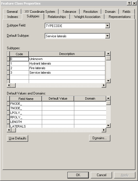
This example shows subtypes applied to the TYPECODE field for a feature class, Laterals. You see the codes used for the subtypes, the descriptions (names) of the subtypes, and the default subtype for the TYPECODE field in the Laterals feature class.
Subtypes in a PostgreSQL DBMS
The following system tables in a PostgreSQL DBMS are used to track information about subtypes applied to a field in a feature class:
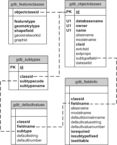
In this example, the Laterals feature class is identified in the gdb_objectclasses system table. Additional information about the feature class is maintained in the gdb_featureclasses and gdb_fieldinfo system tables.
The subtypes for feature classes are tracked in the gdb_subtypes system table, the default values for the subtypes are tracked in the gdb_defaultvalues system table, and the fields to which these apply are tracked in the gdb_fieldinfo system table. The subtypes are associated to the feature class by way of the gdb_objectclasses table. The gdb_defaultvalues table is associated with the gdb_subtypes table by the subtype code, which is stored in the subtypecode field in the gdb_subtypes table and the subtype field in the gdb_defaultvalues table.
The name of the field to which the subtype applies is stored in the subtypefield column of the gdb_objectclasses table. This field is linked to the fieldname column in the gdb_fieldinfo table, which in turn is associated to the fieldname column in the gdb_defaultvalues table.
Subtypes in an XML workspace document
Subtypes appear in XML documents as part of the information for the feature class. They are grouped under a Subtypes tag. For the Laterals example, the subtype information in an XML document is as follows:
- <Subtypes xsi:type="esri:ArrayOfSubtype">
   <Subtype xsi:type="esri:Subtype">
      <SubtypeName>Unknown</SubtypeName>
      <SubtypeCode>0</SubtypeCode>
     <FieldInfos xsi:type="esri:ArrayOfSubtypeFieldInfo">
       <SubtypeFieldInfo xsi:type="esri:SubtypeFieldInfo">
          <FieldName>H_CONFID</FieldName>
          <DefaultValue xsi:type="xs:int">0</DefaultValue>
       </SubtypeFieldInfo>
       <SubtypeFieldInfo xsi:type="esri:SubtypeFieldInfo">
          <FieldName>DIAMETER</FieldName>
          <DomainName>LatDiameter</DomainName>
          <DefaultValue xsi:type="xs:double">8</DefaultValue>
       </SubtypeFieldInfo>
       <SubtypeFieldInfo xsi:type="esri:SubtypeFieldInfo">
          <FieldName>DEPTH_BURI</FieldName>
          <DefaultValue xsi:type="xs:double">0</DefaultValue>
       </SubtypeFieldInfo>
       <SubtypeFieldInfo xsi:type="esri:SubtypeFieldInfo">
          <FieldName>RECORDED_L</FieldName>
          <DefaultValue xsi:type="xs:double">0</DefaultValue>
       </SubtypeFieldInfo>
       <SubtypeFieldInfo xsi:type="esri:SubtypeFieldInfo">
          <FieldName>WNM_TYPE</FieldName>
          <DefaultValue xsi:type="xs:string">WUNKNOWN</DefaultValue>
       </SubtypeFieldInfo>
       <SubtypeFieldInfo xsi:type="esri:SubtypeFieldInfo">
          <FieldName>PWTYPE</FieldName>
          <DefaultValue xsi:type="xs:string">WUNKNOWN</DefaultValue>
       </SubtypeFieldInfo>
       <SubtypeFieldInfo xsi:type="esri:SubtypeFieldInfo">
          <FieldName>MATERIAL</FieldName>
          <DomainName>Material</DomainName>
          <DefaultValue xsi:type="xs:string">DI</DefaultValue>
       </SubtypeFieldInfo>
       <SubtypeFieldInfo xsi:type="esri:SubtypeFieldInfo">
          <FieldName>TYPECODE</FieldName>
          <DefaultValue xsi:type="xs:int">3</DefaultValue>
       </SubtypeFieldInfo>
       <SubtypeFieldInfo xsi:type="esri:SubtypeFieldInfo">
          <FieldName>ENABLED</FieldName>
          <DomainName>EnabledDomain</DomainName>
          <DefaultValue xsi:type="xs:short">1</DefaultValue>
       </SubtypeFieldInfo>
    </FieldInfos>
  </Subtype>
 <Subtype xsi:type="esri:Subtype">
    <SubtypeName>Hydrant laterals</SubtypeName>
    <SubtypeCode>1</SubtypeCode>
   <FieldInfos xsi:type="esri:ArrayOfSubtypeFieldInfo">
       <SubtypeFieldInfo xsi:type="esri:SubtypeFieldInfo">
          <FieldName>H_CONFID</FieldName>
          <DefaultValue xsi:type="xs:int">0</DefaultValue>
       </SubtypeFieldInfo>
       <SubtypeFieldInfo xsi:type="esri:SubtypeFieldInfo">
          <FieldName>DIAMETER</FieldName>
          <DomainName>LatDiameter</DomainName>
          <DefaultValue xsi:type="xs:double">8</DefaultValue>
       </SubtypeFieldInfo>
       <SubtypeFieldInfo xsi:type="esri:SubtypeFieldInfo">
          <FieldName>DEPTH_BURI</FieldName>
          <DefaultValue xsi:type="xs:double">0</DefaultValue>
       </SubtypeFieldInfo>
       <SubtypeFieldInfo xsi:type="esri:SubtypeFieldInfo">
          <FieldName>RECORDED_L</FieldName>
          <DefaultValue xsi:type="xs:double">0</DefaultValue>
       </SubtypeFieldInfo>
       <SubtypeFieldInfo xsi:type="esri:SubtypeFieldInfo">
          <FieldName>WNM_TYPE</FieldName>
          <DefaultValue xsi:type="xs:string">WHYDLIN</DefaultValue>
       </SubtypeFieldInfo>
       <SubtypeFieldInfo xsi:type="esri:SubtypeFieldInfo">
          <FieldName>PWTYPE</FieldName>
          <DefaultValue xsi:type="xs:string">WHYDLIN</DefaultValue>
       </SubtypeFieldInfo>
       <SubtypeFieldInfo xsi:type="esri:SubtypeFieldInfo">
          <FieldName>MATERIAL</FieldName>
          <DomainName>Material</DomainName>
          <DefaultValue xsi:type="xs:string">DI</DefaultValue>
       </SubtypeFieldInfo>
       <SubtypeFieldInfo xsi:type="esri:SubtypeFieldInfo">
          <FieldName>ENABLED</FieldName>
          <DomainName>EnabledDomain</DomainName>
          <DefaultValue xsi:type="xs:short">1</DefaultValue>
       </SubtypeFieldInfo>
    </FieldInfos>
  </Subtype>
 <Subtype xsi:type="esri:Subtype">
    <SubtypeName>Fire laterals</SubtypeName>
    <SubtypeCode>2</SubtypeCode>
   <FieldInfos xsi:type="esri:ArrayOfSubtypeFieldInfo">
       <SubtypeFieldInfo xsi:type="esri:SubtypeFieldInfo">
          <FieldName>H_CONFID</FieldName>
          <DefaultValue xsi:type="xs:int">0</DefaultValue>
       </SubtypeFieldInfo>
       <SubtypeFieldInfo xsi:type="esri:SubtypeFieldInfo">
          <FieldName>DIAMETER</FieldName>
          <DomainName>LatDiameter</DomainName>
          <DefaultValue xsi:type="xs:double">8</DefaultValue>
       </SubtypeFieldInfo>
       <SubtypeFieldInfo xsi:type="esri:SubtypeFieldInfo">
          <FieldName>DEPTH_BURI</FieldName>
          <DefaultValue xsi:type="xs:double">0</DefaultValue>
       </SubtypeFieldInfo>
       <SubtypeFieldInfo xsi:type="esri:SubtypeFieldInfo">
          <FieldName>RECORDED_L</FieldName>
          <DefaultValue xsi:type="xs:double">0</DefaultValue>
       </SubtypeFieldInfo>
       <SubtypeFieldInfo xsi:type="esri:SubtypeFieldInfo">
          <FieldName>WNM_TYPE</FieldName>
          <DefaultValue xsi:type="xs:string">WFIRELIN</DefaultValue>
       </SubtypeFieldInfo>
       <SubtypeFieldInfo xsi:type="esri:SubtypeFieldInfo">
          <FieldName>PWTYPE</FieldName>
          <DefaultValue xsi:type="xs:string">WFIRELIN</DefaultValue>
       </SubtypeFieldInfo>
       <SubtypeFieldInfo xsi:type="esri:SubtypeFieldInfo">
          <FieldName>MATERIAL</FieldName>
          <DomainName>Material</DomainName>
         <DefaultValue xsi:type="xs:string">DI</DefaultValue>
       </SubtypeFieldInfo>
       <SubtypeFieldInfo xsi:type="esri:SubtypeFieldInfo">
          <FieldName>ENABLED</FieldName>
          <DomainName>EnabledDomain</DomainName>
          <DefaultValue xsi:type="xs:short">1</DefaultValue>
       </SubtypeFieldInfo>
    </FieldInfos>
  </Subtype>
 <Subtype xsi:type="esri:Subtype">
    <SubtypeName>Service laterals</SubtypeName>
    <SubtypeCode>3</SubtypeCode>
   <FieldInfos xsi:type="esri:ArrayOfSubtypeFieldInfo">
       <SubtypeFieldInfo xsi:type="esri:SubtypeFieldInfo">
          <FieldName>H_CONFID</FieldName>
          <DefaultValue xsi:type="xs:int">0</DefaultValue>
       </SubtypeFieldInfo>
       <SubtypeFieldInfo xsi:type="esri:SubtypeFieldInfo">
          <FieldName>DIAMETER</FieldName>
          <DomainName>LatDiameter</DomainName>
          <DefaultValue xsi:type="xs:double">8</DefaultValue>
       </SubtypeFieldInfo>
       <SubtypeFieldInfo xsi:type="esri:SubtypeFieldInfo">
          <FieldName>DEPTH_BURI</FieldName>
          <DefaultValue xsi:type="xs:double">0</DefaultValue>
       </SubtypeFieldInfo>
       <SubtypeFieldInfo xsi:type="esri:SubtypeFieldInfo">
          <FieldName>RECORDED_L</FieldName>
          <DefaultValue xsi:type="xs:double">0</DefaultValue>
       </SubtypeFieldInfo>
       <SubtypeFieldInfo xsi:type="esri:SubtypeFieldInfo">
          <FieldName>WNM_TYPE</FieldName>
          <DefaultValue xsi:type="xs:string">WSERVICE</DefaultValue>
       </SubtypeFieldInfo>
       <SubtypeFieldInfo xsi:type="esri:SubtypeFieldInfo">
          <FieldName>PWTYPE</FieldName>
          <DefaultValue xsi:type="xs:string">WSERVICE</DefaultValue>
      </SubtypeFieldInfo>
      <SubtypeFieldInfo xsi:type="esri:SubtypeFieldInfo">
          <FieldName>MATERIAL</FieldName>
          <DomainName>Material</DomainName>
          <DefaultValue xsi:type="xs:string">DI</DefaultValue>
       </SubtypeFieldInfo>
       <SubtypeFieldInfo xsi:type="esri:SubtypeFieldInfo">
          <FieldName>ENABLED</FieldName>
          <DomainName>EnabledDomain</DomainName>
          <DefaultValue xsi:type="xs:short">1</DefaultValue>
       </SubtypeFieldInfo>
    </FieldInfos>
  </Subtype>
</Subtypes>
