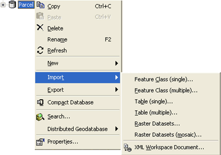
To import datasets using the context-sensitive menu in ArcCatalog, right-click on the geodatabase and click Import. Choose the type of data you would like to import:

- Feature Class (single)—Converts a shapefile, coverage feature class, or geodatabase feature class to a shapefile or geodatabase feature class using the Feature Class To Feature Class tool
- Feature Class (multiple)—Converts one or more feature classes or feature layers to geodatabase feature classes using the Feature Class To Geodatabase tool
- Table (single)—Converts an input table to a dBASE or a personal, file, or ArcSDE geodatabase table using the Table To Table tool
- Table (multiple)—Imports one or more tables into a file, personal, or ArcSDE geodatabase using the Table To Geodatabase tool
- Raster Datasets (single)—Loads multiple raster datasets into a geodatabase or raster catalog
- Raster Datasets (mosaic)—Mosaics multiple input rasters into a single raster dataset (The target raster must be an existing raster dataset, which can be an empty raster dataset or one already containing data.)
- XML Workspace Document—Imports data or schema from an XML document into a geodatabase
To import datasets using ArcToolbox, open the Conversion Toolbox and navigate to the To Geodatabase toolset. This contains the same tools as those accessed from the context-sensitive menu.
Learn more about the To Geodatabase toolset.


