 |
Raster datasets and raster catalogs in a geodatabase stored in Oracle |
|
| Release 9.3 |    |
 A raster catalog in the ArcCatalog tree would appear as follows:
NOTE: Beginning with Oracle 11g, LONG RAW data types are no longer supported. Therefore, ESRI recommends you do not create new raster datasets using LONG RAW storage.

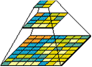
 When you build a pyramid, more pixels are created by progressively downsampling the previous level by a factor of two until the apex. As the application zooms out and the raster cells grow smaller than the resolution threshold, ArcSDE selects a higher level of the pyramid. The purpose of the pyramid is to optimize display performance.
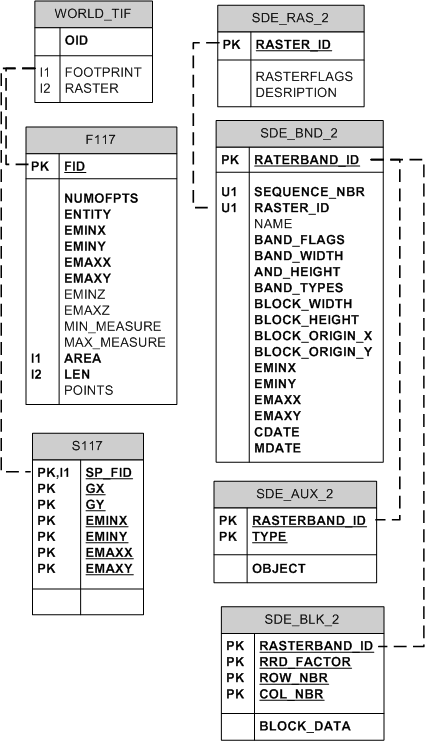
The following are the table definitions for the raster tables:
NOTE: You will only have the raster tables in your geodatabase if you have raster data in the geodatabase.
SDE_AUX_<raster_column_ID>The raster auxiliary table stores the image color map, image statistics, and the optional bit mask, which is used for image overlays and mosaicking.| Field name | Field type | Description |
|---|---|---|
| RASTERBAND_ID | NUMBER(38) | A number that represents a raster band; for example, a raster dataset with two raster bands would have two different values in this field—1 and 2 NOT NULL |
| TYPE | NUMBER(38) | Values include 2 = raster statistics 3 = color map 4 = coordinate transformation 5 = reserved for geodatabase 6 = miscellaneous NOT NULL |
| OBJECT | LONG RAW or BLOB | Contains the actual data, either a color map index, raster statistics, or coordinate transformation NOT NULL |
| Field name | Field type | Description |
|---|---|---|
| RASTERBAND_ID | NUMBER(38) | A number that represents a raster band; for example, a raster dataset with two raster bands would have two different values in this field—1 and 2 NOT NULL |
| RRD_FACTOR | NUMBER(38) | Pyramid level; pyramid levels begin at 0 and can increase from there NOT NULL |
| ROW_NBR | NUMBER(38) | Tile row number position NOT NULL |
| COL_NBR | NUMBER(38) | Column row number position NOT NULL |
| BLOCK_DATA | LONG RAW or BLOB | Pixel data stored in the tile NOT NULL |
| Field name | Field type | Description |
|---|---|---|
| RASTERBAND_ID | NUMBER(38) | A number that represents a raster band; for example, a raster dataset with two raster bands would have two different values in this field—1 and 2 NOT NULL |
| SEQUENCE_NBR | NUMBER(38) | Sequence of the raster band within the raster dataset NOT NULL |
| RASTER_ID | NUMBER(38) | The unique identifier of the raster dataset; corresponds to the value in the raster column of the business table NOT NULL |
| NAME | VARCHAR2(65) | The optional raster band name |
| BAND_FLAGS | NUMBER(38) | A bit mask containing properties about the band NOT NULL |
| BAND_WIDTH | NUMBER(38) | The pixel width of the band NOT NULL |
| BAND_HEIGHT | NUMBER(38) | The pixel height of the band NOT NULL |
| BAND_TYPES | NUMBER(38) | A bit mask containing properties about the band NOT NULL |
| BLOCK_WIDTH | NUMBER(38) | The pixel width of a block NOT NULL |
| BLOCK_HEIGHT | NUMBER(38) | The pixel height of a block NOT NULL |
| BLOCK_ORIGIN_X | NUMBER(64) | The x-coordinate of the raster origin NOT NULL |
| BLOCK_ORIGIN_Y | NUMBER(64) | The y-coordinate of the raster origin NOT NULL |
| EMINX | NUMBER(64) | The minimum x-value of a raster band; with eminy, emaxx, and emaxy, defines the envelope of a raster band NOT NULL |
| EMINY | NUMBER(64) | The minimum y-value of a raster band; with eminx, emaxx, and emaxy, defines the envelope of a raster band NOT NULL |
| EMAXX | NUMBER(64) | The maximum x-value of a raster band; with eminx, eminy, and emaxy, defines the envelope of a raster band NOT NULL |
| EMAXY | NUMBER(64) | The maximum y-value in a raster band; with eminx, eminy, and emaxx, defines the envelope of a raster band NOT NULL |
| CDATE | NUMBER(38) | The creation date of the raster band NOT NULL |
| MDATE | NUMBER(38) | The last modification date of the raster band NOT NULL |
| Field name | Field type | Description |
|---|---|---|
| RASTER_ID | NUMBER(38) | The unique identifier of the raster dataset; corresponds to the value in the raster column of the business table NOT NULL |
| RASTER_FLAGS | NUMBER(38) | Reserved for future use |
| DESCRIPTION | VARCHAR2(65) | The description of the raster dataset |
| Name | Example component value |
|---|---|
| RASTER | SDO_GEORASTER |
| RASTERTYPE | 20001 |
| SPATIALEXTENT | SDO_GEOMETRY |
| SDO_GTYPE | 2003 |
| SDO_SRID | NULL |
| SDO_POINT | NULL |
| SDE_ELEM_INFO | SDO_ELEM_INFO_ARRAY(1,1003,3) |
| SDO_ORDINATES | SDO_ORDINATE(0,0,0256,256) |
| RASTERDATATABLE | 'SDE_RDT_1897' |
| RASTERID | 2 |
| METADATA | XMLTYPE(<georasterMetadata xmlns="http://xmlns.oracle.com/spatial/georaster"> <objectI) |
NOTE: The metadata column is very long, so to view it with SQL*Plus, you must increase both the LONGSIZE and PAGESIZE SQL*Plus environments and query it directly as follows:
set LONG 20000
set PAGESIZE 500| Field name | Field type |
|---|---|
| RASTERID | NUMBER |
| PYRAMIDLEVEL | NUMBER |
| BANDBLOCKNUMBER | NUMBER |
| ROWBLOCKNUMBER | NUMBER |
| COLUMNBLOCKNUMBER | NUMBER |
| BLOCKMBR | MDSYS.SDO_GEOMETRY |
| RASTERBLOCK | BLOB |
<esri:Workspace xmlns:esri="http://www.esri.com/schemas/ArcGIS/9.2" xmlns:xsi="http://www.w3.org/2001/XMLSchema-instance" xmlns:xs="http://www.w3.org/2001/XMLSchema">
  <WorkspaceDefinition xsi:type="esri:WorkspaceDefinition">
   <WorkspaceType>esriRemoteDatabaseWorkspace</WorkspaceType>
   <Version>sde.DEFAULT</Version>
   <Domains xsi:type="esri:ArrayOfDomain" />
   <DatasetDefinitions xsi:type="esri:ArrayOfDataElement">
     <DataElement xsi:type="esri:DERasterDataset">
       <CatalogPath>/V=sde.DEFAULT/RD=GDB.world_TIF</CatalogPath>
       <Name>GDB.world_TIF</Name>
       <Children xsi:type="esri:ArrayOfDataElement">
          <DataElement xsi:type="esri:DERasterBand">
            <CatalogPath>/V=sde.DEFAULT/RD=GDB.world_TIF/RB=Band_1</CatalogPath>
            <Name>Band_1</Name>
            <DatasetType>esriDTRasterBand</DatasetType>
            <DSID>-1</DSID>
            <Versioned>false</Versioned>
            <CanVersion>false</CanVersion>
            <HasOID>true</HasOID>
            <OIDFieldName>ObjectID</OIDFieldName>
            <Fields xsi:type="esri:Fields">
              <FieldArray xsi:type="esri:ArrayOfField">
                <Field xsi:type="esri:Field">
                    <Name>ObjectID</Name>
                    <Type>esriFieldTypeOID</Type>
                    <IsNullable>false</IsNullable>
                    <Length>4</Length>
                    <Precision>0</Precision>
                    <Scale>0</Scale>
                    <Required>true</Required>
                    <Editable>false</Editable>
                </Field>
                <Field xsi:type="esri:Field">
                    <Name>Value</Name>
                    <Type>esriFieldTypeInteger</Type>
                    <IsNullable>true</IsNullable>
                    <Length>0</Length>
                    <Precision>0</Precision>
                    <Scale>0</Scale>
               </Field>
               <Field xsi:type="esri:Field">
                    <Name>Count</Name>
                    <Type>esriFieldTypeInteger</Type>
                    <IsNullable>true</IsNullable>
                    <Length>0</Length>
                    <Precision>0</Precision>
                    <Scale>0</Scale>
               </Field>
             </FieldArray>
         </Fields>
         <Indexes xsi:type="esri:Indexes">
           <IndexArray xsi:type="esri:ArrayOfIndex" />
         </Indexes>
         <IsInteger>true</IsInteger>
         <MeanCellHeight>0.175996089009095</MeanCellHeight>
         <MeanCellWidth>0.176000337991447</MeanCellWidth>
         <Height>1024</Height>
         <Width>2048</Width>
         <PixelType>U8</PixelType>
         <PrimaryField>1</PrimaryField>
         <TableType>esriRasterTableValue</TableType>
         <Extent xsi:type="esri:EnvelopeN">
            <XMin>-179.906382261841</XMin>
            <YMin>-90.1303147686327</YMin>
            <XMax>180.542309944643</XMax>
            <YMax>90.089680376681</YMax>
            <SpatialReference xsi:type="esri:GeographicCoordinateSystem">
   <WKT>GEOGCS["GCS_WGS_1984",DATUM["D_WGS_1984",SPHEROID["WGS_1984",6378137.0,298.257223563]],PRIMEM["Greenwich",0.0],UNIT["Degree",0.0174532925199433]]</WKT>
          <XOrigin>-400</XOrigin>
          <YOrigin>-400</YOrigin>
          <XYScale>11258999068426.2</XYScale>
          <ZOrigin>0</ZOrigin>
          <ZScale>1</ZScale>
          <MOrigin>0</MOrigin>
          <MScale>1</MScale>
          <XYTolerance>8.98315284119521E-09</XYTolerance>
          <ZTolerance>2</ZTolerance>
          <MTolerance>2</MTolerance>
          <HighPrecision>true</HighPrecision>
          <LeftLongitude>-180</LeftLongitude>
         </SpatialReference>
        </Extent>
      </Data>
    </DatasetData>
   </WorkspaceData>
</esri:Workspace>