 |
Raster datasets and raster catalogs in a geodatabase in Informix |
|
| Release 9.3 |    |
 A raster catalog in the Catalog tree would appear as follows:
 There can also be additional attribute tables as part of the raster dataset or raster catalog. There would only ever be one raster attribute table per raster dataset, but raster catalogs could have several such tables. The raster attribute tables are used to define attributes for particular raster cell values. See Raster dataset attribute tables for information on using these tables.
You can use the Build Raster Attribute tool of the Raster Properties toolset in the Raster toolset of the Data Management toolbox. See the topic Build Raster Attribute Table (Data Management) for details on this tool.
For raster datasets, the table name is in the format sde_vat_<raster_column_ID>. For raster catalogs, the table name is in the format sde_vat_<raster_column_ID>_<Object_ID>.
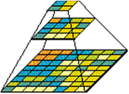
 When you build a pyramid, more rasters are created by progressively downsampling the previous level by a factor of two until the apex. As the application zooms out and the raster cells grow smaller than the resolution threshold, ArcSDE selects a higher level of the pyramid. The purpose of the pyramid is to optimize display performance.
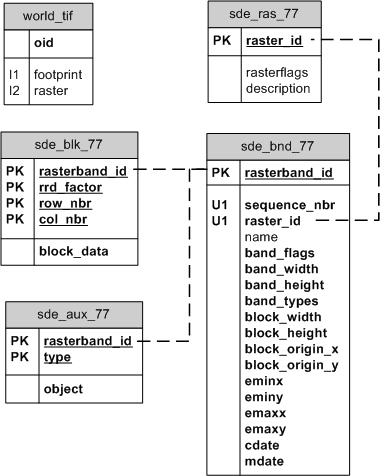
The following are the table definitions for the raster tables:
NOTE: You will only have the raster tables in your geodatabase if you have raster data in the geodatabase.
sde_aux_<raster_column_ID>The raster auxiliary table stores the image color map, image statistics, and the optional bit mask, which is used for image overlays and mosaicking.| Field name | Field type | Description |
|---|---|---|
| rasterband_id | Int | A number that represents a raster band; for example, a raster dataset with two raster bands would have two different values in this field—1 and 2 NOT NULL |
| type | Int | Values include 2 = raster statistics 3 = color map 4 = coordinate transformation 5 = reserved for geodatabase 6 = miscellaneous NOT NULL |
| object | Byte | Contains the actual data, either a color map index, raster statistics, or coordinate transformation NOT NULL |
| Field name | Field type | Description |
|---|---|---|
| rasterband_id | Int | A number that represents a raster band; for example, a raster dataset with two raster bands would have two different values in this field—1 and 2. NOT NULL. |
| rrd_factor | Int | Pyramid level. Pyramid levels begin at 0 and can increase from there. NOT NULL. |
| row_nbr | Int | Tile row number position. NOT NULL. |
| col_nbr | Int | Column row number position. NOT NULL. |
| block_data | Byte | Pixel data stored in the tile. NOT NULL. |
| Field name | Field type | Description |
|---|---|---|
| rasterband_id | Int | A number that represents a raster band; for example, a raster dataset with two raster bands would have two different values in this field—1 and 2 NOT NULL |
| sequence_nbr | Int | Sequence of the raster band within the raster dataset NOT NULL |
| raster_id | Int | The unique identifier of the raster dataset; corresponds to the value in the raster column that of the business table NOT NULL |
| name | Varchar(65) | The optional raster band name |
| band_flags | Int | A bitmask containing properties about the band NOT NULL |
| band_width | Int | The pixel width of the band NOT NULL |
| band_height | Int | The pixel height of the band NOT NULL |
| band_types | Int | A bit mask containing properties about the band NOT NULL |
| block_width | Int | The pixel width of a block NOT NULL |
| block_height | Int | The pixel height of a block NOT NULL |
| block_origin_x | Float | The x-ordinate of the raster origin NOT NULL |
| block_origin_y | Float | The y-ordinate of the raster origin NOT NULL |
| eminx | Float | The minimum x-value of a raster band; with eminy, emaxx, and emaxy, defines the envelope of a raster band NOT NULL |
| eminy | Float | The minimum y-value of a raster band; with eminx, emaxx, and emaxy, defines the envelope of a raster band NOT NULL |
| emaxx | Float | The maximum x-value of a raster band; with eminx, eminy, and emaxy, defines the envelope of a raster band NOT NULL |
| emaxy | Float | The maximum y-value in a raster band; with eminx, eminy, and emaxx, defines the envelope of a raster band NOT NULL |
| cdate | Int | The creation date of the raster band NOT NULL |
| mdate | Int | The last modification date of the raster band NOT NULL |
| Field name | Field type | Description |
|---|---|---|
| raster_id | Int | The unique identifier of the raster dataset; corresponds to the value in the raster column that of the business table NOT NULL |
| raster_flags | Int | Reserved for future use |
| description | Varchar(65) | The description of the raster dataset |
<esri:Workspace xmlns:esri="http://www.esri.com/schemas/ArcGIS/9.2" xmlns:xsi="http://www.w3.org/2001/XMLSchema-instance" xmlns:xs="http://www.w3.org/2001/XMLSchema">
  <WorkspaceDefinition xsi:type="esri:WorkspaceDefinition">
   <WorkspaceType>esriRemoteDatabaseWorkspace</WorkspaceType>
   <Version>sde.DEFAULT</Version>
   <Domains xsi:type="esri:ArrayOfDomain" />
   <DatasetDefinitions xsi:type="esri:ArrayOfDataElement">
     <DataElement xsi:type="esri:DERasterDataset">
       <CatalogPath>/V=sde.DEFAULT/RD=sde.RJP.world_TIF</CatalogPath>
       <Name>sde92.gdb.world_TIF</Name>
       <Children xsi:type="esri:ArrayOfDataElement">
          <DataElement xsi:type="esri:DERasterBand">
            <CatalogPath>/V=sde.DEFAULT/RD=sde92.gdb.world_TIF/RB=Band_1</CatalogPath>
            <Name>Band_1</Name>
            <DatasetType>esriDTRasterBand</DatasetType>
            <DSID>-1</DSID>
            <Versioned>false</Versioned>
            <CanVersion>false</CanVersion>
            <HasOID>true</HasOID>
            <OIDFieldName>ObjectID</OIDFieldName>
            <Fields xsi:type="esri:Fields">
              <FieldArray xsi:type="esri:ArrayOfField">
                <Field xsi:type="esri:Field">
                    <Name>ObjectID</Name>
                    <Type>esriFieldTypeOID</Type>
                    <IsNullable>false</IsNullable>
                    <Length>4</Length>
                    <Precision>0</Precision>
                    <Scale>0</Scale>
                    <Required>true</Required>
                    <Editable>false</Editable>
                </Field>
                <Field xsi:type="esri:Field">
                    <Name>Value</Name>
                    <Type>esriFieldTypeInteger</Type>
                    <IsNullable>true</IsNullable>
                    <Length>0</Length>
                    <Precision>0</Precision>
                    <Scale>0</Scale>
               </Field>
               <Field xsi:type="esri:Field">
                    <Name>Count</Name>
                    <Type>esriFieldTypeInteger</Type>
                    <IsNullable>true</IsNullable>
                    <Length>0</Length>
                    <Precision>0</Precision>
                    <Scale>0</Scale>
               </Field>
             </FieldArray>
         </Fields>
         <Indexes xsi:type="esri:Indexes">
           <IndexArray xsi:type="esri:ArrayOfIndex" />
         </Indexes>
         <IsInteger>true</IsInteger>
         <MeanCellHeight>0.175996089009095</MeanCellHeight>
         <MeanCellWidth>0.176000337991447</MeanCellWidth>
         <Height>1024</Height>
         <Width>2048</Width>
         <PixelType>U8</PixelType>
         <PrimaryField>1</PrimaryField>
         <TableType>esriRasterTableValue</TableType>
         <Extent xsi:type="esri:EnvelopeN">
            <XMin>-179.906382261841</XMin>
            <YMin>-90.1303147686327</YMin>
            <XMax>180.542309944643</XMax>
            <YMax>90.089680376681</YMax>
            <SpatialReference xsi:type="esri:GeographicCoordinateSystem">
   <WKT>GEOGCS["GCS_WGS_1984",DATUM["D_WGS_1984",SPHEROID["WGS_1984",6378137.0,298.257223563]],PRIMEM["Greenwich",0.0],UNIT["Degree",0.0174532925199433]]</WKT>
          <XOrigin>-400</XOrigin>
          <YOrigin>-400</YOrigin>
          <XYScale>11258999068426.2</XYScale>
          <ZOrigin>0</ZOrigin>
          <ZScale>1</ZScale>
          <MOrigin>0</MOrigin>
          <MScale>1</MScale>
          <XYTolerance>8.98315284119521E-09</XYTolerance>
          <ZTolerance>2</ZTolerance>
          <MTolerance>2</MTolerance>
          <HighPrecision>true</HighPrecision>
          <LeftLongitude>-180</LeftLongitude>
         </SpatialReference>
        </Extent>
      </Data>
    </DatasetData>
   </WorkspaceData>
</esri:Workspace>