Used in
CONFIG REQUESTServers
Image Query Feature Extract ArcMapParent elements
SPATIALQUERYSyntax
| <SPATIALFILTER | Attribute Description Table |
| (r)relation="area_intersection | envelope_intersection" > (r)<ENVELOPE... /> [Or] (r)<MULTIPOINT... /> [Or] (r)<POLYGON... /> [Or] (r)<POLYLINE... /> [Or] <BUFFER... /> </SPATIALFILTER > | |
| (r): Attribute or child element is required. | |
Description
A spatial filter defines the envelope for a spatial query. The envelope can be a rectangle, point, line, polygon, or buffer.Restrictions
- One ENVELOPE, POLYLINE, POLYGON, or MULTIPOINT element is required. Only one of these elements can be used.
- Using MULTIPOINT as a filter against a point or line layer will yield no results. Instead, a small envelope should be generated around this point. The envelope can then be used as the filter. Similarly, POLYLINE used against a point will yield no results. If desired, an envelope can be generated around the line for use as a filter.
- When using relation="envelope_intersection" on ArcSDE layers, no features are returned when
- MULTIPOINT is used.
- a POLYLINE where all x-coordinates or all y-coordinates are the same.
Notes
- When "area_intersection" is used with relation, all features that partially or fully fall within the area of the filter are selected. This operation can take some time. To speed up processing, "envelope_intersection" can be used instead. This method checks to see if the bounding box of the filter overlaps any bounding boxes of the features in the layer. A much quicker search results, but the features found could fall outside the area of the filter. In the examples below, an oval shape is used as the filter. When "envelope_intersection" is used, features outside the filter can be selected even though they are far outside the filter.
Shape of spatial filter to select points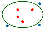
Points selected when relation="area_intersection"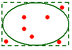
Points selected when relation="envelope_intersection"
Shape of spatial filter to select polygons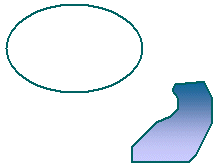
No polygons are selected when relation="area_intersection"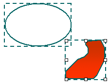
Polygon is selected when relation="envelope_intersection"
In general, it is recommended to use "area_intersection" to be certain you are retrieving the correct features. The value "envelope_intersection" should only be used in customized environments where you plan to retrieve a subset of features on which to run a second query using "area_intersection".
Attribute Descriptions for SPATIALFILTER
| Attribute | Usage |
|---|---|
| relation | Describes spatial relation. It is recommended to use "area_intersection". See Notes section for more details. |
Examples for SPATIALFILTER
Example 1: Note in this example that the DATASET fromlayer is "Countries". This refers to the LAYER id in the map configuration file, not the LAYER name.| <?xml version="1.0" encoding="UTF-8"?> <ARCXML version="1.1"> <REQUEST> <GET_IMAGE> <PROPERTIES> <ENVELOPE minx="-180" miny="-90" maxx="180" maxy="90" /> <IMAGESIZE width="643" height="502" /> </PROPERTIES> <LAYER type="featureclass" name="select layer" visible="true" id="300"> <DATASET fromlayer="Countries" /> <SPATIALQUERY> <SPATIALFILTER relation="area_intersection"> <ENVELOPE maxy="30" maxx="30" miny="0" minx="0" /> </SPATIALFILTER> </SPATIALQUERY> <SIMPLERENDERER> <SIMPLEPOLYGONSYMBOL fillcolor="255,255,255" filltype="cross" /> </SIMPLERENDERER> </LAYER> </GET_IMAGE> </REQUEST> </ARCXML> |
Back to top