Display


Display |
|
| Release 8 |
|
The Display tab is used to specify various display options in ArcPad.
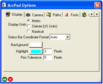
Tap the desired setting for distance units displayed in ArcPad: Metric, Statute (US Units), or Nautical. The selected setting is used in the following places:
Choose the format of the map coordinates displayed in the status bar: Auto—that is, let ArcPad decide the appropriate format— Projection, DMS, DMM, UTM, MGRS, or DD.
Default is Auto.
Tap the button to choose the desired background color for the Map View.
The default is white.
Tap the button to choose the color to use for highlighting selected features and enter the number of pixels to use for drawing the highlighted outline.
The defaults are cyan and 3 pixels.
Enter the maximum number of pixels that a mouse click or pen tap can be from a feature when identifying, hyperlinking, or selecting the feature. The pen tolerance also defines the size of vertices and sizing handles displayed when using the Vertex Edit tool.
The default is 5 pixels.