The Browse toolbar


The Browse toolbar |
|
| Release 8 |
|
The Browse toolbar consists of the following buttons:
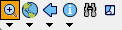
 Zoom In
 Zooms in on the map using the pen.
 Zoom
to Full Extent
Zoom
to Full ExtentZooms to the full extent of the map.
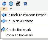
 Go Back to
Previous Extent
Go Back to
Previous ExtentZooms back to the previous extent you were viewing. ArcPad remembers the last 10 extents you have looked at since opening the map, so you can use this tool along with the Go To Next Extent tool to retrace your last 10 steps.
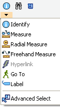
 Identify
Activates the identify tool. Displays the Feature Properties dialog box (or custom identify form if present) for any feature you tap while the Identify tool is active.
The Identify option (check box) must be turned on for a layer in the Table of Contents dialog box for a feature in that layer to be identified.
 Find
Find Opens the find tool.
Clears currently selected features.

Zoom In Zooms in on the map using the pen.
 Zoom Out
 Zooms out on the map using the pen.
 Pan
PanPans the map using the pen.
 Rotate Map
Sets the map rotation angle using the pen.
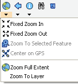
 Fixed Zoom In
Zooms in on the center of the map by 25 percent.
 Fixed Zoom Out
Zooms out on the center of the map by 25 percent.
 Zoom To
Selected
Zoom To
Selected Zooms to the extent of the selected feature.
 Center on GPS
Centers the map on the current GPS position.
Zoom
Full Extent Zooms to the full extent of all the layers in the map.
 Zoom To Layer
 Zooms to the extent of a particular layer in the map.
Go Back To
Previous ExtentZooms back to the previous extent you were viewing. ArcPad remembers the last 10 extents you have looked at since opening the map, so you can use this tool along with the Go To Next Extent tool to retrace your last 10 steps.
 Go To Next
Extent
Go To Next
Extent Zooms forward to the next extent in the extent history. ArcPad remembers the last 10 extents you have looked at since opening the map, so you can use this tool along with the Go Back To Previous Extent tool to retrace your last 10 steps.
 Create
Bookmark
Create
Bookmark Creates a spatial bookmark.
 Zoom To
Bookmark
Zoom To
Bookmark Zooms to an existing spatial bookmark.
Identify Activates the Identify tool. Displays the Feature Properties dialog box (or custom identify form if present) for any feature you tap while the Identify tool is active.
The Identify option (check box) must be turned on for a layer in the Table of Contents dialog box for a feature in that layer to be identified.
 Measure
 Measures distances in the map view in point mode. Tap the Proceed button on the Command bar to end and view the measurements.
 Radial Measure
 Measures radial distances in the map view using the pen.
 Freehand
Measure
Freehand
MeasureMeasures distances in the map view in freehand mode.
 Hyperlink
 Activates the Hyperlink tool. Launches the program associated with the Hyperlink field for the feature you tap while the Hyperlink tool is active.
A Hyperlink field must be specified for at least one layer in the map for the Hyperlink button to be active. Hyperlink fields are specified for a particular layer in the Hyperlink tab on the Layer Properties dialog box.
 Label
LabelActivates the Label tool.
Displays a label for the feature closest to the location of your tap. The label tool searches for the closest feature—using the layer order from the Table of Contents dialog box, and the display pen tolerance (from the ArcPad Options dialog box). The first feature found is labeled. Up to 10 labels are displayed—label 1 is removed when label 11 is displayed. “Nothing found!” is displayed in the status bar if no feature is found.
The label consists of a title and a comment.
The text for the title is determined in the following order: the contents of a field called NAME, TITLE, ID, or the first attribute field. The text for the comment is determined in the following order: the contents of a field called COMMENTS, DESCRIPTION, DESC, or DESCRIPTIO. No comment is displayed if none of these four fields exist.
Labels can be removed with the Clear Selected Feature tool.
 Go To
Go ToActivates the Go To tool. Sets the location you tap to be the current destination for navigation while the Go To tool is active.
 Advanced
Select
Advanced
Select