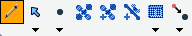
The Edit toolbar


The Edit toolbar |
|
| Release 8 |
|
The Edit toolbar consists of the following buttons:
 Start/Stop
Editing
Start/Stop
EditingThis tool is used to start/stop editing.
 Select
 Activates the Select tool. Selects any feature you tap and displays the Feature Properties dialog box—or custom edit form—for any feature you double-tap while the Select tool is active.
The Select button is only available when editing is turned on for one or more layers in the Start/Stop Editing drop-down list, or on the Table of Contents dialog box. Editing must be turned on for a layer in order for a feature in that layer to be selected.
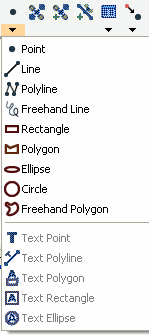
 Point
Point Activates the point feature type for data capture. Tap the map to add a point feature at the tapped location. The point feature type remains active for capture until another tool is activated.
The Point button is only available when editing is turned on for a point layer in the Start/Stop Editing drop-down list or on the Table of Contents dialog box.
 Capture Point using
GPS
Capture Point using
GPSCapture Point using GPS captures a point feature in the editable point layer using the current GPS position. The Capture Point using GPS button is independent of the feature type activated for capture. That is, you can capture a point feature using the current GPS position while you are capturing other line or polygon features.
The Capture Point Using GPS button is only available when the GPS is active and editing is turned on for a point layer in the Start/Stop Editing drop-down list or on the Table of Contents dialog box.
 Add GPS Vertex
 Captures a single vertex in the current line or polygon feature using the current GPS position. The Add GPS Vertex button is only available when the GPS is active and the polyline or polygon feature type is active for data capture.
 Add GPS
Vertices Continuously
Add GPS
Vertices Continuously Continuously captures vertices in the current line or polygon feature using the current GPS position. Tap this button again to pause vertex capture.
The Add GPS Vertices Continuously button is only available when the GPS is active and the polyline or polygon feature type is active for data capture.
 Feature
Properties
Feature
Properties Opens the Edit Form or Feature Properties dialog box for the selected feature.
The Properties button is only available when a feature is selected.
 Offset Point
 Activate offsets for point data capture.
The Offset Point button is only available when editing is turned on for a point layer in the Start/Stop Editing dropdown list or on the Table of Contents dialog box.

Select Activates the Select tool. Selects any feature you tap and displays the Feature Properties dialog box—or custom edit form—for any feature you double-tap while the Select tool is active.
The Select button is only available when editing is turned on for one or more layers in the Start/Stop Editing drop-down list, or on the Table of Contents dialog box. Editing must be turned on for a layer in order for a feature in that layer to be selected.
 Select & Vertex
Editing
Select & Vertex
Editing Activates the Select & Vertex Editing tool. Selects any feature you tap and displays the vertices for the selected feature.
The Select & Vertex Editing button is only available when editing is turned on for one or more layers in the Start/Stop Editing drop-down list or on the Table of Contents dialog box. Editing must be turned on for a layer in order for a feature in that layer to be selected.
 Select
at GPS Position
Select
at GPS Position Selects the feature at the current GPS coordinates.
The Select using GPS Position button is only available when the GPS is active.
 Center on Selected Feature
Centers the map on the selected feature without changing the current map scale.
 Zoom to
Selected feature
Zoom to
Selected featureZooms the map extent to the selected feature
 Go To
Selected feature
Go To
Selected featureGoto Sets the selected feature to be the current destination for navigation.
Clears currently selected features.
Point Activates the point feature type for data capture. Tap the map to add a point feature at the tapped location. The point feature type remains active for capture until another tool is activated.
The Point button is only available when editing is turned on for a point layer in the Start/Stop Editing drop-down list or on the Table of Contents dialog box.
 Line
Line Captures a straight-line feature. The Line button is only available when editing is turned on for a line layer in the Start/Stop Editing drop-down list or on the Table of Contents dialog box.
The Line button allows capture with the pen but not with incoming GPS coordinates.
 Polyline
 Activates the polyline feature type for data capture and starts a new line feature. The polyline feature type remains active for data capture until another tool is activated. Tap the map to add a vertex at the tapped location and tap the Add GPS Vertex button to add a vertex at the current GPS location. While the Add GPS Vertices Continuously button is depressed, vertices are continuously added at the current GPS location. The Polyline button is only available when editing is turned on for a line layer in the Start/Stop Editing drop-down list or on the Table of Contents dialog box. The Polyline button allows data capture with the pen as well as incoming GPS coordinates.
 Freehand Line
 Captures a freehand line feature using the pen.
The Freehand Line button is only available when editing is turned on for a line layer in the Start/Stop Editing drop-down list or on the Table of Contents dialog box.
The Freehand Line button allows data capture with the pen but not with incoming GPS coordinates.
 Rectangle
 Captures a rectangle polygon feature using the pen.
The Rectangle button is only available when editing is turned on for a polygon layer in the Start/Stop Editing drop-down list or on the Table of Contents dialog box.
The Rectangle button allows data capture with the pen but not with incoming GPS coordinates.
 Polygon
 Activates the polygon feature type for data capture and starts a new polygon feature. The polygon feature type remains active for data capture until until another tool is activated. Tap the map to add a vertex at the tapped location and tap the Add GPS Vertex button to add a vertex at the current GPS location. While the Add GPS Vertices Continuously button is depressed, vertices are continuously added at the current GPS location. The Polygon button is only available when editing is turned on for a polygon layer in the Start/Stop Editing drop-down list or on the Table of Contents dialog box. The Polygon button allows data capture with the pen as well as incoming GPS coordinates.
 Ellipse
 Captures an ellipse polygon feature using the pen.
The Ellipse button is only available when editing is turned on for a polygon layer in the Start/Stop Editing drop-down list or on the Table of Contents dialog box.
The Ellipse button allows data capture with the pen but not with incoming GPS coordinates.
 Circle
 Captures a circle polygon feature using the pen.
The Circle button is only available when editing is turned on for a polygon layer in the Start/Stop Editing drop-down list or on the Table of Contents dialog box.
The Circle button allows data capture with the pen but not with incoming GPS coordinates.
 Freehand
Polygon
Freehand
Polygon Captures a freehand polygon feature using the pen.
The Freehand Polygon button is only available when editing is turned on for a polygon layer in the Start/Stop Editing drop-down list or on the Table of Contents dialog box.
The Freehand Polygon button allows data capture with the pen but not with incoming GPS coordinates.
 Text Point
 Captures a text feature relative to a point, using the pen.
The Text Point button is only available when editing is turned on for a text or multi-feature layer, such as a graphics layer.
 Text Line
 Captures a text feature relative to a line, using the pen.
The Text Line button is only available when editing is turned on for a text or multi-feature layer, such as a graphics layer.
 Text Polygon
 Captures a text feature relative to a polygon, using the pen.
The Text Polygon button is only available when editing is turned on for a text or multi-feature layer, such as a graphics layer.
 Text Rectangle
 Captures a text feature relative to a rectangle, using the pen.
The Text Rectangle button is only available when editing is turned on for a text or multi-feature layer, such as a graphics layer.
 Text Ellipse
 Text Ellipse Captures a text feature relative to an ellipse, using the pen.
The Text Ellipse button is only available when editing is turned on for a text or multi-feature layer, such as a graphics layer.
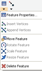
Feature
Properties Opens the Feature Properties dialog box—or custom edit form—for the selected feature. The Properties button is only available when a feature is selected.
 Insert
Vertices
Insert
Vertices Inserts new vertices in the selected polyline or polygon.
The Select & Vertex Editing tool is used to select the feature.
 Append
Vertices
Append
Vertices Append Vertices Adds new vertices to the end, or tail, of the selected polyline.
The Select & Vertex Editing tool is used to select the feature.
 Move Feature
 Moves the selected feature. The Select & Vertex Editing tool is used to select the feature.
 Rotate Feature
 Rotates the selected polyline or polygon feature. The Select & Vertex Editing tool is used to select the feature.
 Scale Feature
 Changes the size of the selected polyline or polygon feature relative to the original size. The Select & Vertex Editing tool is used to select the feature.
 Resize Feature
Changes the size of the selected polyline or polygon feature. The Select & Vertex Editing tool is used to select the feature.
 Delete Feature
 Deletes the selected feature.
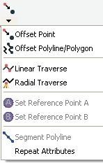
Offset Point Activates offsets for point data capture.
The Offset Point button is only available when editing is turned on for a point layer in the Start/Stop Editing dropdown list or on the Table of Contents dialog box
 Offset
Polyline/Polygon
Offset
Polyline/Polygon Activates left or right offsets for polyline or polygon data capture.
The Offset Polyline/Polygon button is only available when editing is turned on for a polyline or polygon layer in the Start/Stop Editing drop-down list or on the Table of Contents dialog box.
 Linear
Traverse
Linear
TraverseActivates the linear traverse mode for capturing a new polyline or polygon feature.
 Radial
Traverse
Radial
Traverse Activates the radial traverse mode for capturing a new polyline or polygon feature.
 Set
Reference Point A
Set
Reference Point A Activates the tool for setting a reference point A, to be used for capturing a point or vertex using a single point offset. The Set Reference Point A button is only available when either the Offset Point or Radial Traverse buttons are active.
 Set
Reference Point B
Set
Reference Point B Activates the tool for setting a reference point B, to be used for capturing a point or vertex using a two-point offset. The Set Reference Point B button is only available when a reference point A has been set. Begin Line Segment Repeat Attribute Value Activates copying of attributes from the previous feature to the new feature.
 Segment
Polyline
Segment
PolylineActivates adding new polylines that start at the end of the selected polyline. The Segment Polyline button is only available when a polyline is selected andt he Polyline tool is available.
 Repeat Attributes
 Activates copying of attributes from the previous feature to the new feature.