The Main toolbar


The Main toolbar |
|
| Release 8 |
|
The Main toolbar consists of the following buttons:

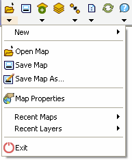
 Open Map
Opens an ArcPad map (a file with a .apm extension).
 Save Map
Saves the current ArcPad map.
 Add Layer
Adds one or more layers to the current map.
 Table of Contents
Opens the Table of Contents dialog box.
 GPS Active
Activates or deactivates the GPS.
 Options
Opens the ArcPad Options dialog box.
 Refresh
Redraws the map.
 Help
HelpDisplays a new submenu, consisting of all the help files (Quick Reference Help, User Guide, Reference Guide on Windows XP or Vista, or Quick Reference Guide only on Windows Mobile) and a link to ESRI Suport Center. It also displays information about StreetMap Extension and about ArcPad.
Displays a submenu for creating a new QuickProject, map, shapefile, QuickForm, graphics layer, or photo layer.
Open MapOpens an ArcPad map (a file with a .apm extension)
Save MapSaves the current ArcPad map.
 Save Map As
Saves the current ArcPad map with a new name and/or in a different folder.
 Map Properties
Opens the Map Properties dialog box.
Displays the nine most recently opened maps. Tap any one of these to close the current map and open the selected map.
Displays the nine most recently added layers. Tap any one of these to add the selected layer to the current map.
 Exit
Exit Closes ArcPad
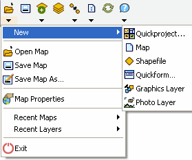
 Quick Project
Closes the current map and creates a new data capture project with ready-to-use point, polyline, and polygon shapefiles. Layers in the current map can optionally be added to the new QuickProject map.
 Map
Map Closes the current map and creates a new, blank map.
 Shapefile
Creates a new shapefile, with an optional QuickForm, and loads it into the current map.
 QuickForm
 Creates a new QuickForm for an existing shapefile.
 Graphics Layer
Creates a new graphics layer and loads it into the current map.
 Photo Layer
Creates a new photo layer and loads it into the current map.
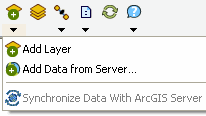
Add LayerAdds one or more layers into the current map.
 Add Data
from Server
Add Data
from ServerAdd an ArcGIS Server ArcPad Service or ArcIMS® image service as a layer to the current map.
 Synchronize Data With
ArcGIS Server
Synchronize Data With
ArcGIS ServerUpload and download data to and from an ArcGIS Server ArcPad Service.
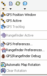
 GPS Position
Window
GPS Position
WindowOpens or closes the GPS Position Window GPS Active Activates or deactivates the GPS.
GPS ActiveActivates or deactivates the GPS.
 GPS Tracklog
Starts or stops storing GPS points in the tracklog shapefile.
 Rangefinder Active
Activates or deactivates the rangefinder.
 GPS
Preferences
GPS
PreferencesOpens the GPS Preferences dialog box.
Rangefinder
PreferencesOpens the RangeFinder Preferences dialog box.
 GPS/Rangefinder Debug
Opens or closes the GPS and Rangefinder Debug Window.
 Automatic Map Rotation
Activates or deactivates the automatic rotation of the map based on the GPS direction of movement (or Course Over Ground, COG). When activated, the top of the map is aligned with the GPS direction of movement.
Clears the map rotation so that the map constantly faces north.
OptionsOpens the ArcPad Options dialog box
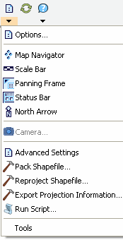
 Map Navigator
Displays or hides the Map Navigator.
 Scale Bar
Displays or hides the scale bar.
 Panning Frame
Displays or hides the map panning frame.
 Status Bar
Displays or hides the status bar.
 North Arrow
 Displays or hides the north arrow in the map view
 Camera
Opens the camera tool for taking stand-alone photographs with the connected camera.
Advanced Settings Opens the Advanced Settings dialog box.
 Pack Shapefile
 Packs a shapefile by removing records flagged for deletion.
Reproject ShapefileReprojects a shapefile to another projection and/or datum.
Export Projection
InformationExports ArcPad projection information into CSV and text files.
 Run Script
Opens the Script dialog box, which can be used for testing scripts.
This sub menu allows you to open and access properties of ArcPad extensions.
RefreshRefreshes your current map.
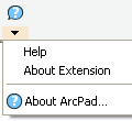
Lists available Help documents (varies dependant upon operating system).
Opens the About ArcPad Street Map Extension dialog box.
 About ArcPad
Opens the About ArcPad dialog box.

 Quick Reference
Help
Quick Reference
Help Displays the Quick Reference Help. (On the PC, opens the ArcPad Quick Reference pdf, on Windows Mobile opens the ArcPad htm Help.)
 Reference Guide
On the PC, opens the ArcPad Reference Guide.
User Guide On the PC, opens the ArcPad User Guide.
 ESRI
Support Center
ESRI
Support CenterGoes to the support.esri.com web site, using the default Internet browser.