The StreetMap toolbar


The StreetMap toolbar |
|
| Release 8 |
|
The StreetMap toolbar is automatically displayed after a StreetMap layer is loaded into the ArcPad map, and is automatically closed after the StreetMap layer is removed from the ArcPad map.
The StreetMap toolbar consists of the following buttons:
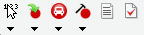
 Find Location
Reverse geocodes a location
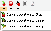
 Convert Location to
Stop
Convert Location to
StopConverts the current location to a stop.
 Create Route from Stops
Finds a route between stop points while preserving the order of the stops.
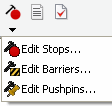
 Edit Stops
Opens the Edit Stops dialog box, which allows you to change the order of stops, temporarily disable stops, and delete stops.
 Driving Directions
Displays or hides driving directions for the current route.
 StreetMap Preferences
Opens the StreetMap Preferences dialog box.
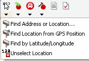
 Find Address or Location
Opens a dialog box for finding an address, city, or latitudelongitude coordinate.
 Find Location from GPS
Position
Find Location from GPS
PositionFinds a location using the current GPS position.
Find by Latitude and LongitudeFinds a location using the current GPS position.
 Unselect Location
Removes the location selection from the map.
Convert Location to
StopConverts the current location to a stop.
 Convert Location to
Barrier
Convert Location to
BarrierConverts the current location to a barrier.
 Convert Location to
Pushpin
Convert Location to
PushpinConverts the current location to a pushpin.
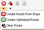
Create Route from StopsFinds a route between stop points while preserving the order of the stops.
 Create Optimized Route
Finds a route between stop points by reordering intermediate locations.
Removes a calculated route from the map.
Edit StopsOpens the Edit Stops dialog box, which allows you to manage the order of stops, temporarily disable stops, and delete stops.
 Edit Barriers
Opens the Edit Barriers dialog box, which allows you to edit properties of barriers, temporarily disable barriers, and delete barriers.
 Edit Pushpins
Opens the Edit Pushpins dialog box, which allows you to edit properties of pushpins, disable pushpins, and delete pushpins.