ArcIMS


ArcIMS |
|
| Release 8 |
|
The ArcIMS tab lists and displays information about all the sublayers in the ArcIMS layer. The sublayers are the individual layers available in the ArcIMS image service.
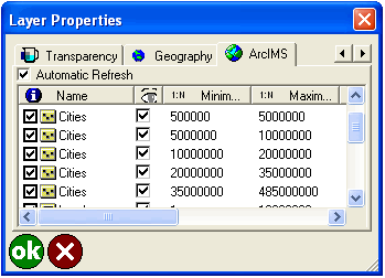
When checked, the ArcIMS layer is reloaded from the server whenever the map scale changes or the map is refreshed. When unchecked, the ArcIMS layer is only reloaded when the Refresh button on the Browse toolbar is tapped.
It is recommended that you uncheck this option when using a slow Internet connection.
The default is checked.

When checked, the Identify tool is active for this sublayer.
When unchecked, the Identify tool is inactive for this sublayer.
The default is checked.
Displays the name of each sublayer.
This is a display-only field.

When checked, this sublayer is visible. When unchecked, this sublayer is not visible. The visibility of each sublayer is specified by the ArcIMS service and cannot be changed in ArcPad.
This is a display-only field.
Shows the minimum map scale—based on the ArcIMS definition—that the sublayer is displayed at. If the map is zoomed in beyond this scale, the sublayer is not displayed.
This is a display-only field.
Shows the maximum map scale—based on the ArcIMS definition—that the sublayer is displayed at. If the map is zoomed out beyond this scale, the sublayer is not displayed. This is a display-only field.
Displays the minimum x-coordinate of the sublayer’s extent in map projection units.
This is a display-only field.
Displays the minimum y-coordinate of the sublayer’s extent in map projection units.
This is a display-only field.
Displays the maximum x-coordinate of the sublayer’s extent in map projection units.
This is a display-only field.
Displays the maximum y-coordinate of the sublayer’s extent in map projection units.
This is a display-only field.