Snapping


Snapping |
|
| Release 8 |
|
The Snapping tab is used to specify snapping settings that are applicable to all layers in the current map.
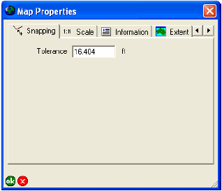
Enter the maximum distance within which snapping occurs between points, vertices, or lines. The snapping tolerance uses the display units, which are set on the Display tab of the ArcPad Options dialog box.
The snapping tolerance is applied to all layers in the current map, unless a snapping tolerance has been specifically set for a particular layer on the Snapping tab of the Table of Contents dialog box.
The default is 5 m, or 16.404 feet.