Layers


Layers |
|
| Release 8 |
|
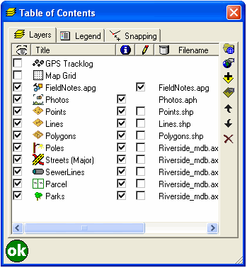
The Layers tab displays all the layers in the current ArcPad map, including the built-in GPS Tracklog and Map Grid layers. The layers in the map are drawn in reverse order, i.e. layers are drawn from the bottom of the layers list to the top. From the Layers tab, layers can be added and removed from the map, and the order of these layers can be changed. The visibility of the layers can be turned on or off, and layers can be activated for editing or the Identify command. The Layer Properties dialog box can be opened to view and change various properties for the selected layer.
ArcPad displays icons together with layer names to make it easier to differentiate between layers. Display of layer icons can be seen throughout the ArcPad user interface, including on the Table of Contents dialog box and Add Layers dialog box, and in the Start/ Stop Editing tool. ArcPad supports two different types of layer icons: standard and custom icons. ArcPad uses the following standard icons for each layer type:
 GPS Tracklog.
 Map Grid.
 Point shapefile or
ArcPad AXF layer with no layer definition file (.APL).
Point shapefile or
ArcPad AXF layer with no layer definition file (.APL).
 Point shapefile or ArcPad
AXF layer that has an associated layer definition file. The layer definition file
can include any form of customization, such as custom forms or custom symbology.
Point shapefile or ArcPad
AXF layer that has an associated layer definition file. The layer definition file
can include any form of customization, such as custom forms or custom symbology.
 Polyline shapefile
or ArcPad AXF layer with no layer definition file.
Polyline shapefile
or ArcPad AXF layer with no layer definition file.
 Polyline shapefile or
ArcPad AXF layer that has an associated layer definition file.
Polyline shapefile or
ArcPad AXF layer that has an associated layer definition file.
 Polygon
shapefile or ArcPad AXF layer with no layer definition file.
Polygon
shapefile or ArcPad AXF layer with no layer definition file.
 Polygon shapefile or
ArcPad AXF layer that has an associated layer definition file.
Polygon shapefile or
ArcPad AXF layer that has an associated layer definition file.
 Multi-feature
layer, such as a graphics layer.
Multi-feature
layer, such as a graphics layer.
 Image layer.
 Photo layer.
 StreetMap layer.
To associate a custom layer icon with a shapefile, place any 16x16 pixel Windows icon
file (.ICO) in the same folder as the shapefile it is to be associated with and
rename the icon file with the same prefix as the shapefile. For example, to
associate an icon, such as  ,
with a shapefile roads.shp, rename the icon file roads.ico.
,
with a shapefile roads.shp, rename the icon file roads.ico.
To associate an icon with an ArcPad AXF layer, right-click the feature layer (in ArcPad Studio) and choose Set Layer Icon. Browse to the icon file and click Open. These custom icons will then be used by ArcPad instead of the standard layer icons.
There are many sources of icon files on the Internet, or you can create your own. ArcPad includes a variety of icons in the Samples folder located in the ArcPad installation folder.

When checked, the layer is drawn on the ArcPad map, provided the map scale is within the range specified on the Scale tab of the layer’s Layer Properties dialog box.
When unchecked, the layer is not be drawn, provided the layer is not active for editing.
Tapping toggles the
visibility for all layers on or off, except for the built-in GPS Tracklog and Map
Grid layers.
The default is unchecked for the built-in GPS Tracklog and Map Grid layers and checked for new layers added to the map. The layer visibility settings in the ArcPad map file (.apm) override the default settings.
This displays the name of each layer, as defined on the Information tab of the Layer Properties dialog box. Double-tapping a layer opens the Layer Properties dialog box for the layer.
This is a display-only field.

When checked, the layer is active for querying with the Identify and Advanced Select tools.
When unchecked, the layer is not active for Identify or Advanced Select.
Tapping toggles Identify on or
off for all layers.
The default is checked for new layers added to the map. The layer Identify settings in the ArcPad map file (.apm) override the default settings.

When checked, the layer is active for editing.
When unchecked, the layer is not active for editing.
Layers can also be activated or deactivated for editing by using the Start/Stop Editing tool on the Browse toolbar.
Layers without a corresponding Edit check box are not editable in ArcPad. Layers are not editable due to one of two reasons:
Up to three layers can be active for editing, but only one layer of each feature type can be active for editing at a time, in other words, one point feature layer, one line feature layer, and one polygon feature layer. Graphics layers can include point, line, and polygon features. If a graphics layer is made editable, all other layers are deactivated for editing. If a graphics layer is active for editing, and another shapefile layer is activated for editing, the matching feature type within the graphics layer is deactivated for editing. For example, if a graphics layer is editable and subsequently a point layer is activated for editing, only the line and polygon feature types within the graphics layer are editable.
The default is unchecked for new layers added to the map and checked for new layers created and added to the map using the New submenu of the Main toolbar. The layer edit settings in the ArcPad map file (.apm) override the default settings.
This displays the location, or folder, where the layer file is stored on the device.
This is a display-only field.

Tap to select a projection file (.prj) for ArcPad to use for the current map’s coordinate system and projection parameters.

Tap to open the Map Properties dialog box. The Map Properties dialog box is described in section Map Properties of this reference guide.

Tap to open the Add Layers dialog box to select layers to be added to the current map.

Tap to open the Layer Properties dialog box to view and change various properties for the selected layer. The Layer Properties dialog box is described in section Layer Properties of this reference guide.

Tap to move the layer up one position in the layer drawing order.

Tap to move the layer down one position in the layer drawing order.

Tap this to remove the selected layer.