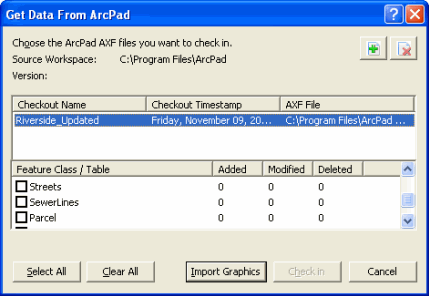
Get Data from ArcPad


Get Data from ArcPad |
|
| Release 8 |


|
This tool allows you to check in the edits made in ArcPad back into the geodatabase from which the data was checked out. You can also import ArcPad graphics files into ArcMap’s graphics layer.
You can check in edits from one or more ArcPad AXF files at a time, and from one or more feature classes at a time—allowing for a flexible field to office workflow. Summaries of all added, modified, and deleted features are presented for each feature class and its related tables.
All edits on related table records are checked in when their parent feature classes are checked in. All edits that occurred in ArcPad, including adding features and related table records; deleting features and records; modifying attribute values; and changing feature geometry can be checked back into the geodatabase. Edits are replayed to the geodatabase in the same order as they occurred in ArcPad.

Add ArcPad AXF file

Click to open the Select ArcPad File(s) dialog box for selecting an ArcPad AXF file to check in.
Remove ArcPad AXF file 
Click to remove the selected ArcPad AXF file from the Get Data From ArcPad tool.
Checkout Name
Displays the name of the ArcPad AXF file.
Checkout Timestamp
Displays the date and time that the ArcPad AXF was created.
AXF File
Displays the folder location of the ArcPad AXF file.
Feature Class / Table
Check to select the feature class (and any associated related tables) to be checked in. Selecting the feature class automatically selects the associated related tables.
Added
Displays the number of new features and records that were added to the feature class and related tables in ArcPad.
Modified
Displays the number of features and records that were modified in ArcPad. These modifications include both geometry and attribute changes.
Deleted
Displays the number of features and records that were deleted from the feature class in ArcPad.
Select All
Selects all of the feature classes.
Clear All
Clears all the checkboxes for check in.
Import Graphics
Click to import ArcPad graphics files into ArcMap’s graphics layer
Check in
Click to perform the check in on the selected feature classes and related tables.