The GPS/Rangefinder Debug tool


The GPS/Rangefinder Debug tool |
|
| Release 8 |
|
GPS/Rangefinder Debug is a useful tool for troubleshooting GPS connection problems. The GPS/Rangefinder Debug tool is opened by tapping the arrow to the right of the GPS Position Window button and then tapping GPS/Rangefinder Debug. The GPS Debug tool is only opened when a GPS or rangefinder is currently active.
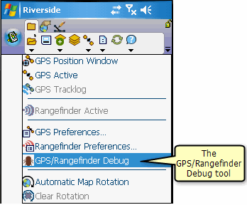
The GPS/Rangefinder Debug tool opens a window that displays data from either the GPS receiver or rangefinder, or both. ArcPad uses the settings for the GPS and rangefinder communication parameters to parse, or interpret, the GPS and/or rangefinder data being received on the serial port of your device. The information displayed in the GPS/Rangefinder Debug window is dependent of the GPS and rangefinder protocols being used to communicate with your GPS receiver or rangefinder. ArcPad then displays information in the GPS/Rangefinder Debug window that indicates the status of the GPS and/or rangefinder connection.
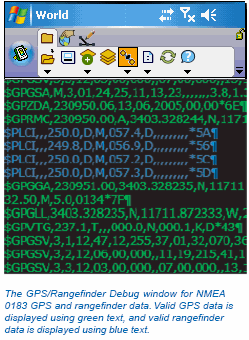
Valid GPS data is displayed in green text, and valid rangefinder data is displayed in blue text. Invalid data is displayed in red text. Valid data is data that is constructed properly, in accordance with the selected GPS or rangefinder protocol, and has a valid checksum.
‘Using your rangefinder’, includes a section on using the GPS/Rangefinder Debug tool for troubleshooting your rangefinder connection. This section will focus on using the tool for troubleshooting your GPS connection.
Irrespective of which GPS protocol is being used, the first observation to make when opening the GPS/Rangefinder Debug window is whether any information is being displayed at all. No information displayed in the GPS/Rangefinder Debug window indicates a GPS connection or configuration problem. Problems are caused by any one of the following factors:
Test each of these factors one by one to isolate the problem and determine why no information is being displayed in the GPS/ Rangefinder Debug window.
If you have not already done so, run the Find GPS tool—which is located on the GPS page of the GPS Preferences dialog box.
It is worthwhile to note that some GPS receivers have quality controls set—such as PDOP, HDOP, and Elevation Mask angles—which could affect the output of the GPS receiver. Although these settings would not typically be the reason for no information displayed in the GPS/Rangefinder Debug window, these settings could explain why your GPS receiver is not reporting a coordinate to ArcPad. It may be useful to confirm that these parameters on your GPS receiver are set to minimal levels when experiencing difficulties obtaining a coordinate from your GPS.
In some instances you may see illegible characters displayed in the GPS/Rangefinder Debug window. This is usually caused by GPS port communication parameters selected in the GPS Preferences dialog box that do not match the serial communication parameters set on your GPS receiver.
If you are using the NMEA 0183 protocol, you should see the NMEA 0183 sentences displayed in the GPS/Rangefinder Debug window as ASCII text. Each NMEA sentence that ArcPad reads from the serial port is displayed in the GPS Debug window. Valid GPS data is displayed using green text, while invalid GPS data is displayed using red text.
The displayed NMEA 0183 sentences can be used to troubleshoot your GPS connection. In the following example, a number of the NMEA 0183 sentences are displayed showing empty fields with commas and no preceding information.
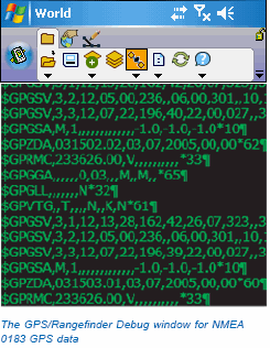
For instance, the $GPGGA sentence (in the middle of the GPS/ Rangefinder Debug window) is displayed as:
$GPGGA,,,,,,0,03,,,M,,M,,*65
The $GPGGA NMEA 0183 sentence includes the GPS fix data, with the first field containing the UTC time, the second and third fields containing the latitude, the fourth and fifth fields containing the longitude, the sixth field containing the fix quality, and the seventh field containing the number of satellites being tracked. In the above example $GPGGA NMEA 0183 sentence, the UTC time, latitude, and longitude values are empty. The fix quality field is 0, which means there is no GPS fix. The number of satellites being tracked is 3, which is insufficient to calculate a position (4 satellites are needed to calculate a position. So the absence of latitude and longitude values and the fix quality of 0— that is, no fix—indicate that the GPS receiver has not locked on to sufficient satellites to calculate a GPS position and consequently is not outputting a GPS position to ArcPad. This would explain why, in this situation, ArcPad does not display a GPS position in the GPS Position Window.
Similarly, empty fields in other NMEA 0183 sentences can explain why the corresponding information is not displayed in the GPS Position Window.
The TSIP protocol is quite different to the NMEA 0183 protocol. First, the TSIP protocol is a binary protocol in which the GPS data is sent in a binary format as data packets of information. This binary data is illegible and needs to be decoded by a computer program. Consequently, the TSIP packet contents are not shown in the GPS/Rangefinder Debug window, but instead a message is displayed showing the TSIP packet number, a description of the contents of the packet, and whether ArcPad has received the packet without errors. Packets that have been successfully received are displayed using green text. Packets that have not been successfully received are displayed using red text.
Second, with the TSIP protocol, some of the GPS data is only sent by the GPS receiver when it receives a request to do so. For example, ArcPad needs to send the TSIP packet 0x003C, Request Tracking Status, to the GPS receiver to receive the packet 0x005C, Satellite tracking status, in return.
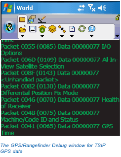
In the example above, all of the TSIP packets have been successfully received, and are all displayed using green text.
The TSIP packet messages in the GPS/Rangefinder Debug window can be used to troubleshoot your GPS connection in the same way as the NMEA 0183 sentences. Missing information in the GPS Position Window can usually be explained by a TSIP packet that ArcPad has requested but has not yet received.