Adding ArcIMS layers to your ArcPad map


Adding ArcIMS layers to your ArcPad map |
|
| Release 8 |
|
ArcIMS layers are displayed as Geography Network Definition files with a .gnd suffix. These allow you to refresh the layer from the Internet server where you originally retrieved it. The image layer received from the ArcIMS image service is stored locally.
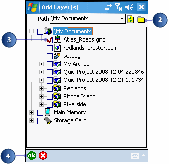
A red check mark indicates selected files. If you check the .jpg layer, you are adding the last image requested from the ArcIMS service. If you check the .gnd layer, you can refresh the layer for the most current data. You should only select one.
Your ArcIMS layers are added to the existing ArcPad map.