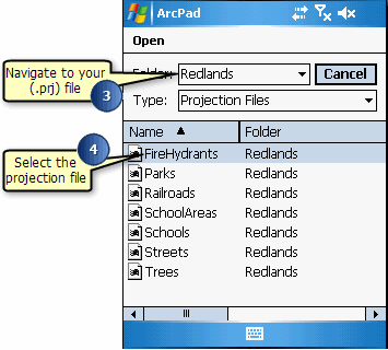
Steps to specify a coordinate system

Release 8 E-mail This Topic Printable Version Give Us Feedback

  1. Tap the Table of Contents button, on the main toolbar.

  2. Tap Choose Map Projection Definition File.
  3. Navigate to the location of your projection file (.prj) on the Choose Map Projection Definition File dialog box.

  4. Select the projection file that matches the projection of the layers in your current map.

    The coordinate system has been specified. View the Projection page in the Map Properties dialog box to display the coordinate system of the current map.