Working with attributes


Working with attributes |
|
| Release 8 |
|
Attributes for features in shapefiles and ArcPad AXF files are displayed in the Feature Properties dialog box. For new features, the Feature Properties dialog box is automatically displayed once the geometry of the new feature has been captured. For existing features, the Feature Properties dialog box can be displayed by selecting the feature and then either tapping the Feature Properties button on the Edit toolbar, or double-tapping the selected feature.
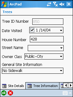
The Feature Properties dialog box will, by default, contain the Attributes, Picture, Symbology, and Geography pages. However, if a custom edit form exists for the particular layer then this form will be displayed as the first page, or pages, of the Feature Properties dialog box. The custom form designer may choose to hide any of the default pages. The example below shows a custom edit form with two custom pages: Site Details, and Tree Information. The name of the Feature Properties dialog box has also been renamed, to ‘Trees’, by the form designer.
You can create custom forms for shapefile and ArcPad AXF layers by using ArcPad Studio. These custom forms allow you to display attributes using common form controls—for example, text boxes, combo boxes, and check boxes—and incorporate additional data validation and initialization of attributes.
The first page of the Feature Properties dialog box is the parent page. The parent page
will either be the first page of a custom form, or the Attributes page if no custom form
exists. All other pages of the Feature Properties dialog box are considered child pages.
Each child page has an Up  button
located next to the OK and Cancel buttons. Tapping the Up button jumps to the parent
page.
button
located next to the OK and Cancel buttons. Tapping the Up button jumps to the parent
page.
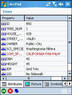
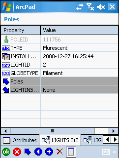
The Attributes page is used to display and edit the attributes and associated values of the selected feature. When accessed via the Identify tool, all values are read only. When accessed via the Feature Properties tool—or by double-tapping a feature with the Select tool—all values are read/write. An attribute that is used to define the symbology of the layer is displayed in red.
The Attributes page for shapefile features has two columns: Property and Value. The Property column corresponds to the field, or column, in the dBase table associated with the shapefile. The value column contains the value of the associated field or column. Tapping the value opens an edit box for editing the value entry.
With shapefiles, validation of the data entered is limited to adherence to the definition of the field or property. For example, ArcPad will not allow text characters to be entered into a field which has been defined as numeric. Additional validation can also be performed via custom forms and, in some cases, scripts.
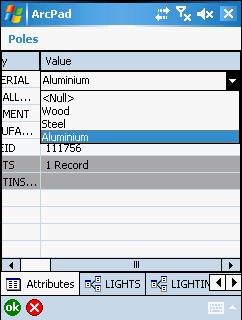
The Attributes page for ArcPad AXF features has two columns: Property and Value. ArcPad AXF files support viewing and editing of related tables. The Attributes page for AXF features will also include a row for each relationship (or related table) that has been defined for the AXF feature layer.

Primary related tables, i.e tables that have a direct relationship with the attribute
table, are indicated by a single Down  button.
Secondary related tables, i.e. tables that have a relationship with a primary related
table, are indicated by a double Down  button. The double Down button arrows indicate that the
relationship is two-levels down, for example LightInspections are related to Lights,
which are related to Poles.
button. The double Down button arrows indicate that the
relationship is two-levels down, for example LightInspections are related to Lights,
which are related to Poles.
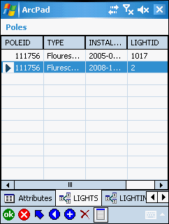
The related table row lists the name of the relationship, the number of records (or
entries) in the primary related table, and a down button or double Down button to easily nagivate
to the Attributes page for the corresponding related table.
Tapping the value opens an edit box for editing the value entry, or activates a drop-down list to select from pre-defined valid values.
The value field for AXF layers and related tables may include built-in form controls—such as combo boxes (or pick lists)—if subtypes or coded value domains have been defined for the source geodatabase which the AXF layer was extracted from.
Validation of the data in AXF feature tables and related tables takes place at two levels:
Domains are defined as part of the AXF database schema. The schema can be defined for the geodatabase in ArcCatalog (ArcGIS Desktop). The ArcPad Data Manager for ArcGIS Desktop reads the geodatabase schema and then creates the corresponding schema for the output AXF file. ArcPad Studio can also be used to view the schema for AXF files.
The attributes page for related tables is similar to the Attributes page, with the following differences:
button, at the bottom of the page, which jumps to the parent page. If the
relationship is with the feature attribute table then the parent page is the
Attributes page or the first page of a custom form. If the relationship is
with another related table, then the parent page is this related table.The related table list view consists of a list of records and columns in the table, with one row per record. Rows or records can be added or deleted in the list view, but the record contents cannot be edited.
The list view has the following buttons at the bottom of the page (in addition to the previously described ok, Cancel, and Up buttons):
 Moves the selection up one row
 Moves the selection down one
row
Moves the selection down one
row
 Adds a new row and then
automatically switches to the single entry view.
Adds a new row and then
automatically switches to the single entry view.
 Deletes the selected row
 Switches to the single row
view.
Switches to the single row
view.
The single row view has two columns: Property and Value. The data can be edited in
the single row view. This view also includes rows for the parent table and any
secondary related tables. The Up button can be used to easily navigate to the parent table,
while the Down button can
be used to easily nagivate to any secondary related tables.
Tapping the value opens an edit box for editing the value entry, or activates a drop-down list to select from pre-defined valid values.
The single row view has the following buttons at the bottom of the page:
Moves the selection up one row
Moves the selection down one
row
Adds a new row and then
automatically switches to the single entry view.
Deletes the selected row
Switches to the single row
view.
The Symbology page is used to view the symbols and labels defined in the ArcPad layer definition. The ArcPad layer file is created in ArcGIS Desktop using the ArcPad Data Manager. ArcPad assigns a random symbol for the layer if there is no symbology defined in the layer file. The symbol used by the currently selected feature is highlighted.
The Symbology page provides a visual method for selecting an attribute value. When a symbol, or category, is selected the associated property value is also selected for the current feature’s attributes. The example below shows the selection of the ZoneCode property equal to a value of 5. The Label text is for display purposes only, and is not saved in the feature’s attributes.
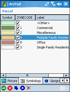
You can add a new category by tapping the button at the bottom of the legend. Each new category consists
of a symbol, value, and label. You can also delete a category by selecting the
category and tapping the
button. Adding or deleting categories changes the symbology, or legend, used to
display the features in the associated feature layer—adding or deleting categories
has no impact on the attributes saved with features.