Creating a line feature using the Polyline tool and the pen


Creating a line feature using the Polyline tool and the pen |
|
| Release 8 |
|
The vertices are drawn with a blue box.

Continue to tap the map to capture additional vertices.
Go to Step 7 to complete the capture of the new line feature, or continue to Step 4 to use the capture menu to add more vertices.

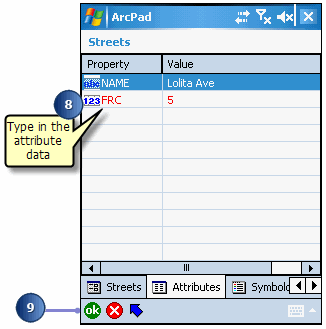
The Feature Properties dialog box or custom edit form is automatically displayed after the new line feature has been created.
For example, tap the Value field for the NAME Property to open the associated Value text box and type the street name value of “Lolita Ave”.
Determining the length of a line feature: You can determine the length of a selected line feature by opening the Geography page of the Feature Properties dialog box. ArcPad dynamically calculates the length of the selected line and displays it in the Geography tab using the Display Units. The length is not stored with the feature’s attributes.