User Interface Components: Geoportal Extension Web Application


User Interface Components: Geoportal Extension Web Application |
|
| Release 9.3.1 |
|
The user interface of the Geoportal extension utilizes the JavaServer Faces (JSF) framework. Requests from website pages are processed by Faces and routed to the appropriate Geoportal extension controller for execution. Following execution, Faces navigates to the appropriate page to render the response. Controllers and navigation rules are configured within \\geoportal\WEB-INF\gpt-faces-config.xml.
The layout for website pages is based upon the Apache Struts Tiles framework. Tiles define the page template, allowing for consistency across all pages. Tile definitions are configured within \\geoportal\WEB-INF\tiles-defs.xml and implemented within \\geoportal\catalog\skins\centeredLayout.jsp. For more about the tiles framework, see Geoportal Extension Layout and Tiles.
The style for website pages (colors, fonts, etc.) is based upon a Cascading Style Sheet (CSS) and a corresponding set of graphics (by default: \\geoportal\catalog\skins\red\main.css and \\geoportal\catalog\skins\red\images).
The primary user interface components associated with the operation, look and feel, and localizable content for the Geoportal extension Web Application is depicted in the figure below.
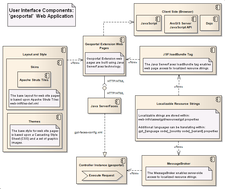
User interface strings are localizable. All strings (with the exception of low level error messages and user supplied content) are retrieved from a Java resource bundle. The bundle can be translated into another language and named as follows: \\geoportal\WEB-INF\classes\Geoportal Extension_[language code]_[country code]_[variant].properties. See section on localization in the customization section of webhelp.
The website utilizes JavaScript for any client side (i.e. browser side) programming. The Dojo toolkit (a JavaScript framework) is utilized for more complex interactions (e.g. AJAX calls). The website utilizes the ArcGIS JavaScript API when implementing GIS-related functionality on a Geoportal extension Web Application page. Examples include: the display of interactive maps, interaction with geographic locator services, interaction with the Geoportal extension Data Download service, and the projection of geographic primitives.
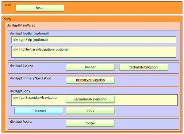
The Geoportal interface is built using Apache Tiles. Apache Tiles is a templating framework for web application user interface development. Authors can define a web application page in fragments, which are assembled into the complete page at runtime. For more information see http://tiles.apache.org
Tiles are assembled together into a layout. Most pages of the Geoportal interface are drawn using the "centered layout". The centered layout is defined by the \\geoportal\catalog\skins\centeredLayout.jsp file. Two other layouts are defined in an out-of-the- box Geoportal installation: a minimal centered layout and a popup layout. These are used in a few instances on certain pages where the full layout and navigation is not required.
The tiles that make up each layout are identified in the \\geoportal\WEB-INF\tiles-defs.xml file.
The graphic below shows the structure of the centered layout, and the organization of the tiles within in. In the graphic, the head and body sections refer to standard HTML head and body tags, the div sections refer to standard HTML div tags, and all of the green boxes (rightmost in most cases) represent a tile.
Geoportal Tiles
The following is a description of the content and purpose of each tile that makes up the geoportal interface.