An image overlay is an image file that can be drawn onto the map display, primarily to support presentations; for example, you can add .png, .bmp, .tiff, .jpg, and .gif files that represent legends, logos, advisory text such as "Confidential" or "Draft", .png copies of PowerPoint slides, graphics that frame the display or other information. You can add any number of image overlays to the map. All image overlays display in front of any layers, notes, and the basemap; you can position, resize, set a transparent color, and change the display order of any image overlays in relation to each other. Any transparency originally stored in the image is maintained. The image file specified can be a file on disk or a file on a Web server.
To add an image overlay to the map
On the Home tab, in the Map group, click Add Content and then click Image Overlays... or Image Overlay Network Link.... You'll see a dialog you can use to browse for image files or enter a URL to an image.
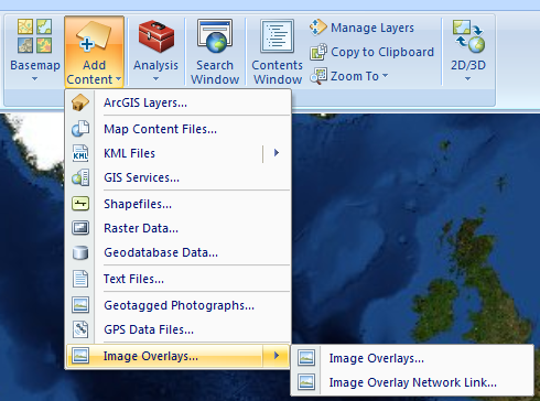 Click Open or Add to add the overlay to the map. If you add an Image Overlay network link the URL to the image is stored in the map. If you change the image, keeping the same URL to the image (same image name) when the map is opened it will use the new image. For example you might use an image overlay to add your organizations logo to every map that you create, if you use an overlay network link it is possible to update all of your maps with a new organization logo, by updating the source for the logo image.
Learn more about working with image overlays.
Click Open or Add to add the overlay to the map. If you add an Image Overlay network link the URL to the image is stored in the map. If you change the image, keeping the same URL to the image (same image name) when the map is opened it will use the new image. For example you might use an image overlay to add your organizations logo to every map that you create, if you use an overlay network link it is possible to update all of your maps with a new organization logo, by updating the source for the logo image.
Learn more about working with image overlays.
 Feedback
 E-mail this topic
 Print this topic