 Feedback
 E-mail this topic
 Print this topic
| Print a map |
Feedback
E-mail this topic
Print this topic
|
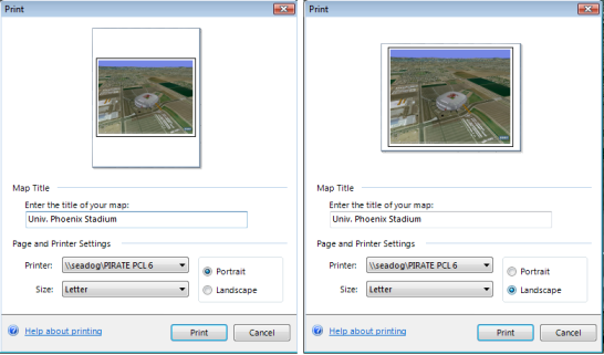
You can print your map directly from ArcGIS Explorer. You can print the currently visible extent, the north arrow, all copyright and attribution information, and a title. ArcGIS Explorer supplies the font for the text and the layout for the printed map; however you can designate the printer to which to direct output, the paper size, and whether to print in landscape or portrait mode. The graphic displayed in the dialog box serves to illustrate the orientation of the map.
 and then click Print.
If you need to add other map surrounds and information to the printed output you may be better served by copying the current view to the Clipboard and pasting it into an application whose documents accept bitmaps and use its printing capabilities.
Note
ArcGIS Explorer disables the Print button if data to be included on the printed map is not completely drawn (that is, streaming is still in progress); as soon as all visible data finishes drawing, you'll be able to print: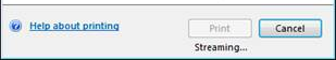
Note that the title you specify is not shown on the preview, but will be printed centered, above the map. Consider using an Image Overlay if the automatic placement and font of the title does not meet your needs.